Roca Entravessada

Last updated
Roca Entravessada

Roca Entravessada 001.jpg

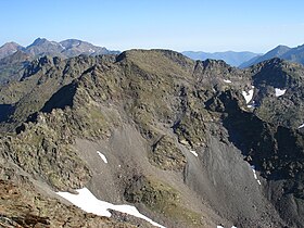
Roca Entravessada from the Coma Pedrosa summit
Highest point
Elevation 2,928 m (9,606 ft)
Coordinates 42°35′54″N01°26′31″E / 42.59833°N 1.44194°E / 42.59833; 1.44194 Coordinates: 42°35′54″N01°26′31″E / 42.59833°N 1.44194°E / 42.59833; 1.44194
Geography
Pyrenees topographic map-en.svg
Red triangle with thick white border.svg
Roca Entravessada
Location in the Pyrenees
Location Pallars Sobirà, Andorra
Catalonia
Parent range Pyrenees
Climbing
First ascent Unknown
Easiest route From Alins or La Massana

Roca Entravessada is a mountain of Catalonia. Located in the Pyrenees, at the border between Spain and Andorra, it has an altitude of 2928 metres above sea level. [1]

Catalonia Autonomous area of northeastern Spain

Catalonia is an autonomous community in Spain on the northeastern corner of the Iberian Peninsula, designated as a nationality by its Statute of Autonomy. Catalonia consists of four provinces: Barcelona, Girona, Lleida, and Tarragona. The capital and largest city is Barcelona, the second-most populated municipality in Spain and the core of the sixth most populous urban area in the European Union. It comprises most of the territory of the former Principality of Catalonia. It is bordered by France (Occitanie) and Andorra to the north, the Mediterranean Sea to the east, and the Spanish autonomous communities of Aragon to the west and Valencia to the south. The official languages are Catalan, Spanish, and the Aranese dialect of Occitan.

Pyrenees Range of mountains in southwest Europe

The Pyrenees is a range of mountains in southwest Europe that forms a natural border between Spain and France. Reaching a height of 3,404 metres (11,168 ft) altitude at the peak of Aneto, the range separates the Iberian Peninsula from the rest of continental Europe, and extends for about 491 km (305 mi) from the Bay of Biscay to the Mediterranean Sea.

Spain Kingdom in Southwest Europe

Spain, officially the Kingdom of Spain, is a country mostly located on the Iberian Peninsula in Europe. Its territory also includes two archipelagoes: the Canary Islands off the coast of Africa, and the Balearic Islands in the Mediterranean Sea. The African enclaves of Ceuta and Melilla make Spain the only European country to have a physical border with an African country (Morocco). Several small islands in the Alboran Sea are also part of Spanish territory. The country's mainland is bordered to the south and east by the Mediterranean Sea except for a small land boundary with Gibraltar; to the north and northeast by France, Andorra, and the Bay of Biscay; and to the west and northwest by Portugal and the Atlantic Ocean.

Contents

The name of the mountain means "Rock Askew" in the Catalan language. One of the routes to reach it passes by the Estanys Forcats from Arinsal, Andorra.

Catalan language Romance language

Catalan is a Western Romance language derived from Vulgar Latin and named after the medieval Principality of Catalonia, in northeastern modern Spain. It is the only official language of Andorra, and a co-official language of the Spanish autonomous communities of Catalonia, the Balearic Islands and Valencia. It also has semi-official status in the Italian commune of Alghero. It is also spoken in the eastern strip of Aragon, in some villages of Region of Murcia called Carche and in the Pyrénées-Orientales department of France. These territories are often called Països Catalans or "Catalan Countries".

Arinsal Place in La Massana, Andorra

Arinsal is a village in Andorra, set at an altitude of between 1550 and 2560 metres, close to the border with Spain at Tor, Pallars. In the summer Arinsal is home to walkers and bikers, as well as those who just want to relax in the mountain scenery. In the winter, it offers skiing and snowboarding for beginners, as well as a good selection of runs for intermediates.
Andorra European microstate between France and Spain

Andorra, officially the Principality of Andorra, also called the Principality of the Valleys of Andorra, is a sovereign landlocked microstate on the Iberian Peninsula, in the eastern Pyrenees, bordering France to the north and Spain to the south. Believed to have been created by Charlemagne, Andorra was ruled by the Count of Urgell until 988, when it was transferred to the Roman Catholic Diocese of Urgell, and the present principality was formed by a charter in 1278. It is known as a principality as it is a diarchy headed by two Princes: the Catholic Bishop of Urgell in Catalonia, Spain, and the President of France.
See also

Related Research Articles

Geography of Andorra

Andorra is a small, landlocked country in southwestern Europe, located in the eastern Pyrenees mountain range and bordered by Spain and France. With an area of 468 km², it is the sixth smallest country in Europe and also the largest of the European microstates.

Cerdanya (comarca) Comarca in Girona and Lleida, Catalonia

Cerdanya is a comarca in northern Catalonia, in the Pyrenees, on the border of Catalonia with France and Andorra. Within Catalonia. Cerdanya is divided between Catalan provinces of Lleida and Girona. Cerdanya's neighbouring comarques are Alt Urgell, Berguedà, and Ripollès.

The Catalans are the citizens of Catalonia, an autonomous community in Spain and the inhabitants of the Roussillon historical region in southeast France, today the Pyrénées Orientales departments, also called Catalonia Nord and Pays Catalan in French.

Volta a Catalunya cycling road race held in Catalonia, Spain

The Volta a Catalunya is a road bicycle race held annually in Catalonia, Spain.

Pica dEstats mountain

Pica d'Estats is a 3,143-metre-high (10,312 ft) mountain in the Montcalm Massif, Pyrenees. on the Spanish–French border, and is the highest mountain in Catalonia.

Alins Municipality in Catalonia, Spain

Alins is a municipality in the comarca of the Pallars Sobirà in Catalonia, Spain. It adjoins France and Andorra. It covers the valleys of the Noguera de Vallferrara and Tor rivers in the north of the comarca. The Pica d'Estats is part of the Montcalm Massif on the frontier between this municipality and Ariège, France. A local road links the municipality with the L-504 road.

Sant Pol de Mar Municipality in Catalonia, Spain

Sant Pol de Mar is a municipality in the comarca of Maresme in Catalonia, Spain. It is located on the coast between Canet de Mar and Calella. The national highway N-II and a station on the RENFE railway line link Sant Pol de Mar to the rest of the coast, while a local road links the town with Arenys de Munt.

Lleida–Alguaire Airport airport in Lleida, Catalonia, Spain

Lleida–Alguaire Airport is an airport located in Alguaire, Catalonia, Spain; about 15 km (9.3 mi) from the centre of Lleida and about 150 km (93 mi) from the centre of Barcelona.

Pyrénées-Orientales Department of France

Pyrénées-Orientales, also known as Northern Catalonia, is a department of Occitanie adjacent to the northern Spanish frontier and the Mediterranean Sea. It also surrounds the tiny Spanish exclave of Llívia, and thus has two distinct borders with Spain.

Puigpedrós mountain

Puigpedrós is a mountain located at the border between Catalonia, Spain and the département of Pyrénées-Orientales (France).

El Petit Encantat is a mountain peak of Catalonia, Spain. Located in the Pyrenees, it is the lower of the two peaks of the Els Encantats mountain, with an altitude of 2,734 metres above sea level.

Costabona

Costabona is a mountain of Catalonia, on the border between Spain and France. Located in the Pyrenees, it has an altitude of 2464 metres above sea level.

Vulturó mountain in Spain

Vulturó is a mountain located in the comarca of Alt Urgell in Catalonia, Spain. It has an elevation of 2,648 metres above sea level. It is the highest mountain in the Serra del Cadí mountain range, and in the Catalan Pre-Pyrenees.

Sant Amand or Puig de Sant Amand is a mountain of Catalonia, Spain. It has an elevation of 1,851 metres above sea level.

Bellmunt (Sant Pere de Torelló) mountain in Spain

Bellmunt is a mountain of Catalonia, Spain. It has an elevation of 1,246 metres above sea level. This mountain dominates the landscape of the Plain of Vic.

Albera Massif mountain range

The Albera Massif is a mountain range located in the south of Pyrénées-Orientales and the north of Catalonia, between France and Spain. It is the main easternmost prolongation of the Pyrenees. Its highest peak is the Puig Neulós, with an elevation of 1,256 metres.

Besiberri Massif mountain in Spain

Besiberri Massif is a mountain massif of the central area of the Pyrenees, Lleida, Catalonia, Spain. It is located at the western limit of the Aigüestortes i Estany de Sant Maurici National Park.

Das, Catalonia Municipality in Catalonia, Spain

Das is a town and municipality in the comarca of Cerdanya, Girona Province, Catalonia, Spain. Its population is 222 according to the 2012 census. It is located amidst the mountains of the Pyrenees.

References

  1. "Mapa Topogràfic de Catalunya". Institut Cartogràfic de Catalunya. Retrieved May 22, 2010..