Roca de la Feixa | |
---|---|
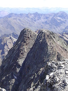
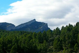
Roca de la Feixa seen from Barruera | |
Highest point | |
Elevation | 2,093 m (6,867 ft) |
Listing | Mountains in Catalonia |
Coordinates | 42°30′12.79″N0°50′19.47″E / 42.5035528°N 0.8387417°E Coordinates: 42°30′12.79″N0°50′19.47″E / 42.5035528°N 0.8387417°E |
Geography | |
Location | Alta Ribagorça, Catalonia |
Parent range | Pyrenees |
Climbing | |
First ascent | Unknown |
Easiest route | Drive to Durro, Vall de Boí, then hike |
Roca de la Feixa is a massive mountain of the Pyrenees, Catalonia, Spain. It has an elevation of 2,093 metres above sea level. [1]
The Pyrenees is a range of mountains in southwest Europe that forms a natural border between Spain and France. Reaching a height of 3,404 metres (11,168 ft) altitude at the peak of Aneto, the range separates the Iberian Peninsula from the rest of continental Europe, and extends for about 491 km (305 mi) from the Bay of Biscay to the Mediterranean Sea.
Catalonia is an autonomous community in Spain on the northeastern corner of the Iberian Peninsula, designated as a nationality by its Statute of Autonomy. Catalonia consists of four provinces: Barcelona, Girona, Lleida, and Tarragona. The capital and largest city is Barcelona, the second-most populated municipality in Spain and the core of the sixth most populous urban area in the European Union. It comprises most of the territory of the former Principality of Catalonia. It is bordered by France (Occitanie) and Andorra to the north, the Mediterranean Sea to the east, and the Spanish autonomous communities of Aragon to the west and Valencia to the south. The official languages are Catalan, Spanish, and the Aranese dialect of Occitan.
Spain, officially the Kingdom of Spain, is a country mostly located on the Iberian Peninsula in Europe. Its territory also includes two archipelagoes: the Canary Islands off the coast of Africa, and the Balearic Islands in the Mediterranean Sea. The African enclaves of Ceuta and Melilla make Spain the only European country to have a physical border with an African country (Morocco). Several small islands in the Alboran Sea are also part of Spanish territory. The country's mainland is bordered to the south and east by the Mediterranean Sea except for a small land boundary with Gibraltar; to the north and northeast by France, Andorra, and the Bay of Biscay; and to the west and northwest by Portugal and the Atlantic Ocean.
This mountain's summit rises above Durro village. It is located within the municipal limits of Vall de Boí, Alta Ribagorça.
The Vall de Boí is a narrow, steep-sided valley and a small municipality in the province of Lleida, in the autonomous community of Catalonia, northern Spain. It lies in the northeastern corner of the comarca of Alta Ribagorça, on the edges of the Pyrenees. It is the largest municipality of the region, with its main town being Barruera.
Alta Ribagorça is one of the comarques of Catalonia, Spain. Its capital is Pont de Suert. The highest peak is the Comaloformo in the massif of Bessiberri. Northeast of the region is the western part of the National Aiguas Tortas and Lake of San Mauricio. It is connected with the Aran valley thorough the Vielha tunnel.
Montserrat is a multi-peaked mountain range near Barcelona, in Catalonia, Spain. It is part of the Catalan Pre-Coastal Range. The main peaks are Sant Jeroni, Montgrós and Miranda de les Agulles.
Fígols is a municipality in the comarca of the Berguedà in Catalonia, Spain. It is situated to the north of Cercs, in the mountains above the Llobregat valley. Deposits of lignite are extracted commercially.
Punta Gabarró or Punta de Gabarró is a mountain of the Montcalm Massif. Located in the Pyrenees, at the border between France and Spain, it has an elevation of 3,105 metres (10,187 ft) above sea level.
Vulturó is a mountain located in the comarca of Alt Urgell in Catalonia, Spain. It has an elevation of 2,648 metres above sea level. It is the highest mountain in the Serra del Cadí mountain range, and in the Catalan Pre-Pyrenees.
Mont Caro or Caro is the highest mountain of the Ports de Tortosa-Beseit, Catalonia, Spain.
Tossal dels Tres Reis or Tossal del Rei is a mountain of the Ports de Tortosa-Beseit massif, Spain. It has an elevation of 1,350 metres above sea level.
Bellmunt is a mountain of Catalonia, Spain. It has an elevation of 1,246 metres above sea level. This mountain dominates the landscape of the Plain of Vic.
La Mussara is a mountain of Catalonia, Spain. It is the highest peak of the Serra de la Mussara, a subrange of the Prades Mountains. Located north of the town of Vilaplana, La Mussara has an elevation of 1055 metres above sea level.
Punta del Curull is a mountain of Catalonia, Spain. It has an elevation of 1,021 metres above sea level. It is the highest point of Serra de la Llena.
Roc de la Guàrdia (Balenyà) is a mountain of Catalonia, Spain. It has an elevation of 891 metres above sea level.
La Moleta or Moleta d'Alfara is a mountain of the Serra de l'Espina, a northern prolongation of the Ports de Tortosa-Beseit, Catalonia, Spain. It has an elevation of 812 metres above sea level. La Moleta rises about 5 km NNW above the village of Alfara de Carles. It is readily identifiable from afar, for its striking squarish shape contrasts sharply with the other summits of the mountain chain.
Muntanya de Santa Bàrbara is a mountain that is part of the northwestern foothills of the Ports de Tortosa-Beseit, Catalonia, Spain. It has an elevation of 751.3 metres above sea level.
Roques de Benet is a compact group of sheer rocky outcrops in the northwestern side of the Ports de Tortosa-Beseit, Catalonia, Spain. The highest summit has an elevation of 1,017.1 metres above sea level.
Penyagalera is a rocky mountain in the northern side of the Ports de Tortosa-Beseit, Aragon, Spain. Punta de Penyagalera, the highest summit, has an altitude of 1,034.4 metres above sea level.
Serra de Paüls is a mountain range in the northern side of the Ports de Tortosa-Beseit, Catalonia, Spain. The highest summit, Punta de l'Aigua has an elevation of 1,091.6 metres above sea level.
Sant Llorenç del Munt is a largely rocky mountain massif in central Catalonia, Spain. The highest summit, where the Monestir de Sant Llorenç del Munt is located, has an elevation of 1,104.2 metres (3,623 ft) above sea level and is known as La Mola. Montcau 1,056.8 metres (3,467 ft) is another important peak of the massif. On the massif, there is a protected area under the name Parc Natural de Sant Llorenç del Munt i l'Obac.
Besiberri Massif is a mountain massif of the central area of the Pyrenees, Lleida, Catalonia, Spain. It is located at the western limit of the Aigüestortes i Estany de Sant Maurici National Park.
Mola de Colldejou is a mountain chain in Catalonia, Spain located north of the Serra de Llaberia in the Catalan Pre-Coastal Range. The highest point is 921.8 m above sea level.
Castell de l'Airosa is a rocky mountain in the eastern side of the Ports de Tortosa-Beseit, Catalonia, Spain. Its summit has an altitude of 953.8 metres above sea level.
![]() | This article about a location in Catalonia is a stub. You can help Wikipedia by expanding it. |