
Clipperton Island, also known as Clipperton Atoll and previously referred to as Clipperton's Rock, is a 8.9 km2 (3.4 sq mi) uninhabited French coral atoll in the eastern Pacific Ocean. It is 10,677 km (6,634 mi) from Paris, France, 5,400 km (2,900 nmi) from Papeete, Tahiti, and 1,080 km (580 nmi) from Mexico. Clipperton Island is the only French possession in the North Pacific.

The Territory of Heard Island and McDonald Islands (HIMI) is an Australian external territory comprising a volcanic group of mostly barren Antarctic islands, about two-thirds of the way from Madagascar to Antarctica. The group's overall size is 372 km2 (144 sq mi) in area and it has 101.9 km (63 mi) of coastline. Discovered in the mid-19th century, the islands lie on the Kerguelen Plateau in the Indian Ocean and have been an Australian territory since 1947. They contain Australia's only two active volcanoes. The summit of one, Mawson Peak, is higher than any mountain in all other Australian states or territories, except Dome Argus, Mount McClintock and Mount Menzies in the Australian Antarctic Territory.

Baja California Sur, officially the Free and Sovereign State of Baja California Sur, is the least populated state and the 31st admitted state of the 32 federal entities which comprise the 31 States of Mexico. It is also the ninth-largest Mexican state in terms of area.

The Revillagigedo Islands or Revillagigedo Archipelago are a group of four volcanic islands in the Pacific Ocean, known for their unique ecosystem. They lie approximately 458 kilometres (285 mi) from Socorro Island south and southwest of Cabo San Lucas, the southern tip of the Baja California Peninsula, and 698 to 1,092 kilometres west of Manzanillo. Historically linked to the Mexican state of Colima, to which they were granted in 1861 to establish a penal colony, the islands are under Mexican federal property and jurisdiction.

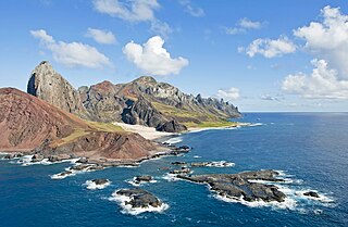
Socorro Island is a small volcanic island in the Revillagigedo Islands, a Mexican possession lying 600 kilometres (370 mi) off the country's western coast. The size is 16.5 by 11.5 km, with an area of 132 km2 (51 sq mi). It is the largest of the four islands of the Revillagigedo Archipelago. The last eruption was in 1993.

Guadalupe Island is a volcanic island located 241 kilometres off the western coast of Mexico's Baja California Peninsula and about 400 km (200 nmi) southwest of the city of Ensenada in the state of Baja California, in the Pacific Ocean. The various volcanoes are extinct or dormant. In 2005 Guadalupe Island and its surrounding waters and islets were declared a biosphere reserve to restore its vegetation and to protect its population of marine mammals and birds. The island is a popular destination for great white shark cage diving. Guadalupe Island is inhabited only by scientists, military personnel operating a weather station, and a small group of seasonal fishermen. The island is mostly arid and has very little surface water.
The Farallon Islands, or Farallones, are a group of islands and sea stacks in the Gulf of the Farallones, off the coast of San Francisco, California, United States. The islands are also sometimes referred to by mariners as the Devil's Teeth Islands, in reference to the many treacherous underwater shoals in their vicinity. The islands lie 30 miles (48 km) outside the Golden Gate and 20 miles (32 km) south of Point Reyes, and are visible from the mainland on clear days. The islands are part of the City and County of San Francisco. The only inhabited portion of the islands is on Southeast Farallon Island (SEFI), where researchers from Point Blue Conservation Science and the U.S. Fish and Wildlife Service stay. The islands are closed to the public.

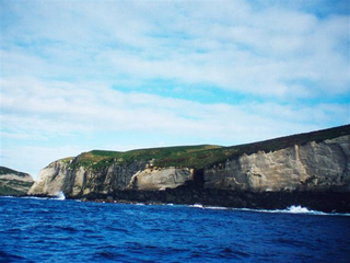
Malpelo is a small oceanic island in the eastern Pacific Ocean, located about 500 km (310 mi) west of the Colombian mainland with a military post manned by the Colombian Armed Forces. It consists of a sheer and barren rock with three high peaks, the highest being Cerro de la Mona with a height of 300 m (980 ft). The island is about 1.5 kilometres in length from northeast to southwest, and 640 metres in width.
Trindade and Martim Vaz is an archipelago located in the South Atlantic Ocean about 1,100 kilometres east of the coast of the Brazilian state of Espírito Santo, of which it forms a part. The archipelago has a total area of 10.4 square kilometres and a navy supported research station of up to 8 persons.The archipelago consists of five islands and several rocks and stacks; Trindade is the largest island, with an area of 10.1 square kilometres ; about 49 kilometres east of it are the tiny Martim Vaz islets, with a total area of 0.3 square kilometres.

Cedros Island is an island in the Pacific Ocean belonging to the state of Baja California, Mexico. The dry and rocky island had a population of 1,350 in 2005 and has an area of 348 square kilometres (134 sq mi) which includes the area of several small nearby islands. Cedros Island is mountainous, reaching a maximum elevation of 1,205 metres (3,953 ft). The economy is based on commercial fishing and salt production. Cedros has a distinctive flora and the traces of some of the earliest human beings in the New World. The ocean around the island is popular with sport fishermen.

Cordell Bank National Marine Sanctuary is a marine sanctuary located off the coast of California. It protects an area of 1,286 sq mi (3,331 km2) of marine wildlife. The administrative center of the sanctuary is on an offshore granite outcrop 4.5 sq mi (12 km2) by 9.5 sq mi (25 km2), located on the continental shelf off of California. The outcrop is, at its closest, 6 mi (10 km) from the sanctuary itself.

Schmieder Bank is a rocky bank west of Point Sur, California, roughly 25 nautical miles (46 km) south of Monterey, supporting an extraordinarily lush biological community, including very large individual colonies of the California hydrocoral, Stylaster californicus.

The Islas San Benito lie in the Pacific Ocean off the west coast of the Mexican state of Baja California, 25 km west of Cedros Island. They are part of the Cedros Island delegación, a subdivision of Ensenada (municipality), Baja California.
Isla Natividad is an island in the Pacific Ocean 6 km west off Punta Eugenia, the northwestern headland of the Mexican state of Baja California Sur. 200 meters off its northwestern end lies Roca María at 27°53′33″N115°13′19″W, with an area of 0.074 km2. Isla Natividad is separated from the mainland at Punta Eugenia by Canal de Dewey, and from Cedros Island, which is 15 km to the north, by Canal de Keller.
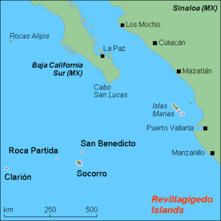
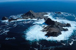
Roca Partida ranks as the smallest of the four Revillagigedo Islands, part of the Free and Sovereign State of Colima in Mexico. The uninhabited island encompasses an extremely small area. Many divers rank it among the most beautiful dive sites in Mexico. Divers must obtain permits from the Mexican Armed Forces to enter the military zone surrounding the island.
Borojevia paracerebrum is a species of calcareous sponge from Mexico. The species is named after its similarity to Borojevia cerebrum.
Grindle Rock is a conspicuous rock, 213 metres (700 ft) high, lying 0.7 nautical miles (1.3 km) west of Bristol Island in the South Sandwich Islands. It was discovered by a British expedition under James Cook in 1775. It was recharted in 1930 by Discovery Investigations personnel on the Discovery II and named by them for Sir Gilbert E.A. Grindle, Permanent Under-Secretary of State for the British Colonies.

Johngarthia lagostoma is a species of terrestrial crab that lives on Ascension Island and three other islands in the South Atlantic. It grows to a carapace width of 110 mm (4.3 in) on Ascension Island, where it is the largest native land animal. It exists in two distinct colour morphs, one yellow and one purple, with few intermediates. The yellow morph dominates on Ascension Island, while the purple morph is more frequent on Rocas Atoll. The species differs from other Johngarthia species by the form of the third maxilliped.

Robert William Schmieder is an American scientist and explorer. Schmieder has had a multidisciplinary career, broadly divided between physics and related physical sciences, and natural science and exploration. In most of his projects, he created and led teams of both professional scientists and volunteers. His work is documented in about 100 technical publications and 10 books. Among his most significant work was the invention of laser spark spectroscopy, the formulation of nanologic, and the concept of underwater islands.
Macauley Island is a volcanic island in New Zealand's Kermadec Islands, approximately halfway between New Zealand's North Island and Tonga in the southwest Pacific Ocean. It is part of a larger submarine volcano that features a 10.5 by 7 kilometres wide underwater caldera northwest of Macauley Island. Two islets, Haszard Island and Newcome Rock, lie east offshore of Macauley Island. The island is mostly surrounded by high cliffs that make accessing it difficult; the inland parts are mostly gently sloping terrain covered with ferns and grasses.


