Related Research Articles

Silver Bow County is a county in the U.S. state of Montana. As of the 2020 census, the population was 35,133. Its county seat is Butte. In 1977, the city and county governments consolidated to form the single entity of Butte-Silver Bow. Additionally, the town of Walkerville is a separate municipality from Butte and is within the county.

Deer Lodge County is a county in the U.S. state of Montana. As of the 2020 census, the population was 9,421. It forms a consolidated city-county government with its county seat of Anaconda. The county was established in 1865. It has had a city-county consolidated government since 1977.

Butte is a consolidated city-county and the county seat of Silver Bow County, Montana, United States. In 1977, the city and county governments consolidated to form the sole entity of Butte-Silver Bow. The city covers 718 square miles (1,860 km2), and, according to the 2020 census, has a population of 34,494, making it Montana's fifth-largest city. It is served by Bert Mooney Airport with airport code BTM.

The Anaconda Copper Mine was a large copper mine in Butte, Montana that closed operations in 1947 and was eventually consumed by the Berkeley Pit, a vast open-pit mine. Originally a silver mine, it was bought for $30,000 in 1881 by an Irish immigrant named Marcus Daly from Michael Hickey, a Civil War veteran, and co-owner Charles X. Larabie. From this beginning Daly, along with partners George Hearst, James Ben Ali Haggin and Lloyd Tevis, created the Anaconda Copper Mining Company, which ultimately became a global mining enterprise that would go on to mine 18 billion pounds of copper over 100 years. At the height of The Anaconda Copper Mining Company, it consisted of the Anaconda and other Butte mines, a smelter at Anaconda, Montana, processing plants in Great Falls, Montana, the American Brass Company, and many other properties spanning multiple countries.
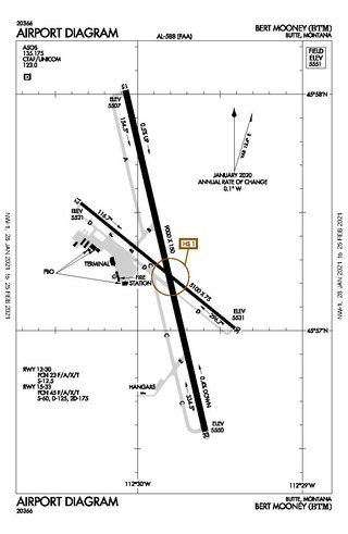
Bert Mooney Airport is a public airport three miles southeast of Butte, in Silver Bow County, Montana, United States. It is owned by the Bert Mooney Airport Authority.
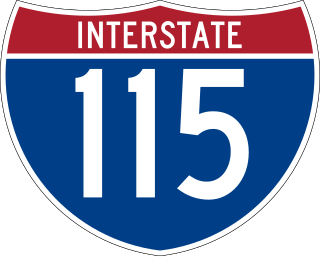
Interstate 115 (I-115) is a 1.194-mile-long (1.922 km) auxiliary Interstate Highway which connects I-15/I-90 to Butte in the U.S. state of Montana. The highway is concurrent with I-15 Bus./I-90 Bus. for its entire length. The highway travels from an incomplete interchange with I-15/I-90 through generally rural areas in western Butte. It also has an interchange with Excelsior Avenue before terminating. The entire route was built to Interstate standards during the 1960s, and was further changed in 2005.
Silver Bow is a neighborhood in Butte, Montana, United States. It lies near the interchange of Interstate 15 and Interstate 90, near Rocker. It is the location of a major rail junction on the Burlington Northern Railroad. Silver Bow is at Exit 119 off I-15, near the Port of Montana. It is well known locally as the location of the Silver Bow Twin Drive-In.

Montana Highway 2 (MT 2) is a 63.241-mile-long (101.777 km) state highway in the southern part of the U.S. state of Montana. It extends from Interstate 15 (I-15) and I-90 in Butte to I-90 in Three Forks. Previously, this roadway was a part of U.S. Route 10 (US 10).

Interstate 90 (I-90) is an east–west transcontinental Interstate Highway across the northern United States, linking Seattle to Boston. The portion in the state of Montana is 552.54 miles (889.23 km) in length, passing through 14 counties in central and southern Montana. It is the longest segment of I-90 within a single state.

The Butte–Anaconda Historic District is a National Historic Landmark (NHL) that spans parts of Walkerville, Butte and Anaconda, Montana, United States. It has the most resources of any U.S. National Historic Landmark District.
Ramsay is a settlement in Silver Bow County, Montana. It is located 10 miles west of Butte. Ramsay lies off exit 216 on Interstate 90. The ZIP Code for Ramsay is 59748.

Melrose is a small community in Silver Bow County, Montana, United States. It is 34 miles (55 km) south of Butte and about 30 miles (48 km) north of Dillon. The zip code is 59743.
Elk Park Pass, elevation 6,352 ft (1,936 m), is a mountain pass on the Continental Divide in southwestern Montana, about 4 miles (6.4 km) northeast of Butte. It is traversed by Interstate 15 and is one of three crossings of the Divide by the Interstate, the others being Monida Pass and Deer Lodge Pass southwest of Butte. Elk Park Pass lies on the border between Silver Bow and Jefferson counties and is remarkable for its highly asymmetrical nature. The approach from the north is through namesake Elk Park, a high, mostly treeless plain, and the grade is almost imperceptible. The elevation at the northeast end of the park, about 10 miles (16 km) from the pass, is about 6,200 ft (1,900 m), only 152 ft (46 m) lower than the pass itself. However, at the south end, the highway drops 750 ft (230 m) from the pass into Butte over a distance of only about 4 miles (6.4 km).
Divide is a rural community in Silver Bow County, Montana, United States. It is administered as part of Butte.

Transportation in Montana comprises many different forms of travel. Montana shares a long border with Canada, hence international crossings are prevalent in the northern section of the state; there are 13 road crossings and one rail crossing.

Silver Bow Creek is a 26-mile-long (42 km) headwater stream of the Clark Fork (river) originating within the city limits of Butte, Montana, from the confluence of Little Basin and Blacktail Creeks. A former northern tributary, Yankee Doodle Creek, no longer flows directly into Silver Bow Creek as it is now captured by the Berkeley Pit. Silver Bow Creek flows northwest and north through a high mountain valley, passing east of Anaconda, Montana, where it becomes the Clark Fork at the confluence with Warm Springs Creek.
Square Butte is a name used for 11 buttes in Montana. Two of the most prominent buttes are located in a) Cascade County, Montana, about 22 miles (35 km) due west of Great Falls and in b) Chouteau County, Montana, about 50 miles (80 km) due east of Great Falls and about 15 miles (24 km) due east of the Highwood Mountains. Charles Marion Russell, the noted Montana western artist used both features as background in his paintings of Montana.
Donald is an unincorporated community in Jefferson County, in the U.S. state of Montana. It is located on Montana Highway 2, 15 miles south of Butte. It is near the Beaver Ponds Trailhead and Toll Mountain in the Beaverhead–Deerlodge National Forest.
Fairmont Hot Springs Resort is a resort in Silver Bow County, Montana, United States.
References
Municipalities and communities of Silver Bow County, Montana, United States | ||
|---|---|---|
| City |  | |
| Town | ||
| Unincorporated communities | ||
| Ghost town | ||
| Neighborhoods | ||
| Footnotes | ‡This populated place also has portions in an adjacent county or counties | |
46°0′12″N112°36′22″W / 46.00333°N 112.60611°W
| International | |
|---|---|
| National | |
| | This Silver Bow County, Montana state location article is a stub. You can help Wikipedia by expanding it. |