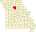
Rockford is an unincorporated community in Chariton County, in the U.S. state of Missouri. [1]
Chariton County is a county located in the North Central portion of the U.S. state of Missouri. As of the 2010 census, the population was 7,831. Its county seat is Keytesville. The county was organized November 16, 1820, from part of Howard County and is named for the Chariton River.
In the United States, a state is a constituent political entity, of which there are currently 50. Bound together in a political union, each state holds governmental jurisdiction over a separate and defined geographic territory and shares its sovereignty with the federal government. Due to this shared sovereignty, Americans are citizens both of the federal republic and of the state in which they reside. State citizenship and residency are flexible, and no government approval is required to move between states, except for persons restricted by certain types of court orders. Four states use the term commonwealth rather than state in their full official names.
Missouri is a state in the Midwestern United States. With over six million residents, it is the 18th-most populous state of the Union. The largest urban areas are St. Louis, Kansas City, Springfield, and Columbia; the capital is Jefferson City. The state is the 21st-most extensive in area. In the South are the Ozarks, a forested highland, providing timber, minerals, and recreation. The Missouri River, after which the state is named, flows through the center of the state into the Mississippi River, which makes up Missouri's eastern border.
A post office called Rockford was established in 1893, and remained in operation until 1925. [2] The community was named for a rocky ford near the original town site. [3]
A ford is a shallow place with good footing where a river or stream may be crossed by wading, or inside a vehicle getting its wheels wet. A ford may occur naturally or be constructed. Fords may be impassable during high water. A low water crossing is a low bridge that allows crossing over a river or stream when water is low but may be covered by deep water when the river is high.
Bynumville is an unincorporated community in eastern Chariton County, Missouri, United States. It is located approximately twelve miles north of Salisbury on Route 129.
Forest Green is an unincorporated community in southeastern Chariton County, Missouri, United States. It is located approximately eight miles south of Salisbury on Route 5.
Prairie Hill is an unincorporated community in eastern Chariton County, Missouri, United States, located approximately eight miles northeast of Salisbury.
Cunningham is an unincorporated community in Chariton County, in the U.S. state of Missouri.
Guthridge is an unincorporated community in Chariton County, in the U.S. state of Missouri.
Hamden is an unincorporated community in Chariton County, in the U.S. state of Missouri.
Lagonda is an unincorporated community in Chariton County, in the U.S. state of Missouri.
Lewis Mill is an unincorporated community in Chariton County, in the U.S. state of Missouri.
Louisville is an unincorporated community in Chariton County, in the U.S. state of Missouri.
Mike is an unincorporated community in Chariton County, in the U.S. state of Missouri.
Musselfork is an unincorporated community in Chariton County, in the U.S. state of Missouri.
Newcomer is an unincorporated community in Chariton County, in the U.S. state of Missouri.
Shannondale is an unincorporated community in Chariton County, in the U.S. state of Missouri.
Westville is an unincorporated community in Chariton County, in the U.S. state of Missouri.
Wien is an unincorporated community in Chariton County, in the U.S. state of Missouri.
Bee Branch Township is a township in Chariton County, in the U.S. state of Missouri.
Chariton Township is a township in Chariton County, in the U.S. state of Missouri.
Cockrell Township is a township in Chariton County, in the U.S. state of Missouri.
Keytesville Township is a township in Chariton County, in the U.S. state of Missouri.
Musselfork Township is a township in Chariton County, in the U.S. state of Missouri.
Coordinates: 39°20′47″N92°54′52″W / 39.34639°N 92.91444°W
A geographic coordinate system is a coordinate system that enables every location on Earth to be specified by a set of numbers, letters or symbols. The coordinates are often chosen such that one of the numbers represents a vertical position and two or three of the numbers represent a horizontal position; alternatively, a geographic position may be expressed in a combined three-dimensional Cartesian vector. A common choice of coordinates is latitude, longitude and elevation. To specify a location on a plane requires a map projection.
This Chariton County, Missouri state location article is a stub. You can help Wikipedia by expanding it. |