Snyder, Missouri | |
|---|---|
  | |
| Coordinates: 39°39′59″N93°14′25″W / 39.66639°N 93.24028°W | |
| Country | United States |
| State | Missouri |
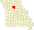
| County | Chariton |
| Elevation | 659 ft (201 m) |
| Time zone | UTC−06:00 (CST) |
| • Summer (DST) | UTC−05:00 (CDT) |
| Area code | 660 |
| GNIS feature ID | 735858 [1] |
Snyder is an unincorporated community in western Chariton County, Missouri, United States. It is located on Missouri Supplemental Route Z, approximately eighteen miles northeast of Carrollton. Snyder's post office has closed, and mail is now delivered from nearby Triplett.