Related Research Articles

Indiana County–Jimmy Stewart Airport is a county-owned public airport two miles (3 km) east of the borough of Indiana, in Indiana County, Pennsylvania. The airport is about 65 miles (105 km) northeast of Pittsburgh and is in the Pittsburgh Combined Statistical Area. It is classified as a business service airport by the Pennsylvania Bureau of Aviation.

Cartersville Airport, Valley of Pumpkinvine Creek Field, is a public use airport located on a small hill by the Etowah River two nautical miles (4km) west of the headwaters of Pumpkinvine Creek and three nautical miles (6 km) southwest of the central business district of Cartersville, in Bartow County, Georgia, United States. It is owned by the Cartersville Bartow Airport Authority.
Pittsburgh–Monroeville Airport is a private airport located one nautical mile (1.8 km) north of the central business district of Monroeville, in Allegheny County, Pennsylvania, United States. The airport is privately owned by the estate of Helen M. Brown and is also known as the Harold W. Brown Memorial Field.
Quakertown Airport is a public airport in Bucks County, Pennsylvania, owned by the Bucks County Airport Authority. It is two miles west of Quakertown, Pennsylvania and was dedicated on 22 January 1965. It is home to the Civil Air Patrol Squadron 904.
Heritage Field is a public use airport in Montgomery County, Pennsylvania, United States. It is located three nautical miles (6 km) east of Pottstown, in Limerick Township. The airport is privately owned by Limerick Aviation LP.

Nampa Municipal Airport is a city-owned public airport in Nampa, in Canyon County, Idaho. The FAA's National Plan of Integrated Airport Systems for 2009–2013 called it a general aviation airport.

Lanett Municipal Airport is a city-owned public-use airport located three nautical miles southwest of the central business district of Lanett, a city in Chambers County, Alabama, United States. According to the FAA's National Plan of Integrated Airport Systems for 2009–2013, it is categorized as a general aviation facility.

Epcot Center Ultralight Flightpark was a private-use ultralight airport located in Osceola County, 13 nautical miles (24 km) northwest of the central business district of Lake Buena Vista, Florida, United States. It was privately owned by the Walt Disney World Company, and was used to launch aircraft used in the "Skyleidoscope" and "Surprise in the Skies" shows at the Epcot theme park.
Miami Homestead General Aviation Airport is a county-owned public-use airport in unincorporated Miami-Dade County, Florida, United States, located 4 miles (6.4 km) northwest of the central business district of Homestead.
Nome City Field is a state-owned public-use airport located one nautical mile north of the central business district of Nome, a city in the Nome Census Area of the U.S. state of Alaska.
Kutztown Airport is a closed, public use airport located one nautical mile (1.85 km) south of the central business district of Kutztown, a borough in Berks County, Pennsylvania, United States.
Skyhaven Airport is a public use airport located in Eaton Township, Wyoming County, Pennsylvania, United States. The airport is one nautical mile south of the central business district of the borough of Tunkhannock.
Lester State Ultralight Flightpark was a state-owned, public-use ultralight airport located two nautical miles east of the central business district of Lester, a town in King County, Washington, United States. It is owned by the WSDOT Aviation Division.
Erie Air Park is a privately-owned public use ultralight airport located one nautical mile north of the central business district of Erie, a village in Whiteside County, Illinois, United States.
The Greene County Airport is a county-owned, public-use airport in Franklin Township, Greene County, Pennsylvania, United States. It is located two nautical miles (4 km) east of the central business district of Waynesburg, Pennsylvania. This airport was included in the National Plan of Integrated Airport Systems for 2009–2013, which categorized it as a general aviation facility.
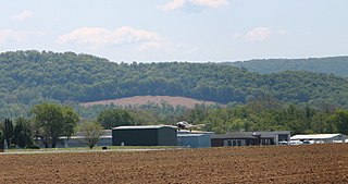
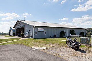
Penn Valley Airport is a public airport a mile north of Selinsgrove, a borough in Snyder County, Pennsylvania. It is owned by the Penn Valley Airport Authority. The National Plan of Integrated Airport Systems for 2011–2015 categorized it as a general aviation facility.
McVille Airport is a privately owned, public use airport located six nautical miles northeast of the central business district of Freeport, a borough in Armstrong County, Pennsylvania, United States.
Mount Pleasant/Scottdale Airport is a privately owned, public use airport in Fayette County, Pennsylvania, United States. It is located three nautical miles (6 km) south of the central business district of Mount Pleasant and near Scottdale, both boroughs in Westmoreland County.
Cherry Ridge Airport is a privately owned, public use airport located three nautical miles (6 km) south of the central business district of Honesdale, a borough in Wayne County, Pennsylvania, United States. This airport was included in the National Plan of Integrated Airport Systems for 2009–2013, which categorized it as a general aviation facility.
Titusville Airport is a city-owned public airport three miles west of Titusville, in Crawford County, Pennsylvania. The National Plan of Integrated Airport Systems for 2011–2015 categorized it as a general aviation facility.
References
- 1 2 3 FAA Airport Form 5010 for 48P PDF . Federal Aviation Administration. Effective 11 February 2010.