Rocky River (Michigan)

Last updated
Rocky River

Rocky River Flowerfield Township Michigan.jpg

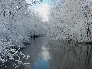
The Rocky River in Flowerfield Township
Country United States
Physical characteristics
Main source Southwest Marcellus Township in Cass County, Michigan
River mouth St. Joseph River in Three Rivers
Length 28 mi (45 km) [1]
Discharge
  • Average rate:
    1.5–2.0 m3/s (53–71 cu ft/s)
Basin features
River system St. Joseph River
Basin size 450 km2 (170 sq mi) [2]

The Rocky River is a 28.3-mile-long (45.5 km) [1] stream located in the southwest part of the U.S. state of Michigan that flows into the St. Joseph River at 41°56′33″N85°37′59″W / 41.94250°N 85.63306°W / 41.94250; -85.63306 [3] in the city of Three Rivers in St. Joseph County. The Rocky River, along with the St. Joseph River and the Portage River, are the three rivers from which the city of Three Rivers takes its name.

Michigan State of the United States of America

Michigan is a state in the Great Lakes and Midwestern regions of the United States. The state's name, Michigan, originates from the Ojibwe word mishigamaa, meaning "large water" or "large lake". With a population of about 10 million, Michigan is the tenth most populous of the 50 United States, with the 11th most extensive total area, and is the largest state by total area east of the Mississippi River. Its capital is Lansing, and its largest city is Detroit. Metro Detroit is among the nation's most populous and largest metropolitan economies.

St. Joseph River (Lake Michigan) tributary of Lake Michigan in Michigan and Indiana

The St. Joseph River is a 206 miles (332 km) long tributary of Lake Michigan flowing generally westerly through southern Michigan and northern Indiana, United States, to its terminus on the southeast shore of the lake. It drains a primarily rural farming area in the watershed of Lake Michigan. It was enormously important to Native Americans and greatly aided in the colonial exploration, settlement and administration of New France and the nascent United States as a canoe route between Lake Michigan and the watershed of the Mississippi River.

Three Rivers, Michigan City in Michigan, United States

Three Rivers is a city in St. Joseph County in southwestern Michigan in the United States. The population was 7,811 at the 2010 census.

The Rocky River rises in southwest Marcellus Township in Cass County at 41°59′43″N85°51′04″W / 41.99528°N 85.85111°W / 41.99528; -85.85111 . [3] It flows to the northeast, arcing gently to the southeast before turning sharply to the south in eastern Flowerfield Township, shortly after being joined by the Flowerfield Creek. It then flows mostly southward until joining the St. Joseph River in Three Rivers.

Marcellus Township, Michigan Township in Michigan, United States

Marcellus Township is a civil township of Cass County in the U.S. state of Michigan. The population was 2,539 at the 2010 census. The village of Marcellus is within the township.

Cass County, Michigan county in Michigan, United States of America

Cass County is a county in the U.S. state of Michigan. As of the 2010 census, the population was 52,293. Its county seat is Cassopolis.

Flowerfield Township, Michigan Township in Michigan, United States

Flowerfield Township is a civil township of St. Joseph County in the U.S. state of Michigan. The population was 1,592 at the 2000 census.

The Rocky River watershed encompasses over 112,000 acres (45,000 ha) and drains all or portions of the following cities and townships: [2]

Newberg Township, Michigan Township in Michigan, United States

Newberg Township is a civil township of Cass County in the U.S. state of Michigan. The population was 1,632 at the 2010 census.

Penn Township, Michigan Township in Michigan, United States

Penn Township is a civil township of Cass County in the U.S. state of Michigan. The population was 1,774 at the 2010 census.

Volinia Township, Michigan Township in Michigan, United States

Volinia Township is a civil township of Cass County in the U.S. state of Michigan. The population was 1,112 at the 2010 census. When the township was organized in 1833, it was at first named Volhynia, after the province in Poland. It is believed to have been given to honor General Tadeusz Kościuszko, the Polish patriot who helped the United States during the American Revolutionary War. The name was altered first to "Volenia" and then by 1901 or earlier to "Volinia".

Tributaries

Related Research Articles

Paw Paw River river in Michigan

The Paw Paw River is located in the U.S. state of Michigan in the southwest portion of the lower peninsula. It is formed by the confluence of the north and south branches at 42°15′17″N85°55′36″W in Waverly Township in the northeast of Van Buren County. It flows approximately 61.8 miles (99.5 km) through Van Buren County and Berrien County until joining the St. Joseph River just above its mouth on Lake Michigan at Benton Harbor.

St. Joseph River (Maumee River tributary) tributary of the Maumee River in Ohio and Indiana

The St. Joseph River is an 86.1-mile-long (138.6 km) tributary of the Maumee River in northwestern Ohio and northeastern Indiana in the United States, with headwater tributaries rising in southern Michigan. It drains a primarily rural farming region in the watershed of Lake Erie.

Fawn River (Michigan) river in the United States of America

The Fawn River is a 55.4-mile-long (89.2 km) river in southwest Michigan and northeast Indiana in the United States. It flows into the St. Joseph River in the city of Constantine, Michigan. The headwaters rise in a series of lakes and marshes in northern Steuben County, Indiana near Pokagon State Park, where it is known as "Crooked Creek" and "Little Fawn River". It flows west-northwest across the northeast corner of LaGrange County, Indiana and then over the state line across the southeast corner of Branch County, Michigan before entering St. Joseph County, Michigan. Passing to the south of Sturgis, Michigan, the river meanders across the state line a few more times before flowing north into Constantine. Except for Constantine, the river does not flow through any large communities, although it passes near Fremont, Indiana, Orland, Indiana, Sturgis, Howe, Indiana, and White Pigeon, Michigan.

Cedar Creek (Indiana) tributary of the St. Joseph River in Indiana, USA

Called Mes-kwah-wa-se-pe or "old redwood creek" by Native Americans, Cedar Creek is the largest tributary of the St. Joseph River, draining 174,780 acres (707.3 km2) in northeastern Indiana. It is 31.9 miles (51.3 km) long, rising in northwestern DeKalb County and joining the St. Joseph just below the Cedarville Dam in Allen County.

Chippewa River (Michigan) river in Michigan

The Chippewa River is a stream in the U.S. state of Michigan that runs 91.8 miles (147.7 km) through the central Lower Peninsula. The Chippewa is a tributary of the Tittabawassee River and is thus part of the Saginaw River drainage basin. The river is named after the Chippewa people.

Carp River is a 40.2-mile-long (64.7 km) river in Chippewa and Mackinac counties in the U.S. state of Michigan. 21.7 miles (34.9 km) of the river were added to the National Wild and Scenic Rivers System in 1992.

Black River (Southwest Michigan) river in southwest Michigan

Black River is a 4.2-mile-long (6.8 km) river in the southwest part of the U.S. state of Michigan that empties into Lake Michigan in South Haven at 42°24′08″N86°17′04″W, where it discharges past the South Pier Lighthouse. The river takes its name from the dark brown color of its water, which is caused by suspended sediments and organic materials picked up along its course. The river supports a variety of wildlife including trout, snapping turtles, leeches, and many other varieties of flora and fauna. The Black River watershed encompasses 287 square miles (740 km2) across two counties and 13 townships.

Black River (St. Clair County) tributary of the St. Clair River in Michigan, United States

Black River is an 81.0-mile-long (130.4 km) river in the U.S. state of Michigan, flowing into the St. Clair River in the city of Port Huron. The Black River Canal in northern Port Huron extends east into Lake Huron near Krafft Road.

Dowagiac River river in the United States of America

The Dowagiac River is a southwesterly flowing 30.9-mile-long (49.7 km) stream in the Lower Peninsula of the U.S. state of Michigan. It is tributary to the St. Joseph River which flows, in turn, into eastern Lake Michigan.

Cedar River is an 11.6-mile-long (18.7 km) stream in Antrim County in the U.S. state of Michigan and is part of the Elk River Chain of Lakes Watershed, a tributary of Lake Michigan.

Devils Lake is the name of a few lakes in the U.S. state of Michigan.

Coldwater River is a 29.5-mile-long (47.5 km) stream in the U.S. state of Michigan. Located in Branch County, the river rises in Ovid Township at 41°50′14″N84°59′13″W as the outflow of Coldwater Lake. Flowing north and west, it is joined by the outflow from the Lake of the Woods and continues north for several miles. West of the city of Coldwater, it flows through a series of lakes: South Lake, Messenger Lake, Cemetery Lake, North Lake, Randall Lake, Morrison Lake, Craig Lake, and Hodunk Pond. It then continues to the northwest and empties into the St. Joseph River in the village of Union City at 42°03′58″N85°07′48″W.

Betsie River

The Betsie River is a 54.0-mile-long (86.9 km) stream in the northwest part of the U.S. state of Michigan. The name is derived from the French la rivière aux Bec-scies, meaning river of sawbill ducks (bec-scie). Other alternate names include Aug-sig-o-sebe, Aux Buscies, Betsey's River, Black Robe, Gay-she-say-ing, Riviere du Pere Marquette, Sawbill Ducks, and Shelldrake Ducks. The river is mostly within Benzie County, although the river rises in southwest Grand Traverse County and flows briefly through northern Manistee County, Michigan.

Boyne River is a stream in Northern Michigan, named for the River Boyne in Leinster, Ireland. Together with the north and south branches, the river system has approximately 22 miles (35 km) of mainstream and the water basin drains 40,320 acres (163.2 km2). Boyne River is Lake Charlevoix's second-largest tributary, after the Jordan River.

Prairie River (Michigan) river in the United States of America

The Prairie River is a small river that flows 54 miles (87 km) through Branch and St. Joseph counties in Michigan. The river rises at 41°48′20″N85°00′54″W in northern Kinderhook Township in Branch County, and flows west-northwest into the St. Joseph River at 41°54′45″N85°38′21″W just south of the city of Three Rivers, Michigan.

Ocqueoc River river in the United States of America

The Ocqueoc River is stream in Presque Isle County in the northeastern part of the lower peninsula in the U.S. state of Michigan. It is 34.2 miles (55.0 km) long and encompasses a watershed of approximately 94,394 acres (382.00 km2).

Klingers is an unincorporated community in St. Joseph County in the southwest region of the U.S. state of Michigan.

Nottawa Creek is a 33.9-mile-long (54.6 km) stream in the U.S. state of Michigan that flows into the St. Joseph River at 42°00′15″N85°23′40″W, approximately three miles east of the village of Mendon.

Portage River (Jackson County, Michigan)

The Portage River is a 15.5-mile-long (24.9 km) river in the U.S. state of Michigan, flowing mostly southwesterly through northeast Jackson County.

Pine River (Chippewa River) tributary of the Chippewa River in the Lower Peninsula of the U.S. state of Michigan

The Pine River is a 103-mile-long (166 km) river in the Lower Peninsula of the U.S. state of Michigan. The Pine River is a tributary of the Chippewa River and is thus part of the Saginaw River drainage basin.

References

  1. 1 2 U.S. Geological Survey. National Hydrography Dataset high-resolution flowline data. The National Map, accessed May 19, 2011
  2. 1 2 Rocky River Watershed Management Plan, prepared by Sarah VanDelfzijl, Watershed Coordinator, St. Joseph County Conservation District
  3. 1 2 U.S. Geological Survey Geographic Names Information System: Rocky River
  4. U.S. Geological Survey Geographic Names Information System: Kerr Creek
  5. U.S. Geological Survey Geographic Names Information System: Little Pleasant Lake
  6. U.S. Geological Survey Geographic Names Information System: Pleasant Lake
  7. U.S. Geological Survey Geographic Names Information System: Armalege Drain
  8. U.S. Geological Survey Geographic Names Information System: Goose Lake
  9. U.S. Geological Survey Geographic Names Information System: Flowerfield Creek
  10. U.S. Geological Survey Geographic Names Information System: Spring Creek
  11. U.S. Geological Survey Geographic Names Information System: Four County Drain
  12. U.S. Geological Survey Geographic Names Information System: Ayers Lake
  13. U.S. Geological Survey Geographic Names Information System: Sheldon Creek
  14. U.S. Geological Survey Geographic Names Information System: Lewis Lake
  15. U.S. Geological Survey Geographic Names Information System: Mud Lake
  16. U.S. Geological Survey Geographic Names Information System: Pickerel Lake
  17. U.S. Geological Survey Geographic Names Information System: Skyhawk Lake
  18. U.S. Geological Survey Geographic Names Information System: Streaters Mill Pond
  19. U.S. Geological Survey Geographic Names Information System: Bogart Lake
  20. U.S. Geological Survey Geographic Names Information System: Huyck Lake