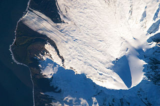
The Territory of Heard Island and McDonald Islands is an Australian external territory comprising a volcanic group of barren Antarctic islands, about two-thirds of the way from Madagascar to Antarctica. The group's overall size is 372 square kilometres (144 sq mi) in area and it has 101.9 km (63 mi) of coastline. Discovered in the mid-19th century, the islands have been an Australian territory since 1947 and contain the country's only two active volcanoes. The summit of one, Mawson Peak, is higher than any mountain on the Australian mainland. The islands lie on the Kerguelen Plateau in the Indian Ocean.
Saddle Point is a rocky point separating Corinthian Bay and Mechanics Bay on the north coast of Heard Island in the Antarctic.

Jacka Glacier is a 0.8-mile (1.3 km) long glacier which flows northeast from Hayter Peak and terminates in icefalls opposite Vanhoffen Bluff on the north side of Heard Island in the southern Indian Ocean. The glacier appears to be roughly charted on an 1860 sketch map compiled by Captain H.C. Chester, an American sealer operating in the area during this period. It was surveyed in 1948 by the Australian National Antarctic Research Expeditions, and named by them for Fred J. Jacka, an expedition physicist.
Atlas Cove is a cove on the north coast of Heard Island in the southern Indian Ocean, and is entered between the base of the Laurens Peninsula and Rogers Head.

Abbotsmith Glacier is a well-defined glacier, 3 miles (5 km) long, descending from the ice-covered west slopes of Big Ben to the west side of Heard Island in the southern Indian Ocean. The glacier lies between Walsh and Henderson Bluffs. Surveyed in 1948 by the ANARE who named it for John Abbotsmith, engineer with the party.

Baudissin Glacier is a tidewater glacier on the north side of Heard Island. in the southern Indian Ocean. Located 1 nautical mile (1.9 km) west of Challenger Glacier, Baudissin Glacier is 1.5 nautical miles (2.8 km) wide and flows into the western part of Corinthian Bay. The terminus of Baudissin Glacier is located at the western side of Corinthian Bay, at Sealers Cove. To the east of Baudissin Glacier is Challenger Glacier, whose terminus is located at the eastern side of Corinthian Bay, close west to Saddle Point. To the south of Baudissin Glacier is Schmidt Glacier, and to the northwest is Atlas Cove. Kildalkey Head is west of Schmidt Glacier. To the south of Schmidt Glacier is Vahsel Glacier, whose terminus is at South West Bay, between Erratic Point and Cape Gazert. Immediately south of Vahsel Glacier is Allison Glacier. Click here to see a map of Baudissin Glacier and the northwestern coast of Heard Island.
Laurens Peninsula is a rugged peninsula surmounted by several ice-covered peaks that forms the northwestern part of Heard Island in the southern Indian Ocean. The name was applied by the Australian National Antarctic Research Expedition following their survey in 1948. It derives from the existing name Cape Laurens, applied for the northwestern extremity of this peninsula after the American bark Laurens which, under Captain Franklin F. Smith, visited Heard Island in 1855–56 and assisted in initiating sealing operations there.

Downes Glacier is a broad tidewater glacier on the north side of Heard Island in the southern Indian Ocean. It flows north on both sides of Cape Bidlingmaier to the north coast of Heard Island. To the east of Downes Glacier is Ealey Glacier, whose terminus is located close southeast of Cape Bidlingmaier. To the west of Downes Glacier is Challenger Glacier, whose terminus is located at the eastern side of Corinthian Bay, close west to Saddle Point. Saddle Point separates Downes Glacier from Challenger Glacier.

Schmidt Glacier is a glacier, 0.7 nautical miles (1.3 km) long, flowing west from Baudissin Glacier between Mount Drygalski and North West Cornice, on the west side of Heard Island in the southern Indian Ocean. To the north of Schmidt Glacier is Baudissin Glacier, whose terminus is located at the western side of Corinthian Bay, near Sealers Cove. Kildalkey Head is west of Schmidt Glacier. To the south of Schmidt Glacier is Vahsel Glacier, whose terminus is at South West Bay, between Erratic Point and Cape Gazert. Immediately south of Vahsel Glacier is Allison Glacier. Click here to see a map of Schmidt Glacier and the northwestern coast of Heard Island.

Allison Glacier is an ice stream on the west side of Heard Island in the southern Indian Ocean. Allison Glacier flows from Big Ben massif down to the sea to the south of Cape Gazert.
To the north of Allison Glacier is Vahsel Glacier, whose terminus is at South West Bay, between Erratic Point and Cape Gazert. Immediately to the north of Vahsel Glacier is Schmidt Glacier, whose terminus is located between Mount Drygalski and North West Cornice. To the south of Allison Glacier is Abbotsmith Glacier, while Cape Gazert is immediately west.
South West Bay is an open bay indenting the west side of Heard Island immediately north of Cape Gazert in the southern Indian Ocean. The bay was roughly charted on an 1860 sketch map compiled by Captain H.C. Chester, an American sealer. The name "S.W. Bay" appears on an 1882 chart compiled by Ens. Washington Irving Chambers aboard the USS Marion at Heard Island in January 1882. The bay name appears to have developed from an American sealer name, "Southwest Beach," in use about 1860 for the pebble beach at the north end of this bay.
Mount Drygalski is an ice-free hill, 210 metres (700 ft) high, standing 0.7 nautical miles southeast of Atlas Cove, near the northwest end of Heard Island in the southern Indian Ocean. The feature appears to have been roughly charted on an 1882 sketch map compiled by Ensign Washington Irving Chambers aboard the USS Marion during the rescue of the shipwrecked crew of the American sealing bark Trinity. It was more accurately charted and named by the First German Antarctica Expedition in 1902. Professor Erich von Drygalski, the leader of the German Expedition, was a member of the landing party which investigated the area between Rogers Head and the summit of this feature.
Corinthian Bay is a bay, which is 3 miles (5 km) wide and recedes 1.5 miles (2.4 km), entered between Rogers Head and Saddle Point on the north coast of Heard Island in the southern Indian Ocean. The name appears on an early chart compiled by American sealers. It was probably given by Captain Erasmus Darwin Rogers, American whaler and sealer, after his vessel Corinthian in which he made the first landing on Heard Island in March 1855. Nearby features include Corinth Head.
Cape Bidlingmaier is a rocky cape at the east side of the entrance to Mechanics Bay, on the north side of Heard Island in the southern Indian Ocean. The feature appears to have been known to American sealers as Morgan's Point, as shown by Captain H.C. Chester's 1860 sketch map of the island. The name Negros Head was also in use by American sealers during the 1860–70 period. The name Bidlingmaier was applied by the First German Antarctica Expedition, under Erich von Drygalski, who made a running survey and landing along the north side of the island in 1902. Friedrich Bidlingmaier served as magnetician and meteorologist with the expedition.
Mechanics Bay is a bay, 1 nautical mile (2 km) wide, lying immediately east of Saddle Point on the north coast of Heard Island in the southern Indian Ocean. It was named by American sealers after the schooner Mechanic, a tender to the Corinthian in Captain Erasmus Darwin Rogers' sealing fleet which landed at Heard Island in 1855.
Cave Bay is a cove, 0.3 nautical miles (0.6 km) wide, which has been formed by the erosion of an extinct volcanic crater of which Mount Andree forms the north side, indenting the west side of Heard Island between West Bay and South West Bay. The cove is roughly charted on an American sealer's sketch map prepared during the 1860–70 period. It was more accurately charted and first named on a geological sketch map illustrating the 1929 work of the British Australian New Zealand Antarctic Research Expedition under Douglas Mawson.
Mount Olsen is a snow-covered peak standing 0.2 nautical miles (0.4 km) east of Hayter Peak on Laurens Peninsula, in the northwest part of Heard Island.
Corinth Head is a rocky headland 0.5 nautical miles (1 km) southeast of Rogers Head, overlooking the west side of Corinthian Bay, on the north side of Heard Island. The feature appears to have been roughly charted by the First German Antarctica Expedition under Erich von Drygalski, who made a running survey of the north side of the island in 1902. It was resurveyed by the Australian National Antarctic Research Expeditions in 1948, and so named by them because of its close association with Corinthian Bay.

The McDonald Islands are the peaks of a volcano in the southern Indian Ocean in the vicinity of Heard Island. The islands are Australian external territory. Prior to 1992, the volcano had not erupted in the previous 75,000 years.
Church Rock is a dark, steeple-like rock, 16 m high, lying at the head of Corinthian Bay opposite the terminus of Baudissin Glacier, off the north side of Heard Island.


![]()


