
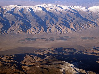
Long Valley Caldera is a depression in eastern California that is adjacent to Mammoth Mountain. The valley is one of the Earth's largest calderas, measuring about 20 mi (32 km) long (east-west), 11 mi (18 km) wide (north-south), and up to 3,000 ft (910 m) deep.
A hot spring, hydrothermal spring, or geothermal spring is a spring produced by the emergence of geothermally heated groundwater onto the surface of the Earth. The groundwater is heated either by shallow bodies of magma or by circulation through faults to hot rock deep in the Earth's crust. In either case, the ultimate source of the heat is radioactive decay of naturally occurring radioactive elements in the Earth's mantle, the layer beneath the crust.

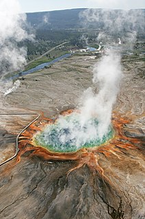
The geothermal areas of Yellowstone include several geyser basins in Yellowstone National Park as well as other geothermal features such as hot springs, mud pots, and fumaroles. The number of thermal features in Yellowstone is estimated at 10,000. A study that was completed in 2011 found that a total of 1,283 geysers have erupted in Yellowstone, 465 of which are active during an average year. These are distributed among nine geyser basins, with a few geysers found in smaller thermal areas throughout the Park. The number of geysers in each geyser basin are as follows: Upper Geyser Basin (410), Midway Geyser Basin (59), Lower Geyser Basin (283), Norris Geyser Basin (193), West Thumb Geyser Basin (84), Gibbon Geyser Basin (24), Lone Star Geyser Basin (21), Shoshone Geyser Basin (107), Heart Lake Geyser Basin (69), other areas (33). Although famous large geysers like Old Faithful are part of the total, most of Yellowstone's geysers are small, erupting to only a foot or two. The hydrothermal system that supplies the geysers with hot water sits within an ancient active caldera. Many of the thermal features in Yellowstone build up sinter, geyserite, or travertine deposits around and within them.

{{short description}dam in Arizona}}

The geothermal areas in Lassen Volcanic National Park include several groups of hot springs and fumaroles, as remnants of former volcanic activity, exist in Lassen Volcanic National Park in northeastern California. Most of these lie in or are closely adjacent to Mount Tehama's caldera. Bumpass Hell is the most spectacular of these, but others of importance are Sulphur Works, Little Hot Springs Valley, Boiling Springs Lake and Devil's Kitchen. In each thermal area, the highest temperature of water generally is close to the boiling temperature at the altitude of the particular spring or fumarole — 198 °F (92 °C) at Bumpass Hell and 191 °F (88 °C) on the northwest flanks of Lassen Peak. Temperatures as high as 230 °F (110 °C) have been recorded in the park.

Lake Mead National Recreation Area is a U.S. national recreation area in southeastern Nevada and northwestern Arizona. Operated by the National Park Service, Lake Mead NRA follows the Colorado River corridor from the westernmost boundary of Grand Canyon National Park to just north of the cities of Laughlin, Nevada and Bullhead City, Arizona. It includes all of the eponymous Lake Mead as well as the smaller Lake Mohave – reservoirs on the river created by Hoover Dam and Davis Dam, respectively – and the surrounding desert terrain and wilderness.

The Folsom Lake State Recreation Area surrounds Folsom Lake in the foothills of the Sierra Nevada, and is managed by the California Department of Parks and Recreation. It is located near the city of Folsom, California, about 25 miles (40 km) east of Sacramento.

Lake Oroville is a reservoir formed by the Oroville Dam impounding the Feather River, located in Butte County, northern California. The lake is situated 5 miles (8.0 km) northeast of the city of Oroville, within the Lake Oroville State Recreation Area, in the western foothills of the Sierra Nevada. Known as the second-largest reservoir in California, Lake Oroville is treated as a keystone facility within the California State Water Project by storing water, providing flood control, recreation, freshwater releases assist in controlling the salinity intrusion into the Sacramento-San Joaquin Delta and protecting fish and wildlife.

The Muddy River, formerly known as the Moapa River, is a short river located in Clark County, in southern Nevada, United States. It is in the Mojave Desert, approximately 60 miles (97 km) north of Las Vegas.

Thermal pollution, sometimes called "thermal enrichment," is the degradation of water quality by any process that changes ambient water temperature. Thermal pollution is the rise or fall in the temperature of a natural body of water caused by human influence. Thermal pollution, unlike chemical pollution, results in a change in the physical properties of water. A common cause of thermal pollution is the use of water as a coolant by power plants and industrial manufacturers. Urban runoff—stormwater discharged to surface waters from rooftops, roads and parking lots—and reservoirs can also be a source of thermal pollution. Thermal pollution can also be caused by the release of very cold water from the base of reservoirs into warmer rivers.
Lake Anna is one of the largest freshwater inland reservoirs in Virginia, covering an area of 13,000 acres (53 km2), and located 72 miles (116 km) south of Washington, D.C. in Louisa and Spotsylvania counties. The lake is easily accessible from Fredericksburg, Richmond, Charlottesville, Northern Virginia, and Washington, D.C. and is one of the most popular recreational lakes in the state.

Las Vegas Bay is a bay at the western edge of Lake Mead in the U.S. state of Nevada. The bay is located within the Lake Mead National Recreation Area to the northeast of the city of Henderson, Nevada, near the junction of Lake Mead Drive and Lake Mead Boulevard. A public campground and boat access are available in Las Vegas Bay. Low water levels of Lake Mead have rendered the marina there inoperable, and it has moved to the Hemenway Boat Harbor, in the south end of the Boulder Basin. The launch ramp there has also been closed due to the water levels.

Lake Mohave is a reservoir on the Colorado River between the Hoover Dam and Davis Dam in Cottonwood Valley defining the border between Nevada and Arizona in the United States. This 67 mile stretch of the Colorado River flows past Boulder City, Nelson, Searchlight, Cottonwood Cove, Cal-Nev-Ari, and Laughlin to the west in Nevada and Willow Beach and Bullhead City to the east in Arizona. A maximum width of 4 miles wide and an elevation of 647 feet (197 m), Lake Mohave encompasses 28,260 acres of water. As Lake Mead lies to the north of the Hoover Dam, Lake Mohave and adjacent lands forming its shoreline are part of the Lake Mead National Recreation Area administered by the U.S. National Park Service.
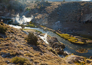
Hot Creek, starting as Mammoth Creek, is a stream in Mono County of eastern California, in the Western United States. It is within the Inyo National Forest.

Scovern Hot Springs is a thermal spring system, and former settlement in the Kern River Valley of the Southern Sierra Nevada, in Kern County, California.

Gold Strike Hot Springs, also known as Goldstrike Hot Springs, Nevada Hot Springs and Gold Strike Canyon Hot Springs are a group of hot mineral water springs near Hoover Dam on the Arizona/Nevada border near historic Boulder City.
Fish Lake Hot Well, also known as Fish Lake Hot Spring and Fish Lake Valley Hot Well is a geothermal hot spring in Nevada.

Soldier Meadows hot spring system is a group of hot and warm springs near the town of Gerlach, Nevada.
