Roman road from Trier to Cologne

Last updated
Section of the Tabula Peutingeriana (4th century) showing the Roman road from Trier to Cologne Tabula Peutingeriana 800x350.jpg
Section of the Tabula Peutingeriana (4th century) showing the Roman road from Trier to Cologne

The Roman road from Trier to Cologne is part of the Via Agrippa , a Roman era long distance road network, that began at Lyon. The section from Augusta Treverorum (Trier) to the CCAA (Cologne), the capital of the Roman province of Germania Inferior, had a length of 66 Roman leagues (= 147 km). [1] It is described in the Itinerarium Antonini , the itinerarium by Emperor Caracalla (198–217), which was revised in the 3rd century, and portrayed in the Tabula Peutingeriana or Peutinger Table, the Roman map of the world discovered in the 16th century, which shows the Roman road network of the 4th century. [2]

<i>Via Agrippa</i> Roman roads in Gaul

Via Agrippa, is any stretch of the network of Roman roads in Gaul that was built by Marcus Vipsanius Agrippa, to whom Octavian entrusted the reorganization of the Gauls. In all, the Romans built 21,000 kilometres (13,000 mi) of roads in Gaul.

Lyon Prefecture and commune in Auvergne-Rhône-Alpes, France

Lyon is the third-largest city and second-largest urban area of France. It is located in the country's east-central part at the confluence of the rivers Rhône and Saône, about 470 km (292 mi) south from Paris, 320 km (199 mi) north from Marseille and 56 km (35 mi) northeast from Saint-Étienne. Inhabitants of the city are called Lyonnais.

Trier Place in Rhineland-Palatinate, Germany

Trier, formerly known in English as Treves and Triers, is a city in Germany on the banks of the Moselle. Trier lies in a valley between low vine-covered hills of red sandstone in the west of the state of Rhineland-Palatinate, near the border with Luxembourg and within the important Moselle wine region. The German philosopher and one of the founders of Marxism, Karl Marx was born in the city in 1818.

Contents

Route

Roman milestone from the 3rd century - found during railway construction of the line from Cologne to Trier around 1860 SteinruetschMeilenstein.jpg
Roman milestone from the 3rd century – found during railway construction of the line from Cologne to Trier around 1860

The route of the Roman road is described in the Itinerarium Antonini as passing through seven stations, whose distance is given in leagues.
1 Gallic league corresponds to 1.5 milia passum = ca. 2,200 metres, where 1 milia passum = 1,000 passus = ca. 1,480 metres [3]

A league is a unit of length. It was common in Europe and Latin America, but is no longer an official unit in any nation. The word originally meant the distance a person could walk in an hour. Since the Middle Ages, many values have been specified in several countries.

The later Peutinger Table describes the same places with the exception of Tolbiacum (Zülpich) and Belgica (Billig), but without the addition of the word vicus. However, the entries about the route vary considerably from those of the Antonine itinerary and are often interpreted as transcription errors. [4]

Roman station nameCurrent name Distance
Interval From Trier
Leagues Kilometres Kilometres
Treveros Trier
Beda vicus Bitburg XII 27 27
Ausava vicus Büdesheim XII 27 54
Egorigio vicus Jünkerath VII 16 70
Marcomago vicus Marmagen VIII 18 88
Tolbiaco vicus Zülpich XII 24 112
Agrippina Köln XVI 35 147

[5]

Recent research and archaeological surveys of a corridor up to 250 metres wide along the road have shown that at intervals of no more than every three or four kilometres, and in densely populated areas often as little as a few hundred metres, there were sites of various vici (settlements), mansiones (inns) and mutationes , (coaching inns), stationes beneficiarium (military road posts) and religious votive stones, immediately by the road. This is especially true of crossroads, road junctions and river crossings. This road infrastructure was encouraged by the cursus publicus , a sort of national postal system. [6]

Survey (archaeology) Non-destructive exploration of the archaeological material culture in a given area

In archaeology, survey or field survey is a type of field research by which archaeologists search for archaeological sites and collect information about the location, distribution and organization of past human cultures across a large area. Archaeologists conduct surveys to search for particular archaeological sites or kinds of sites, to detect patterns in the distribution of material culture over regions, to make generalizations or test hypotheses about past cultures, and to assess the risks that development projects will have adverse impacts on archaeological heritage. The surveys may be: (a) intrusive or non-intrusive, depending on the needs of the survey team and; (b) extensive or intensive, depending on the types of research questions being asked of the landscape in question. Surveys can be a practical way to decide whether or not to carry out an excavation, but may also be ends in themselves, as they produce important information about past human activities in a regional context.

Vicus kind of populated place in the Roman Empire

In Ancient Rome, the vicus was a neighborhood or settlement. During the Republican era, the four regiones of the city of Rome were subdivided into vici. In the 1st century BC, Augustus reorganized the city for administrative purposes into 14 regions, comprising 265 vici. Each vicus had its own board of officials who oversaw local matters. These administrative divisions are recorded as still in effect at least through the mid-4th century.

Mansion large dwelling house

A mansion is a large dwelling house. The word itself derives through Old French from the Latin word mansio "dwelling", an abstract noun derived from the verb manere "to dwell". The English word manse originally defined a property large enough for the parish priest to maintain himself, but a mansion is no longer self-sustaining in this way. Manor comes from the same root—territorial holdings granted to a lord who would "remain" there—hence it is easy to see how the word mansion got its meaning.

Related Research Articles

Great St. Martin Church, Cologne Church in Cologne, Germany

The Great Saint Martin Church is a Romanesque Catholic church in Cologne, Germany. Its foundations rest on remnants of a Roman chapel, built on what was then an island in the Rhine. The church was later transformed into a Benedictine monastery. The current buildings, including a soaring crossing tower that is a landmark of Cologne's Old Town, were erected between 1150-1250. The architecture of its eastern end forms a triconch or trefoil plan, consisting of three apses around the crossing, similar to that at St. Maria im Kapitol. The church was badly damaged in World War II; restoration work was completed in 1985.

Hermann Schaaffhausen German anatomist

Hermann Schaaffhausen was a German anatomist, anthropologist, and paleoanthropologist.

Stockstadt am Main Place in Bavaria, Germany

Stockstadt am Main is a market community in the Aschaffenburg district in the Regierungsbezirk of Lower Franconia (Unterfranken) in Bavaria, Germany.

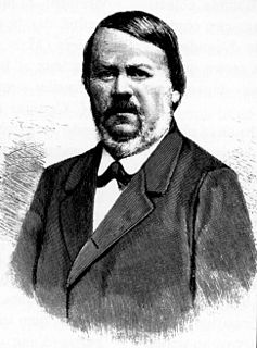
Franz Xaver Kraus was a German Catholic priest, and ecclesiastical and art historian.

Utscheid Place in Rhineland-Palatinate, Germany

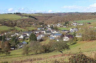
Utscheid is a municipality in the district of Bitburg-Prüm, in Rhineland-Palatinate, western Germany.

Johannes Mötsch is a German archivist and historian.

Römisch-Germanisches Zentralmuseum (Mainz) museum

The Römisch-Germanisches Zentralmuseum (RGZM), Leibniz Research Institute for Archaeology, is headquartered in Mainz. It is supported by the Federal Republic of Germany and its states and is a member of the Leibniz Association of German research institutions.

Master Gerhard German architect

Meister or Master Gerhard was the first master mason of Cologne Cathedral. He was also known as Gerhard von Rile or by the Latin version of his name, Meister Gerardus.

The Rudolf Virchow lecture was an annual public lecture delivered by an eminent researcher in the field of Palaeolithic archaeology in Neuwied (Germany). The lecture was held in honour of the German physician, archaeologist and politician Rudolf Virchow and his contributions to German archaeology, whilst at the same time also honouring the outstanding accomplishments of the invited speaker. The lecture series was discontinued after 2016, when a new price, THE HUMAN ROOTS AWARD was established to recognise significant achievements that have had an outstanding impact or great influence in understanding the archaeology of human behavioural evolution.

Niederbieber (Palaeolithic site)

The archaeological site Niederbieber is an important representative of the Federmesser culture. Dating to the end of the Pleistocene, the site is one of the most extensively excavated archaeological sites dating to the late Upper Palaeolithic. Finds and features are extraordinarily well preserved as the site was protected by fallout from the Laacher See volcanic eruption approximately 12,900 years ago. Comprehensive archaeological studies have provided a detailed view of activities and settlement dynamics of hunter-gatherer groups at the end of the ice age.

Schelenburg castle

The Schelenburg is a water castle in Schledehausen, municipality of Bissendorf, Lower Saxony.

Rheinisches Landesmuseum Trier museum of archaeology, antiquities and art in Trier, Weimarer Allee

The Rheinische Landesmuseum Trier is an archaeological museum in Trier, Germany. The collection stretches from prehistory through the Roman period, the Middle Ages to the Baroque era with a strong emphasis on the Roman past of Augusta Treverorum, Germany's oldest city. Its collections of (local) Roman sculptures, Roman mosaics and frescos are among the best in Germany.

Michael Matheus is a German historian.

Hermann Parzinger German archaeologist

Hermann Parzinger is a German historian who is a specialist in the culture of the Scythians. He has been president of the Prussian Cultural Heritage Foundation since 1 March 2008.

Lower Germanic Limes

The Lower Germanic Limes is the former frontier between the Roman province of Germania inferior and Germania Magna. The Lower Germanic Limes separated that part of the Rhineland left of the Rhine as well as the Netherlands, which was part of the Roman Empire, from the less tightly controlled regions east of the Rhine.

The Vogelheimer Klinge is an approximately 280,000 year old flint tool, discovered in 1926 during the construction of the Rhine-Herne Canal in Vogelheim, north of the city of Essen. In older publications it is also known as the Klingenschaber von Vogelheim. It was long considered to be the oldest accurately dated artifact in North Rhine-Westphalia and can be found in the de:Ruhr Museum.

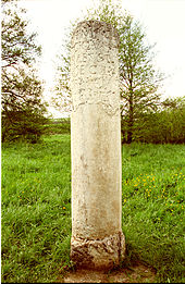
The Main Limes, also called the Nasser Limes, was built around 90 A. D. and, as part of the Upper Germanic-Rhaetian Limes, formed the frontier of the Roman Empire in the area between the present day villages of Großkrotzenburg and Bürgstadt. In this section the limes adjoined the River Main (Moenus), which forms a natural boundary for about 50 kilometres here, so "Main" refers to the river.

Holter Burg castle

The Holter Burg is the oldest castle site in the municipality of Bissendorf near Osnabrück in the German state of Lower Saxony. It is the ruin of a hill castle. It was the third hill castle in Osnabrück Land along with the Iburg and the Wittekindsburg near Rulle.

Wetterau Limes national heritage site

The Wetterau Limes is the name given in the field of historical research to that part of the Upper Germanic-Rhaetian Limes which enclosed the region that became known later as the Wetterau in the German state of Hesse.

Katzenberg Hillfort

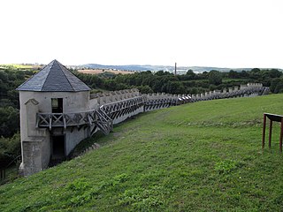
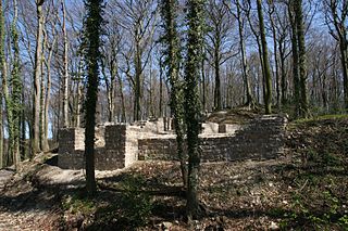
Katzenberg Hillfort is a Roman refuge fort near Mayen in Germany dating to the 4th century.

References

  1. Joseph Hagen: Die Römerstraßen der Rheinprovinz. Bonn 1931, p. 78
  2. Tabula Peutingeriana. Codex Vindobonensis 324, Österreichische Nationalbibliothek, Vienna. Commentary by E. Weber. Graz, 2004, ISBN   3-201-01793-0
  3. Konrat Ziegler et al. (ed.): Der Kleine Pauly. Lexikon der Antike. Munich, 1979, Col. 591
  4. e. g. Harm-Eckart Beier: Untersuchung zur Gestaltung des römischen Straßennetzes im Gebiet von Eifel, Hunsrück und Pfalz aus der Sicht des Straßenbauingenieurs. Dissertation, Goslar, 1971, p. 41
  5. Harm-Eckart Beier: Untersuchung zur Gestaltung des römischen Straßennetzes im Gebiet von Eifel, Hunsrück und Pfalz aus der Sicht des Straßenbauingenieurs. Dissertation, Goslar, 1971, p. 39
  6. Jeanne-Nora Andrikopoulou-Strack, Wolfgang Gaitzsch, Klaus Grewe, Susanne Jenter und Cornelius Ulbert: Neue Forschungen zu den Römerstraßen im Rheinland, in In: Thomas Otten, Hansgerd Hellenkemper, Jürgen Kunow, Michael Rind: Fundgeschichten – Archäologie in Nordrhein-Westfalen: Begleitbuch zur Landesausstellung NRW 2010, pp. 163 ff. (fortan Neue Forschungen)

Literature