History
The Roraima National Forest and Amazonas National Forest were created by President José Sarney in 1989. The Roraima National Forest was created by decree nº 97545 of 1 March 1989 and covered 2,664,685 hectares (6,584,580 acres) of the Amazon biome. This had the effect of dividing the territory of the Yanomami people into several separate areas. In 1990 three gold mining reserves were created within the Roraima National Forest. The Yanomami Indigenous Territory was demarcated in 1992 in the lead up to the Earth Summit in Rio de Janeiro. The indigenous territory was created on 25 May 1992 with an area of 9,664,975 hectares (23,882,670 acres), and it was thought that this territory completely covered the national forest area. This was followed by a vigorous international campaign in support of the Yanomami people. The gold mines were closed and the miners removed.
In an indigenous territory the indigenous people have the exclusive right of use according to their customs and traditions. Although technically the Roraima National Forest remained, exploitation of the forest would violate these rights. In 2001 IBAMA realized that 5% of the forest, or 142,000 hectares (350,000 acres), had been left out of the indigenous territory, and decided to repossess the unit. However, in the mid-1990s two settlements, Samaúma and Vila Nova, had taken 50,000 hectares (120,000 acres), leaving 92,000 hectares (230,000 acres) unclaimed. To regularize the situation, the boundaries were revised by law 12058 of 13 October 2009, and the forest now has an area of 167,268.74 hectares (413,330.1 acres). The resized national forest now excludes the indigenous territory.
Location
The Roraima National Forest is in the municipalities of Alto Alegre and Mucajaí of the state of Roraima. It adjoins the Yanomami Indigenous Territory to the west. Average annual rainfall is 2,000 millimetres (79 in). Temperatures range from 22 to 39 °C (72 to 102 °F) with an average of 24 °C (75 °F). The climate is tropical rainy in the eastern sector and tropical rainy monsoon on the west.
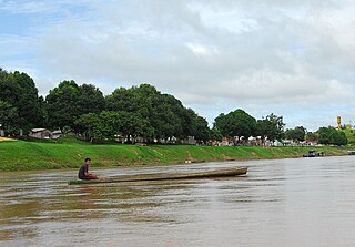
The terrain is undulating with hills that stand out from the surrounding land. The forest contains parts of the Mucajaí, Apiaú and Uraricoera sub-basins of the Branco River basin. In the Mucajaí sub-basin there is small farming and extensive livestock raising. There are also stretches of seasonal forest and dense rainforest in rugged terrain. The Apiaú is a right tributary of the Mucajaí and delimits the southern boundary of the national forest where it meets the Yanomami Indigenous Territory. A small part of the north of the national forest is in the Uraricoera basin, an area of extensive cattle ranching with some subsistence and semi-commercial farming.

Pico da Neblina National Park is a national park in the state of Amazonas in the north of Brazil, bordering on Venezuela. It overlaps with several indigenous territories, which creates tensions over land use, as does the military presence due to the border location. The park includes lowlands around the Rio Negro, partly flooded, and mountains that include the highest peak in Brazil, after which the park is named. The wide variety of physical environments supports great biodiversity, including several endangered species.

The Catimbau National Park is a national park in the state of Pernambuco, Brazil. It protects a semi-arid area of caatinga with sandstone caverns and caves in which prehistoric art has been found.

Serra da Mocidade National Park is a national park in the states of Amazonas and Roraima, Brazil.
Caracaraí Ecological Station is an ecological station in the state of Roraima, Brazil.
The Amazonas National Forest is a national forest in the state of Amazonas, Brazil.

Rio Novo National Park is a national park in the state of Pará, Brazil.

Itaituba I National Forest is a national forest in the state of Pará, Brazil.
Tapirapé-Aquiri National Forest is a national forest in the state of Pará, Brazil. It is surrounded by other protected areas, so has suffered relatively little from deforestation.
Mulata National Forest is a national forest in the state of Pará, Brazil.
The Aripuanã National Forest is a national forest in the state of Amazonas, Brazil. It supports sustainable forestry, and also protects the environment, supports scientific research and protects the sustainable lifestyle of the traditional inhabitants of the forest.
The Santa Rosa do Purus National Forest is a national forest in the state of Acre, Brazil.
The São Francisco National Forest is a national forest in the state of Acre, Brazil.

The Amapá National Forest is a national forest in the state of Amapá, Brazil. It supports sustainable exploitation of the natural resources in an area of Amazon rainforest in the Guiana Shield.
The Purus National Forest is a national forest in the state of Amazonas, Brazil. It surrounds the shamanic-Christian community of Céu do Mapiá.
The Mapiá-Inauini National Forest is a national forest in the state of Amazonas, Brazil.
The Lorena National Forest is a national forest in the state of São Paulo, Brazil. It protects a relatively small fragment of Atlantic Forest.

The Tefé National Forest is a national forest in Amazonas, Brazil. It protects a relatively well-preserved area of Amazon rainforest to the south of the town of Tefé on the Solimões River . The resident population, scattered in small communities along the rivers, are engaged in sustainable farming, fishing and extraction of forest products.
The Bom Futuro National Forest is a national forest in the state of Rondônia, Brazil. The forest has been subject to a massive invasion of loggers, ranchers and farmers.
The Balaio Indigenous Territory is an indigenous territory in the northwest of the state of Amazonas, Brazil. The territory is home to small numbers of people from several different ethnic groups of the Arawak and Tucano linguistic families.. It is in the Amazon biome. The territory overlaps with a national park and a biological reserve, both technically fully protected areas. Mining concessions before the territory was recognized have been disallowed.

The Yanomami Indigenous Territory is an indigenous territory in the states of Amazonas and Roraima, Brazil. It overlaps with several federal or state conservation units. It is home to Yanomami and Ye'kuana people. There are ongoing conflicts with an overlapping national forest in which mining was permitted.
This page is based on this
Wikipedia article Text is available under the
CC BY-SA 4.0 license; additional terms may apply.
Images, videos and audio are available under their respective licenses.
