
The Branco River is the principal affluent of the Rio Negro from the north.

The Guiana Shield is one of the three cratons of the South American Plate. It is a 1.7 billion-year-old Precambrian geological formation in northeast South America that forms a portion of the northern coast. The higher elevations on the shield are called the Guiana Highlands, which is where the table-like mountains called tepuis are found. The Guiana Highlands are also the source of some of the world's most well-known waterfalls such as Angel Falls, Kaieteur Falls and Cuquenan Falls.

Amazonas is a state of Brazil, located in the North Region in the north-western corner of the country. It is the largest Brazilian state by area and the ninth-largest country subdivision in the world. It is the largest country subdivision in South America, being greater than the areas of Chile, Paraguay, and Uruguay combined. Neighbouring states are Roraima, Pará, Mato Grosso, Rondônia, and Acre. It also borders the nations of Peru, Colombia and Venezuela. This includes the Departments of Amazonas, Vaupés and Guainía in Colombia, as well as the Amazonas state in Venezuela, and the Loreto Region in Peru.
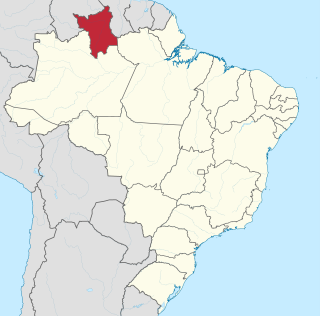
Roraima is one of the 26 states of Brazil. Located in the country's North Region, it is the northernmost and most geographically and logistically isolated state in Brazil. It is bordered by the state of Pará to the southeast, Amazonas to the south and west, Venezuela to the north and northwest, and Guyana to the east.
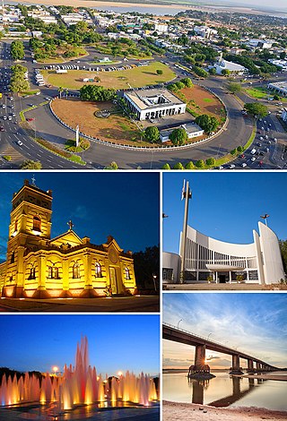
Boa Vista is the capital of the Brazilian state of Roraima. Situated on the western bank of the Branco River, the city lies 220 km (140 mi) from Brazil's border with Venezuela. It is the only Brazilian state capital located entirely north of the equator.

The Oyapock or Oiapoque is a 403-kilometre (250 mi) long river in South America that forms most of the border between the French overseas department of French Guiana and the Brazilian state of Amapá.
The Pacaraima or Pakaraima Mountains are a mountain range primarily in southwestern Guyana, and into northern Brazil and eastern Venezuela.

Pico da Neblina National Park is a national park in the state of Amazonas in the north of Brazil, bordering on Venezuela. It overlaps with several indigenous territories, which creates tensions over land use, as does the military presence due to the border location. The park includes lowlands around the Rio Negro, partly flooded, and mountains that include the highest peak in Brazil, after which the park is named. The wide variety of physical environments supports great biodiversity, including several endangered species.

Yanam, or Ninam, is a Yanomaman language spoken in Roraima, Brazil and southern Venezuela near the Mucajai, upper Uraricaá, and Paragua rivers.

Bonfim is a municipality located in the mideast of the state of Roraima in Brazil. Its population is 12,557 and its area is 8,095 km2. The city lies opposite the Takutu River from Lethem, Guyana. The Takutu River Bridge links Bonfim and Roraima with the town of Lethem and the Atlantic port of Georgetown, Guyana.

Caracaraí is a municipality located in the state of Roraima in Brazil. Its population is 22,283 and its area is 47,411 square kilometres (18,305 sq mi), making it the largest municipality in Roraima state. Caracaraí is located on the Branco River.
Arutani is a nearly extinct language spoken in Roraima, Brazil and in the Karum River area of Bolivar State, Venezuela. There are only around 6 speakers left.

The history of the territory that is now Roraima, a state at the extreme north of present-day Brazil is recent, but not thereby simple. Invaded numerous times by the various countries interested in the region, the seldom-visited Roraima aroused little interest on the part of the Portuguese, especially after the arrival of the royal family in Rio de Janeiro. Meanwhile, the territory became coveted by other countries, including England, the Netherlands, and, especially, Spain.
Maracá-Jipioca Ecological Station is an ecological station covering two islands about 5 kilometres (3.1 mi) offshore from Amapá, a municipality in Amapá state, Brazil. It protects an area of coastal mangroves and tropical rainforest.
Maracá Ecological Station is an ecological station in Boa Vista, Roraima, Brazil. It consists of a large island in the Uraricoera River that is covered by Amazon rainforest.
The Furo Santa Rosa is a river of Roraima state in northern Brazil. It is an anabranch - a diversionary channel - of the Uraricoera River; together they bound the Ilha de Maracá.

The Grão-Pará Ecological Station (Portuguese: Estação Ecológica Grão-Pará is a strictly protected ecological station in the state of Pará, Brazil. It is managed by the state of Pará. With 42,458 square kilometres of well-preserved Amazon rainforest, it is the largest fully protected tropical forest conservation unit in the world.
The Roraima National Forest is a national forest in the state of Roraima, Brazil.

Monte Roraima National Park is a national park in the state of Roraima, northern Brazil.
The Northern Amazon Ecological Corridor is a proposed ecological corridor connecting conservation units and indigenous territories in the north of the Amazon rainforest of Brazil.
