Rose Woods

Last updated
Rose Woods
(Wible's Woods during the commemorative era)
Federal soldier disembowelled by a shell- in the wheatfield Gettysburg 3July1863- detail LOC-LC-USZC4-1824.png
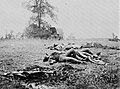
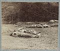
Soldier killed by artillery fire on the southwestern edge of[ verification needed ] the Rose Woods, near the Wheatfield. [1] [2]
Geography
Location Gettysburg National Military Park, Adams County, Pennsylvania
Coordinates 39°47′43″N77°14′38″W / 39.7952°N 77.2439°W / 39.7952; -77.2439 Coordinates: 39°47′43″N77°14′38″W / 39.7952°N 77.2439°W / 39.7952; -77.2439

Rose Woods is a Gettysburg Battlefield forested area that is an American Civil War site of the battle's Hood's Assault, McLaws' Assault, and McCandless' Advance. "Scene of the first line of Union defenses" [3] on the Battle of Gettysburg, Second Day; the 1st Texas Infantry and 3rd Arkansas Infantry Regiments attacked Ward's 2nd Brigade line in the woods. The last combat on the Battle of Gettysburg, Third Day, was "in the early evening. Colonel William McCandless's brigade of Pennsylvania Reserves advanced across the Wheatfield into Rose's Woods where they managed to inflict heavy losses on the 15th Georgia " which had failed to retreat to Warfield Ridge after Longstreet's Assault. [4] Two days later Timothy H. O'Sullivan photographed corpses moved for burial to the edge of Rose Woods [5] and which were subsequently reinterred in cemeteries.

De Trobriand Avenue and other Military Park roads provide access to the woods' battlefield monuments, and the woods' railbed for the 1894-1916 Gettysburg Electric Railway is a historic district contributing structure that is now a rail trail. Monuments in the woods include the 1890 Sixty-fourth New York Regiment Monument, and Wheat-field Park [6] in "Wible's Grove" was a commemorative era trolley park. [7] The trolley's overhead power line broke at Wible's Woods in 1900, [8] and the woods had the postbellum "William Wible's Quarry" [9] for Gettysburg Granite (cf. Rosensteel's Quarry north of the Round Top Museum). [10] In 2004, the archeological remains of the former trolley bridge in Rose Woods were named a historic district contributing structure. [11]

Related Research Articles

<span class="mw-page-title-main">Alexander Gardner (photographer)</span> Scottish photographer (1821–1882)

Alexander Gardner was a Scottish photographer who immigrated to the United States in 1856, where he began to work full-time in that profession. He is best known for his photographs of the American Civil War, U.S. President Abraham Lincoln, and of the conspirators and the execution of the participants in the Lincoln assassination plot.

<span class="mw-page-title-main">Devil's Den</span> Section of combat during the Second day of Gettysburg.

Devil's Den is a boulder-strewn hill on the south end of Houck's Ridge at Gettysburg Battlefield, once used by artillery and infantry on the second day of the 1863 Battle of Gettysburg during the American Civil War. A tourist attraction since the memorial association era, several boulders are worn from foot traffic and the site includes numerous cannon, memorials, and walkways, including a bridge spanning two boulders.

<span class="mw-page-title-main">Battle of Gettysburg, second day</span> Battle of the American Civil War

During the second day of the Battle of Gettysburg Confederate Gen. Robert E. Lee attempted to capitalize on his first day's success. His Army of Northern Virginia launched multiple attacks on the flanks of the Union Army of the Potomac, commanded by Maj. Gen. George G. Meade. The assaults were unsuccessful, and resulted in heavy casualties for both sides.

<span class="mw-page-title-main">Timothy H. O'Sullivan</span> American photographer (1840–1882)

Timothy H. O'Sullivan was a photographer widely known for his work related to the American Civil War and the Western United States.

The Ottawa Trojans were a Canadian football team based in Ottawa, Ontario and competed in the Ontario Rugby Football Union from 1943-1947. After winning the 1947 ORFU championship, the team would merge with the Ottawa Rough Riders in 1948.

Tamiami Park is a public urban park in metropolitan Miami, just south of the Modesto Maidique campus of Florida International University.

<span class="mw-page-title-main">Gettysburg Electric Railway</span>

The Gettysburg Electric Railway was a borough trolley that provided summer access to Gettysburg Battlefield visitor attractions such as military engagement areas, monuments, postbellum camps, and recreation areas. Despite the 1896 Supreme Court ruling under the Takings Clause against the railway, battlefield operations continued until 1916. The trolley generating plant was leased by the Electric Light, Heat, and Power Company of Gettysburg to supply streetlights and homes until electricity was imported from Hanover.

Bardstown (1952–1972) was an American Thoroughbred racehorse.

United States v. Gettysburg Electric Ry. Co., 160 U.S. 668 (1896), was a case to prevent trolley operations on the Gettysburg Battlefield. The dispute began in August 1891 when the Gettysburg Battlefield Memorial Association's board approved attorney Samuel Swope's motion to deny trolley right-of-way along GBMA roads. Despite the 1896 US Supreme Court ruling that the railway could be seized for historic preservation, as well as earlier legislative efforts to appropriate federal acquisition funds, create a War Department commission, and form the Gettysburg National Military Park; the trolley continued operations until obsolete in 1916.

<span class="mw-page-title-main">Gettysburg and Harrisburg Railroad</span>

The Gettysburg and Harrisburg Railroad was a railway line of Pennsylvania from Hunter's Run southward to Gettysburg in the 19th century. The north junction was with the South Mountain RR, and a crossing with the Hanover Junction, Hanover and Gettysburg Railroad's westward extension was at Gettysburg. The crossing also served as a junction for westbound trains to transfer southward across the Gettysburg Battlefield via the G. & H. R. R.'s Round Top Branch to the company's Little Round Top Park.

<span class="mw-page-title-main">Wheatfield Road</span>

The Wheatfield Road is a Gettysburg Battlefield crossroad from the Peach Orchard east-southeastward along the north side of The Wheatfield, north of the Valley of Death, and over the north foot of Little Round Top. In addition to modern tourist use, the road is notable for Battle of Gettysburg use and postbellum trolley use associated with the 1892-1896 US v. Gettysburg Electric Ry. case of the US Supreme Court.

Early's raids in Pennsylvania were a series of June military actions before the 1863 Battle of Gettysburg in which the Confederate forces of Major General Jubal Early conducted raids and military engagements from Chambersburg through Gettysburg to York.

<span class="mw-page-title-main">Yoel Lerner</span>

Yoel Lerner was a linguist, translator, educator, and Jewish terrorist, who was convicted of many crimes, including seeking to destroy the Dome of the Rock in Jerusalem.

Elections were held on November 8, 1982 in the Regional Municipality of Ottawa-Carleton. This page lists the election results for local mayors and councils of the RMOC in 1982.

References

  1. Frassanito's Early Photography at Gettysburg, p. 336 identifies the photograph as "Dead Confederate soldier in the field at the southwestern edge of the Rose Woods." (The Library of Congress identifies the photo site as The Wheatfield).
  2. Site first Identified by Gettysburg historian W. Frassanito "Gettysburg A Journey in Time" 1975
  3. Davis, W. G. "About what you are looking at…" (image description). Behind The Stonewall. JaTruck.com. Retrieved 2012-05-06.
  4. "National Park Service: Gettysburg Seminar Papers — The Third Day: The Fate Of A Nation, July 3, 1863". Archived from the original on 2013-12-15.
  5. "[Gettysburg, Pa. Confederate dead gathered for burial at the southwestern edge of the Rose woods, July 5, 1863]". Library of Congress . 1863.
  6. "Hoffer Sells Out" (Google News Archive). The Star and Sentinel . January 22, 1895. Retrieved 2011-02-24. Agreements with William Wible for the use of the Wheat-field Park, containing 25 acres, at the rate of $5 per day for each excursion to said park by the said Railway Company.
  7. 1893: https://news.google.com/newspapers?id=sqslAAAAIBAJ&sjid=XvwFAAAAIBAJ&pg=7010,628890&dq=wible's-woods&hl=en
    1895: https://news.google.com/newspapers?id=1P0yAAAAIBAJ&sjid=jAAGAAAAIBAJ&pg=1457%2C6999057
    1903: https://news.google.com/newspapers?id=opQzAAAAIBAJ&sjid=HOkFAAAAIBAJ&pg=4724,2881399&dq=wible's+grove&hl=en
  8. "The Pittsburgh Press - Google News Archive Search".
  9. "Licensed Battlefield Guide Rich Kohr: William Wible's Gettysburg Quarry". 21 January 2009.
  10. "Gettysburg Times - Google News Archive Search".
  11. "Electric Trolley Bed" . Retrieved 2011-03-02. [rail] trail along Plum Run at Devil's Den, runs N through Rose Farm & stops near The Loop. … Pair of cut stone block abutments over Rose Run, 5' high, 25' long & approx 10' apart.
  12. This site was identified by 2008. Letter from John Hesier, NPS Historian Gettysburg
  13. Site Identified by Gettysburg historian W. Frassanito "Gettysburg A Journey in Time" 1975
  14. Site Identified by Gettysburg historian W. Frassanito "Gettysburg A Journey in Time" 1975
  15. Site Identified by Gettysburg historian W. Frassanito "Gettysburg A Journey in Time" 1975
  16. Letter from John Hesier, NPS Historian Gettysburg
  17. Site Identified by Gettysburg historian W. Frassanito "Gettysburg A Journey in Time" 1975
  18. Site Identified by Gettysburg historian W. Frassanito "Gettysburg A Journey in Time" 1975
  19. Site Identified by Gettysburg historian W. Frassanito "Gettysburg A Journey in Time" 1975