
The Fraser Valley is a geographical region in southwestern British Columbia, Canada and northwestern Washington State. It starts just west of Hope in a narrow valley encompassing the Fraser River and ends at the Pacific Ocean stretching from the North Shore Mountains, opposite the city of Vancouver BC, to just south of Bellingham, Washington.

Chilliwack is a city of about 100,000 people and 261 km2 (100 sq mi) in the Canadian province of British Columbia. It is located about 100 km (62 mi) east of the City of Vancouver in the Fraser Valley. The enumerated population is 93,203 in the city and 113,767 in the greater metropolitan area.

Hope is a district municipality at the confluence of the Fraser and Coquihalla rivers in the province of British Columbia, Canada. Hope is at the eastern end of both the Fraser Valley and the Lower Mainland region, and is at the southern end of the Fraser Canyon. To the east, over the Cascade Mountains, is the Interior region, beginning with the Similkameen Country on the farther side of the Allison Pass in Manning Park. Located 154 kilometres (96 mi) east of Vancouver, Hope is at the southern terminus of the Coquihalla Highway and the western terminus of the Crowsnest Highway, locally known as the Hope-Princeton, where they merge with the Trans-Canada Highway. Hope is at the eastern terminus of Highway 7. As it lies at the eastern end of the Fraser Valley in the windward Cascade foothills, the town gets very high amounts of rain and cloud cover – particularly throughout the autumn and winter.

Bridal Veil Falls Provincial Park is a BC Park situated on the Trans-Canada Highway just east of Rosedale, British Columbia, Canada, within of the City of Chilliwack. The community of Bridal Falls is located adjacent to the falls and park, as well as the interchange between the Trans-Canada and BC Highway 9, offering a variety of highway-based tourism services. Access to the falls requires a short hike from the parking lot and well-groomed trails, taking most groups 15-25 minutes.

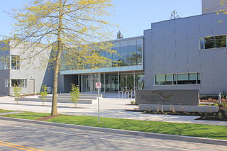
The University of the Fraser Valley (UFV), formerly known as University College of the Fraser Valley and Fraser Valley College, is a public university with campuses in Abbotsford, Chilliwack, Mission and Hope, British Columbia, Canada. Founded in 1974 as Fraser Valley College, it was a response to the need for expanded vocational training in the communities of the Fraser Valley. In 1991, it became a university college, with degree-granting status. As the University College of the Fraser Valley, it grew rapidly, becoming one of the largest university colleges in Canada.

The Fraser Valley Regional District (FVRD) is a regional district in British Columbia, Canada. Its headquarters are in the city of Chilliwack. The FVRD covers an area of 13,361.74 km2 (5,159 sq mi). It was created in 1995 by an amalgamation of the Fraser-Cheam Regional District and Central Fraser Valley Regional District and the portion of the Dewdney-Alouette Regional District from and including the District of Mission eastwards.

Chilliwack-Kent is a former provincial electoral district for the Legislative Assembly of British Columbia, Canada that existed from 2001 to 2009 and again from 2017 to 2024.
Bridal Falls is a community in the Fraser Valley of British Columbia, located east of Rosedale and immediately adjacent to the on-ramps for the Agassiz-Rosedale Bridge, which connects the Trans-Canada Highway at Bridal Falls to Agassiz, on Highway 9.

The District of Kent is a district municipality located 116 kilometres (72 mi) east of Vancouver, British Columbia. Part of the Fraser Valley Regional District, Kent consists of several communities, the largest and most well-known being Agassiz—the only town in the municipality—Harrison Mills, Kilby, Mount Woodside, Kent Prairie, Sea Bird Island and Ruby Creek. Included within the municipality's boundaries are several separately-governed Indian reserves, including the Seabird Island First Nation's reserves on and around the island of the same name.

Agassiz is a small community located in the Eastern Fraser Valley region of British Columbia, Canada, about 97 kilometres east of Vancouver and 24 kilometres north-east of the city of Chilliwack. Agassiz is the only town centre within the jurisdiction of the District Municipality of Kent. The majority of Kent's population resides in the Agassiz area.
Chilliwack Central Elementary Community is a public elementary school in Chilliwack, British Columbia part of School District 33 Chilliwack.

CIVL-FM is a Canadian radio station located at the University of the Fraser Valley in Abbotsford, British Columbia. More commonly known as CIVL Radio, the station serves the Fraser Valley Regional District, specifically the surrounding communities of UFV in Abbotsford, Chilliwack and Mission.
Area Support Unit Chilliwack is a Canadian Forces facility located in Chilliwack, British Columbia.
Harrison Hill (622m) is a small mountain located at the confluence of the Harrison and Fraser Rivers in the Lower Mainland region of British Columbia, Canada. Harrison Knob (~225m) is a prominent shoulder to the east of the main peak of Harrison Hill. Harrison Hill and Harrison Knob are on the north side of the Fraser opposite Chilliwack, Harrison Knob overlooks the confluence directly, Harrison Hill itself separates the Fraser downstream from that confluence and overlooks on its north Harrison Bay, a large, shallow lake-like sidewater of the Harrison River, while at its western foot is the community of Lake Errock. At its eastern foot, just below Harrison Knob, had been the formerly large sawmill town of Harrison Mills, which spanned both sides of the Harrison and was served by the mainline of the Canadian Pacific Railway, which runs along the north side of the mountain's base. The Indian Reserves of the Scowlitz First Nation are at the western end of Harrison Bay and at its outlet at its eastern end, while the reserve of the Chehalis First Nation is along its north shore, and Kilby is on its east shore.
The New Westminster Land District is one of 59 land districts of British Columbia, Canada, which are the underlying cadastral divisions of that province, created with rest of those on Mainland British Columbia via the Lands Act of the Colony of British Columbia in 1860. The British Columbia government's BC Names system, a subdivision of GeoBC, defines a land district as "a territorial division with legally defined boundaries for administrative purposes". All land titles and surveys use the Land District system as the primary point of reference, and entries in BC Names for placenames and geographical objects are so listed.
The Leq'á:mel First Nation, formerly known as Lakahahmen First Nation, is a First Nations band government whose community and offices are located in the area near Deroche, British Columbia in the Fraser Valley region in Canada, about 12 kilometres east of the District of Mission. They are a member government of the Sto:lo Nation Chiefs Council, which is one of two tribal councils of the Sto:lo.
Atchelitz is a rural community within the City of Chilliwack in the Eastern Fraser Valley region of British Columbia, Canada. It is located southwest of the city core, to the north of the Vedder Canal.
Aitchelitch 9, a.k.a. Aitchelitch Indian Reserve No. 9, is an Indian Reserve within the City of Chilliwack, British Columbia, Canada, in the Eastern Fraser Valley of the province's Lower Mainland region. It is located two and a half miles southwest of downtown Chilliwack. It is the home reserve and under the governance of the Aitchelitz First Nation.
Chilliwack is a city made up of several amalgamated villages and communities. The urban core has a decidedly north–south axis bisected by the Trans-Canada Highway. The city is bounded in north by the Fraser River, in the east by the Eastern Hillsides, in the south by the Canada-U.S. border, and in the west by the Vedder Canal.
Canada Education Park (CEP) is located on the southside of Chilliwack at the former site of the Canadian army base called CFB Chilliwack. It is home to learning institutions including University of the Fraser Valley, Justice Institute of BC, and RCMP Pacific Region Training Centre.
