Related Research Articles
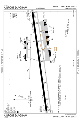
Eagle County Regional Airport is in Gypsum, Colorado, United States, 4 miles from Eagle and 37 miles from Vail. It covers 632 acres (256 ha) and has one runway. The History Channel rated Eagle County Regional Airport as #8 on its list of Most Extreme Airports in July 2010 due to the elevation, weather, approach through mountainous terrain and challenging departure procedures. In 2008–09 the airport completed a runway repaving and extension project, increasing the runway length to 9,000 feet.
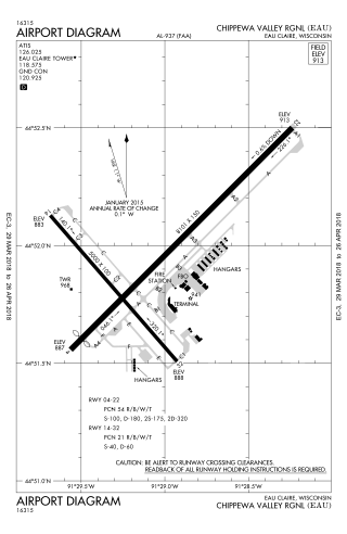
Chippewa Valley Regional Airport is a public use airport in Chippewa County, Wisconsin, United States. The airport is owned by Eau Claire county and is located 3 nautical miles ) north of the central business district of the city of Eau Claire, Wisconsin.
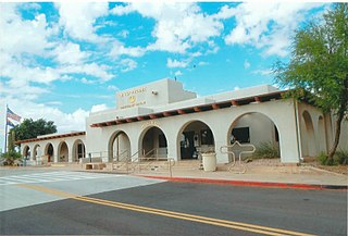
Phoenix Deer Valley Airport is a public airport 17 miles north of Phoenix, in Maricopa County, Arizona, United States. It is owned by the City of Phoenix. The FAA's National Plan of Integrated Airport Systems for 2009–2013 categorized it as a reliever airport for Phoenix Sky Harbor International Airport.
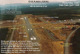
Gulkana Airport is a state owned, public use airport located four nautical miles northeast of the central business district of Gulkana, in the Valdez-Cordova Census Area of the U.S. state of Alaska. It is also and five miles (8 km) northeast of Glenallen. Scheduled passenger service is subsidized by the Essential Air Service program.
May Creek Airport is a state owned, public use airport located one nautical mile (2 km) south of the central business district of May Creek, in the Valdez-Cordova Census Area of the U.S. state of Alaska. Scheduled passenger service is subsidized by the Essential Air Service program.
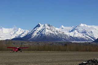
McCarthy Airport is a state owned, public use airport located one nautical mile (2 km) northeast of the central business district of McCarthy, in the Valdez-Cordova Census Area of the U.S. state of Alaska. Scheduled passenger service is subsidized by the Essential Air Service program.

Illinois Valley Airport is a county-owned public-use airport located four miles (6.4 km) southwest of the central business district of Cave Junction, a city in Josephine County, Oregon, United States.
Chester County G. O. Carlson Airport is a public airport two miles (3 km) west of Coatesville, in Chester County, Pennsylvania. It is owned by the Chester County Area Airport Authority.
Kaltag Airport is a state-owned public-use airport located one nautical mile (1.85 km) southwest of the central business district of Kaltag, a city in the Yukon-Koyukuk Census Area of the U.S. state of Alaska.
Wheeling Ohio County Airport is a public airport serving Wheeling and Ohio County, West Virginia, United States. It is eight miles (13 km) northeast of downtown Wheeling and is owned by the Ohio County Commission.
Beaver County Airport or is a county-owned public airport three miles northwest of Beaver Falls, in Beaver County, Pennsylvania.
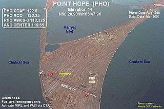
Point Hope Airport is a state-owned public-use airport located two miles (3 km) southwest of the central business district of Point Hope, a city in the North Slope Borough of the U.S. state of Alaska. Point Hope is located in the Lisburne Peninsula, on the Chukchi Sea coast.

Butler–Choctaw County Airport is a city-owned public-use airport located 5 nautical miles (9 km) northeast of the central business district of Butler, a city in Choctaw County, Alabama, United States. According to the FAA's National Plan of Integrated Airport Systems for 2009–2013, it is categorized as a general aviation facility.

Courtland Airport is a public-use airport located two nautical miles northeast of the central business district of Courtland, a town in Lawrence County, Alabama, United States. It is owned by the Lawrence County Commission and was formerly known as Lawrence County Airport.
Shungnak Airport is a state-owned public-use airport located in Shungnak, a city in the Northwest Arctic of the U.S. state of Alaska.
Teller Airport is a state-owned public-use airport located two nautical miles (4 km) south of the central business district of Teller, a city in the Nome Census Area of the U.S. state of Alaska.
St. Michael Airport is a state-owned, public-use airport located two nautical miles (4 km) west of the central business district of St. Michael, a city in the Nome Census Area of the U.S. state of Alaska.

Kotlik Airport is a state-owned public-use airport located one nautical mile (1.85 km) west of the central business district of Kotlik, a city in the Kusilvak Census Area of the U.S. state of Alaska.

Big Lake Airport is a state-owned public-use airport located one nautical mile (1.8 km) southeast of the central business district of Big Lake, in the Matanuska-Susitna Borough of the U.S. state of Alaska.
Nome City Field is a state-owned public-use airport located one nautical mile north of the central business district of Nome, a city in the Nome Census Area of the U.S. state of Alaska.