Rovensko pod Troskami | |
---|---|
![]() Town hall | |
Coordinates: 50°32′7″N15°15′34″E / 50.53528°N 15.25944°E | |
Country | ![]() |
Region | Liberec |
District | Semily |
First mentioned | 1371 |
Government | |
• Mayor | Jiřina Bláhová |
Area | |
• Total | 12.81 km2 (4.95 sq mi) |
Elevation | 306 m (1,004 ft) |
Population (2025-01-01) [1] | |
• Total | 1,371 |
• Density | 110/km2 (280/sq mi) |
Time zone | UTC+1 (CET) |
• Summer (DST) | UTC+2 (CEST) |
Postal code | 512 63 |
Website | www |
Rovensko pod Troskami is a town in Semily District in the Liberec Region of the Czech Republic. It has about 1,400 inhabitants.
Rovensko pod Troskami consists of six municipal parts (in brackets population according to the 2021 census): [2]
Rovensko pod Troskami is located about 27 kilometres (17 mi) southeast of Liberec. It lies mostly in the Jičín Uplands, only the eastern part of the municipal territory extends into the Ještěd–Kozákov Ridge. The highest point is the hill Kámen at 440 m (1,440 ft) above sea level. The Veselka Stream flows through the town.
The first written mention of Rovensko pod Troskami is from 1371. [3]
|
|
| ||||||||||||||||||||||||||||||||||||||||||||||||||||||
Source: Censuses [4] [5] |
Rovensko pod Troskami is located on the railway line Hradec Králové–Turnov. [6]
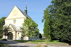
The main landmark of the town is the Church of Saint Wenceslaus. The originally Gothic church was rebuilt in the Baroque style in 1724, later it was modified in the Neo-Gothic style. Next to the church stands a separate wooden bell tower, which dates from 1630. Its rarity is three early Baroque bells, hung upside down. [7]