
Start Point is a point marking the northwest end of Byers Peninsula, Livingston Island in the South Shetland Islands, Antarctica and forming the southwest side of the entrance to Svishtov Cove and the northeast side of the entrance to the New Plymouth bay. Discovered by Edward Bransfield in January 1820, and so named by him because of its resemblance to a point on the south coast of England by the same name and because it was the place where his operations began.
Byers Peninsula is a mainly ice-free peninsula forming the west end of Livingston Island in the South Shetland Islands of Antarctica. It occupies 60 km2 (23 sq mi), borders Ivanov Beach to the northeast and is separated from Rotch Dome on the east by the ridge of Urvich Wall. The peninsula features more than 60 meltwater streams and as many lakes, notably Midge Lake, Limnopolar Lake and Basalt Lake. Byers Peninsula has a regime of special environmental protection under the Antarctic Treaty System and requires a permit to enter.
Devils Point is a point marking the southwest extremity of Byers Peninsula, Livingston Island in the South Shetland Islands, Antarctica and forming the southeast side of the entrance to Osogovo Bay and the west side of the entrance to Raskuporis Cove. The point is separated from Vardim Rocks to the south by Hell Gates. Lucifer Crags, a rocky bluff rising to 81 m at the south extremity of President Beaches, surmount Devils Point on the southwest, Acheron Lake on the northeast and Siren Lake on the east-southeast. The area was visited by early 19th century sealers.

Bilyar Point is a rounded ice-free point on Ivanov Beach in western Livingston Island, the South Shetland Islands in Antarctica projecting 350 m into Barclay Bay. Situated 3 km southwest of Rowe Point, northwest of Rotch Dome, 1.7 km northeast of Nedelya Point and 4.5 km east-northeast of Lair Point.
Urvich Wall is the narrow ice-free and crescent-shaped ridge rising to 121 m on Livingston Island in the South Shetland Islands, Antarctica and bounded by Nedelya Point to the north and Rish Point to the southeast. The ridge is 6.7 km long and up to 400 m wide, and separates Byers Peninsula to the west from Rotch Dome to the east. It surmounts Oread Lake, Montemno Lake and Bedek Stream on the west.
Isbul Point is a narrow rocky point projecting 600 m from the coast of Ray Promontory into Svishtov Cove in the northwest extremity of Byers Peninsula, Livingston Island in the South Shetland Islands, Antarctica. It is situated 750 m east-northeast of Start Point, 1.46 km southwest of Essex Point and 1.23 km west-southwest of Kardzhali Point. Forming the east side of the entrance to Belene Cove.
Dospey Heights are the ice-free heights on Ray Promontory in the northwestern part of Byers Peninsula on Livingston Island in the South Shetland Islands, Antarctica. Extending 6 km southeastwards from Essex Point and Start Point, and 2.6 km wide. Rising to 265 m at Start Hill.
Tsamblak Hill is a rocky hill trending 900 m in north–south direction, 450 m wide and rising to 113 m in eastern Byers Peninsula on Livingston Island in the South Shetland Islands, Antarctica. It surmounts Bedek Stream on the east, Feya Tarn on the south-southwest and Eridanus Stream on the west.
Nedelya Point is a sharp ice-free point at the southwest extremity of Ivanov Beach on the north coast of Livingston Island in the South Shetland Islands, Antarctica, projecting 300 m into Barclay Bay. It is linked by a chain of rocks to Cutler Stack, located 310 m to the north-northwest. The feature was visited by a field party from the British base camp Station P during the summer season 1957/58. It is part of the Antarctic Specially Protected Area ASPA 126 Byers Peninsula, situated in one of its two restricted zones.
Rotch Dome is the sloping ice dome rising to 360 m immediately east of Byers Peninsula, and between Barclay Bay and Walker Bay in Livingston Island, South Shetland Islands, Antarctica. It is bounded by Urvich Wall to the west, surmounting Ivanov Beach to the northwest, Etar Snowfield to the north-northeast and Verila Glacier to the east-northeast, and is linked by a saddle to Casanovas Peak to the northeast.
Essex Point is a point at the northwest end of Byers Peninsula, Livingston Island in the South Shetland Islands, Antarctica. It forms the west side of the entrance to Barclay Bay and the northeast side of the entrance to Svishtov Cove, and is surmounted by Drong Hill.

Ray Promontory is the 7 km long and 2.8 km wide promontory lying between Barclay Bay and the New Plymouth sound, and forming the northwest part of Byers Peninsula, Livingston Island in the South Shetland Islands, Antarctica ending up in Start Point and Essex Point. The promontory's interior is mostly occupied by Dospey Heights.
Window Island is a small ice-free island off the north coast of Ray Promontory in the northwest of Byers Peninsula, Livingston Island in the South Shetland Islands, Antarctica. The island has a surface area of 23 hectares and rises to 72 m (236 ft). It was known to the early 19th century sealers operating on Byers Peninsula.
Lair Point is a point projecting 570 m into Barclay Bay from Robbery Beaches on Byers Peninsula, Livingston Island in the South Shetland Islands, Antarctica and forming the east side of the entrance to Kukuzel Cove. Dominated by Lair Hill.
Ocoa Point is a steep headland backed by raised beach terraces at the head of New Plymouth harbour in Byers Peninsula, Livingston Island in the South Shetland Islands, Antarctica. The area was visited by 19th century sealers.
Rame Bluff is a rocky headland on the southwest side of Ray Promontory formed by an offshoot of Dulo Hill, and marking the northern limit of President Beaches on Byers Peninsula, Livingston Island in the South Shetland Islands, Antarctica. The area was visited by 19th century sealers.
Enrique Hill is the ice-free hill rising to 156 m in Dospey Heights on the Ray Promontory of Byers Peninsula, Livingston Island in the South Shetland Islands, Antarctica. It surmounts Barclay Bay to the east and northeast, and Diomedes Lake on the southeast

Vodoley Rock is the rock extending 220 m (720 ft) in northwest–southeast direction and 110 m (360 ft) wide in Barclay Bay on the west side of Ioannes Paulus II Peninsula on Livingston Island in the South Shetland Islands, Antarctica. The area was visited by early 19th century sealers operating on nearby Byers Peninsula and Cape Shirreff.
Ivanov Beach is a mostly ice-free beach on the Drake Passage stretching 5 km (3.1 mi) in southwest–northeast direction on the southeast coast of Barclay Bay in western Livingston Island, South Shetland Islands in Antarctica. It extends to Nedelya Point and Byers Peninsula on the southwest, Rowe Point and Etar Snowfield on the northeast, and the slopes of Rotch Dome on the southeast. Its ice-free area is ca. 144 hectares.
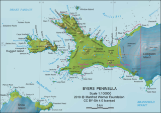
Mneme Lake is the oval-shaped 220 m long in southwest–northeast direction and 85 m wide lake on the northwest coast of Livingston Island in the South Shetland Islands, Antarctica. It has a surface area of 1.3 ha and is separated from the waters of Barclay Bay by a 12 to 40 m wide strip of land. The lake and its vicinity lie in a restricted zone of scientific importance to Antarctic microbiology, part of the Antarctic Specially Protected Area Byers Peninsula.


