
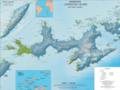
Etar Snowfield is a roughly crescent-shaped snowfield on western Livingston Island in the South Shetland Islands, Antarctica situated west of Urdoviza, Medven and Berkovitsa Glaciers, northwest of Verila Glacier, east of Ivanov Beach and south of Gerlovo Beach. It drains the west slopes of Oryahovo Heights and the north slopes of Rotch Dome, and flows into Barclay Bay between Mercury Bluff and Rowe Point. The feature extends 5 km (3 mi) inland, and 15 km (9 mi) in south-southwest to north-northeast direction.
Verila Glacier on Livingston Island in the South Shetland Islands, Antarctica is situated southeast of southern Etar Snowfield, southwest of Berkovitsa and Tundzha Glaciers, and west of Kamchiya Glacier. It is bounded by Rotch Dome to the west, Casanovas Peak and Snow Peak to the north, and Ustra Peak to the southeast. The glacier is roughly crescent-shaped, extending 7 nautical miles in an east-west direction and 2 nautical miles in a north-south direction, and drains southwards into Walker Bay, Bransfield Strait between John Beach and Liverpool Beach at Hannah Point. The glacier's bedrock is connected to Kaliman Island in Walker Bay by a 600 m long moraine tombolo. The area was visited by 19th century British and American sealers.

Start Point is a point marking the northwest end of Byers Peninsula, Livingston Island in the South Shetland Islands, Antarctica and forming the southwest side of the entrance to Svishtov Cove and the northeast side of the entrance to the New Plymouth bay. Discovered by Edward Bransfield in January 1820, and so named by him because of its resemblance to a point on the south coast of England by the same name and because it was the place where his operations began.
Hannah Point is a point on the south coast of Livingston Island in the South Shetland Islands, Antarctica. It forms the east side of the entrance to Walker Bay and the west side of the entrance to South Bay. Surmounted by Ustra Peak to the north, with Liverpool Beach extending between the peak and the tip of Hannah Point. Ice-free area ca. 122 hectares.
President Beaches is a series of beaches which extend for 6 nautical miles (11 km) along the broad western end of Byers Peninsula, Livingston Island in the South Shetland Islands, Antarctica between Start Point to the north and Devils Point to the south.
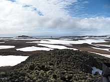
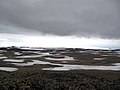
Byers Peninsula is a mainly ice-free peninsula forming the west end of Livingston Island in the South Shetland Islands of Antarctica. It occupies 60 km2 (23 sq mi), borders Ivanov Beach to the northeast and is separated from Rotch Dome on the east by the ridge of Urvich Wall. The peninsula features more than 60 meltwater streams and as many lakes, notably Midge Lake, Limnopolar Lake and Basalt Lake. Byers Peninsula has a regime of special environmental protection under the Antarctic Treaty System and requires a permit to enter.
New Plymouth is a bay bordered by an extensive line of beaches, lying south of Start Point and between Rugged Island and the west end of Livingston Island in the South Shetland Islands, Antarctica.
Devils Point is a point marking the southwest extremity of Byers Peninsula, Livingston Island in the South Shetland Islands, Antarctica and forming the southeast side of the entrance to Osogovo Bay and the west side of the entrance to Raskuporis Cove. The point is separated from Vardim Rocks to the south by Hell Gates. Lucifer Crags, a rocky bluff rising to 81 m at the south extremity of President Beaches, surmount Devils Point on the southwest, Acheron Lake on the northeast and Siren Lake on the east-southeast. The area was visited by early 19th century sealers.
Bilyar Point is a rounded ice-free point on Ivanov Beach in western Livingston Island, the South Shetland Islands in Antarctica projecting 350 m into Barclay Bay. Situated 3 km southwest of Rowe Point, northwest of Rotch Dome, 1.7 km northeast of Nedelya Point and 4.5 km east-northeast of Lair Point.
Urvich Wall is the narrow ice-free and crescent-shaped ridge rising to 121 m on Livingston Island in the South Shetland Islands, Antarctica and bounded by Nedelya Point to the north and Rish Point to the southeast. The ridge is 6.7 km long and up to 400 m wide, and separates Byers Peninsula to the west from Rotch Dome to the east. It surmounts Oread Lake, Montemno Lake and Bedek Stream on the west.
Tsamblak Hill is a rocky hill trending 900 m in north–south direction, 450 m wide and rising to 113 m in eastern Byers Peninsula on Livingston Island in the South Shetland Islands, Antarctica. It surmounts Bedek Stream on the east, Feya Tarn on the south-southwest and Eridanus Stream on the west.
Nedelya Point is a sharp ice-free point at the southwest extremity of Ivanov Beach on the north coast of Livingston Island in the South Shetland Islands, Antarctica, projecting 300 m into Barclay Bay. It is linked by a chain of rocks to Cutler Stack, located 310 m to the north-northwest. The feature was visited by a field party from the British base camp Station P during the summer season 1957/58. It is part of the Antarctic Specially Protected Area ASPA 126 Byers Peninsula, situated in one of its two restricted zones.
Rotch Dome is the sloping ice dome rising to 360 m immediately east of Byers Peninsula, and between Barclay Bay and Walker Bay in Livingston Island, South Shetland Islands, Antarctica. It is bounded by Urvich Wall to the west, surmounting Ivanov Beach to the northwest, Etar Snowfield to the north-northeast and Verila Glacier to the east-northeast, and is linked by a saddle to Casanovas Peak to the northeast.
Essex Point is a point at the northwest end of Byers Peninsula, Livingston Island in the South Shetland Islands, Antarctica. It forms the west side of the entrance to Barclay Bay and the northeast side of the entrance to Svishtov Cove, and is surmounted by Drong Hill.
Window Island is a small ice-free island off the north coast of Ray Promontory in the northwest of Byers Peninsula, Livingston Island in the South Shetland Islands, Antarctica. The island has a surface area of 23 hectares and rises to 72 m (236 ft). It was known to the early 19th century sealers operating on Byers Peninsula.
South Beaches are the beaches extending along the south side of Byers Peninsula, Livingston Island in the South Shetland Islands, Antarctica between Devils Point to the west and Rish Point to the east. The beaches were visited by 19th century sealers.
Villard Point is a point projecting 500 m into Barclay Bay from Robbery Beaches on Byers Peninsula, Livingston Island in the South Shetland Islands, Antarctica and forming the east side of the entrance to Baba Tonka Cove and the west side of the entrance to Kukuzel Cove.
Lair Point is a point projecting 570 m into Barclay Bay from Robbery Beaches on Byers Peninsula, Livingston Island in the South Shetland Islands, Antarctica and forming the east side of the entrance to Kukuzel Cove. Dominated by Lair Hill.

Station P was a British base camp at the head of Mateev Cove on the east side of Hannah Point, Livingston Island in the South Shetland Islands, Antarctica that supported survey, geology and biology field work from 29 December 1957 until 15 March 1958. The camp was occupied by a six-member team led by Hugh Simpson. The surveyed areas included parts of Byers Peninsula, Elephant Point, Ioannes Paulus II Peninsula and Hurd Peninsula.
Ivanov Beach is a mostly ice-free beach on the Drake Passage stretching 5 km (3.1 mi) in southwest–northeast direction on the southeast coast of Barclay Bay in western Livingston Island, South Shetland Islands in Antarctica. It extends to Nedelya Point and Byers Peninsula on the southwest, Rowe Point and Etar Snowfield on the northeast, and the slopes of Rotch Dome on the southeast. Its ice-free area is ca. 144 hectares.


