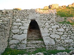
Royal Palace of Ugarit

Last updated
Royal Palace of Ugarit
Ugarit Corbel.jpg
A postern gate of the Royal Palace of Ugarit
Location Ugarit, northwestern Syria
Coordinates 35°36′06″N35°46′59″E / 35.601719°N 35.783008°E / 35.601719; 35.783008
TypeRoyal residence
Part ofAcropolis of Ugarit
Length110 metres (360 ft)
Width75 metres (246 ft)
Area6,500 square metres (70,000 sq ft)
History
Material Ashlar stone, wooden crossbeams, plaster
Foundedc.15th – c.13th-century BC
Abandonedc.1180 BC
Periods Bronze Age
Cultures Canaanite
Associated with Niqmaddu II, Niqmepa, Ibiranu, Ammurapi, Ahatmilku
Site notes
Excavation dates1929–1939
1948–1955
Archaeologists Claude F. A. Schaeffer
ConditionPartial restoration
Public accessyes

The Royal Palace of Ugarit was the royal residence of the rulers of the ancient kingdom of Ugarit on the Mediterranean coast of Syria. The palace was excavated with the rest of the city from the 1930s by French archaeologist Claude F. A. Schaeffer and is considered one of the most important finds made at Ugarit.

Contents

Overview

Layout

The palace, located in the north-west corner of the city, spanned an area of 6,500 square metres (70,000 sq ft). The palace area was surrounded by a fortified wall that dates back to the 15th-century BC. The palace's main gate was protected by an array of towers, dubbed the Fortress, with 5 metres (16 ft) thick walls. [1]

The palace consisted of ninety rooms divided between two floors. The rooms were built around four large courtyards and four smaller ones. The western end of the palace had a large garden. In the north side of the palace, three underground burial chambers were constructed. The ground floor was used for administrative purposes and included offices, archives, storage and staff dwellings. The second floor housed the family quarters, and was accessed through twelve staircases. [1] The palace had three entrances: the main gate on the northwest near the Fortress, and two smaller entrances in the northeast and the southwest. [2]

Architecture

The palace was built in four major stages between the 15th and 13th-century BC. [1] It was built out of ashlar stone blocks and wooden crossbeams, with a thick coat of plain plaster covering the walls. [2] The fortified wall, which dates back to the 15th-century BC, was built with packed stones at the bottom and had an outward slope of 45 degrees. [1]

The layout is typical of palaces of the Eastern Mediterranean and the Ancient Near East. The irregular outline of the palace and the asymmetrical layout are evidence of constant additions and alterations. The burial chambers had corbelled vaults which show a connection with Hittite and Mycenaean architecture. [1]

Excavation

After the chance discovery of Ugarit by local peasants in 1929, French archaeologist, Claude F. A. Schaeffer led ten excavation campaigns at the site which only covered the northwest corner. Excavations stopped with the advent of World War II and only resumed in 1948. Between 1950 and 1955 Schaeffer led concentrated excavations at the palace which unearthed a vast corpus of tablets and artefacts. [3]

Artifacts

Objects found at the site included ivory carvings, furniture, stone stelae, and figurines. [2] An Egyptian-made alabaster vase was found, partially damaged. The ornamentation on the vase depicts the wedding of Ugarit King Niqmaddu II to an upper-class Egyptian woman. [4] Other vases of Egyptian origin found at the site include ones carrying the cartouches of Egyptian Kings Ramesses II and Horemheb. [5]

Tablets

Eight archives of cuneiform tablets were excavated in the palace complex. The corpus included more than a 1,000 tablets written mostly in Akkadian and Ugaritic. A small corpus of Hurrian and Hittite tablets were discovered as well. [6] The tablets were organized by subject in different wings. They included administrative reports about Ugarit's dependencies, judicial records, official correspondence with other rulers and even practice tablets that new scribes used to learn writing. [7] The tablets included about 36 hymns, known as the Hurrian songs. [8]

Related Research Articles

<span class="mw-page-title-main">Hittites</span> Ancient Anatolian people of Kussara

The Hittites were an Anatolian Indo-European people who formed one of the first major civilizations of Bronze Age West Asia. Possibly originating from beyond the Black Sea, they settled in modern day Turkey in the early 2nd millennium BC. The Hittites formed a series of polities in north-central Anatolia, including the kingdom of Kussara, the Kanesh or Nesha kingdom, and an empire centered on Hattusa. Known in modern times as the Hittite Empire, it reached its height during the mid-14th century BC under Šuppiluliuma I, when it encompassed most of Anatolia and parts of the northern Levant and Upper Mesopotamia.

<span class="mw-page-title-main">15th century BC</span>

The 15th century BC was the century that lasted from 1500 BC to 1401 BC.

<span class="mw-page-title-main">Hurrians</span> Historical ethnic group of Southwest Asia

The Hurrians were a people who inhabited the Ancient Near East during the Bronze Age. They spoke the Hurrian language, and lived throughout northern Syria, upper Mesopotamia and southeastern Anatolia.

<span class="mw-page-title-main">Mitanni</span> Ancient Hurrian-speaking state in northern Syria and southeast Anatolia

Mitanni, c. 1550–1260 BC, earlier called Ḫabigalbat in old Babylonian texts, c. 1600 BC; Hanigalbat or Hani-Rabbat in Assyrian records, or Naharin in Egyptian texts, was a Hurrian-speaking state with Indo-Aryan linguistic influences in northern Syria and southeast Anatolia. Since no histories, royal annals or chronicles have yet been found in its excavated sites, knowledge about Mitanni is sparse compared to the other powers in the area, and dependent on what its neighbours commented in their texts.

Ugarit was an ancient port city in northern Syria, in the outskirts of modern Latakia. At its height it ruled an area roughly equivalent to the modern Latakia Governorate. It was discovered by accident in 1928 with the Ugaritic texts. Its ruins are often called Ras Shamra after the headland where they lie.

Ugaritic is an extinct Northwest Semitic language, classified by some as a dialect of the Amorite language. It is known through the Ugaritic texts discovered by French archaeologists in 1929 at Ugarit, including several major literary texts, notably the Baal cycle. It has been used by scholars of the Hebrew Bible to clarify Biblical Hebrew texts and has revealed ways in which the cultures of ancient Israel and Judah found parallels in the neighboring cultures.

<span class="mw-page-title-main">Yamhad</span> Semitic kingdom in Syria

Yamhad (Yamḫad) was an ancient Semitic-speaking kingdom centered on Ḥalab (Aleppo) in Syria. The kingdom emerged at the end of the 19th century BC and was ruled by the Yamhad dynasty, who counted on both military and diplomacy to expand their realm. From the beginning of its establishment, the kingdom withstood the aggressions of its neighbors Mari, Qatna and the Old Assyrian Empire, and was turned into the most powerful Syrian kingdom of its era through the actions of its king Yarim-Lim I. By the middle of the 18th century BC, most of Syria minus the south came under the authority of Yamhad, either as a direct possession or through vassalage, and for nearly a century and a half, Yamhad dominated northern, northwestern and eastern Syria, and had influence over small kingdoms in Mesopotamia at the borders of Elam. The kingdom was eventually destroyed by the Hittites, then annexed by Mitanni in the 16th century BC.

<span class="mw-page-title-main">Ebla</span> Ancient Syrian city

Ebla was one of the earliest kingdoms in Syria. Its remains constitute a tell located about 55 km (34 mi) southwest of Aleppo near the village of Mardikh. Ebla was an important center throughout the 3rd millennium BC and in the first half of the 2nd millennium BC. Its discovery proved the Levant was a center of ancient, centralized civilization equal to Egypt and Mesopotamia and ruled out the view that the latter two were the only important centers in the Near East during the Early Bronze Age. The first Eblaite kingdom has been described as the first recorded world power.

<span class="mw-page-title-main">Qatna</span> Archaeological site in Syria

Qatna was an ancient city located in Homs Governorate, Syria. Its remains constitute a tell situated about 18 km (11 mi) northeast of Homs near the village of al-Mishrifeh. The city was an important center through most of the second millennium BC and in the first half of the first millennium BC. It contained one of the largest royal palaces of Bronze Age Syria and an intact royal tomb that has provided a great amount of archaeological evidence on the funerary habits of that period.

<span class="mw-page-title-main">Alalakh</span> Archaeological site in Reyhanlı, Hatay, Turkey

Alalakh is an ancient archaeological site approximately 20 kilometres (12 mi) northeast of Antakya in what is now Turkey's Hatay Province. It flourished, as an urban settlement, in the Middle and Late Bronze Age, c. 2000-1200 BC. The city contained palaces, temples, private houses and fortifications. The remains of Alalakh have formed an extensive mound covering around 22 hectares. In Late Bronze Age, Alalakh was the capital of the local kingdom of Mukiš.

<span class="mw-page-title-main">Canaanite religion</span> Group of ancient Semitic religions

The Canaanite religion was the group of ancient Semitic religions practiced by the Canaanites living in the ancient Levant from at least the early Bronze Age to the first centuries CE. Canaanite religion was polytheistic and, in some cases, monolatristic.

<span class="mw-page-title-main">Nikkal</span> Hurrian and Ugaritic goddess

Nikkal or Nikkal-wa-Ib was a goddess worshiped in various areas of the ancient Near East west of Mesopotamia. She was derived from the Mesopotamian goddess Ningal, and like her forerunner was regarded as the spouse of a moon god, whose precise identity varied between locations. While well attested in Hurrian and Hittite sources, as well as in Ugarit, she is largely absent from documents from the western part of ancient Syria.

<span class="mw-page-title-main">Emar</span> Archaeological site

Emar is an archaeological site in Aleppo Governorate, northern Syria. It sits in the great bend of the mid-Euphrates, now on the shoreline of the man-made Lake Assad near the town of Maskanah. It has been the source of many cuneiform tablets, making it rank with Ugarit, Mari and Ebla among the most important archaeological sites of Syria. In these texts, dating from the 14th century BC to the fall of Emar in 1187 BC, and in excavations in several campaigns since the 1970s, Emar emerges as an important Bronze Age trade center, occupying a liminal position between the power centers of Upper Mesopotamia and Anatolia-Syria. Unlike other cities, the tablets preserved at Emar, most of them in Akkadian and of the thirteenth century BC, are not royal or official, but record private transactions, judicial records, dealings in real estate, marriages, last wills, formal adoptions. In the house of a priest, a library contained literary and lexical texts in the Mesopotamian tradition, and ritual texts for local cults.

<span class="mw-page-title-main">Sapinuwa</span> Bronze Age Hittite city

Sapinuwa was a Bronze Age Hittite city at the location of modern Ortaköy in the province Çorum in Turkey about 70 kilometers east of the Hittite capital of Hattusa. It was one of the major Hittite religious and administrative centres, a military base and an occasional residence of several Hittite kings. The palace at Sapinuwa is discussed in several texts from Hattusa.

<span class="mw-page-title-main">Niqmaddu II</span> Ugartic king

Niqmaddu II was the second ruler and king of Ugarit, an ancient Syrian citystate in northwestern Syria, reigning c. 1350–1315 BC and succeeding his less known father, Ammittamru I. He took his name from the earlier Amorite ruler Niqmaddu, meaning "Addu has vindicated" to strengthen the supposed Amorite origins of his Ugaritic dynasty.

<span class="mw-page-title-main">Nuhašše</span>

Nuhašše, also Nuhašša, was a region in northwestern Syria that flourished in the 2nd millennium BC. It was a federacy ruled by different kings who collaborated and probably had a high king. Nuhašše changed hands between different powers in the region such as Egypt, Mitanni and the Hittites. It rebelled against the latter which led Šuppiluliuma I to attack and annex the region.

<span class="mw-page-title-main">Hurrian songs</span> Collection of music dating from approximately 1400 BC

The Hurrian songs are a collection of music inscribed in cuneiform on clay tablets excavated from the ancient Amorite-Canaanite city of Ugarit, a headland in northern Syria, which date to approximately 1400 BC. One of these tablets, which is nearly complete, contains the Hurrian Hymn to Nikkal, making it the oldest surviving substantially complete work of notated music in the world. While the composers' names of some of the fragmentary pieces are known, h.6 is an anonymous work.

Hassum was a Hurrian city-state, located in southern Turkey most probably on the Euphrates river north of Carchemish.

Adad-Nirari or H̱addu-Nirari, was a king of Qatna in the 14th century BC.

<span class="mw-page-title-main">Ugaritic texts</span> Corpus of ancient cuneiform texts discovered in Syria

The Ugaritic texts are a corpus of ancient cuneiform texts discovered since 1928 in Ugarit and Ras Ibn Hani in Syria, and written in Ugaritic, an otherwise unknown Northwest Semitic language. Approximately 1,500 texts and fragments have been found to date. The texts were written in the 13th and 12th centuries BC.

References

Citations

  1. 1 2 3 4 5 Gates, 2003, p. 160.
  2. 1 2 3 Gates, 2003, p. 161.
  3. Younger, 2007, p. 109.
  4. Young, ed., 1981, p. 17.
  5. Feldman, 2006, p. 186.
  6. Schniedewind; Hunt, 2007, p. 10.
  7. Gates, 2003, p. 162.
  8. Stolba, 1995, p. 2.

Bibliography