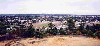
The Township of Esquimalt is a municipality at the southern tip of Vancouver Island, in British Columbia, Canada. It is bordered to the east by the provincial capital, Victoria, to the south by the Strait of Juan de Fuca, to the west by Esquimalt Harbour and Royal Roads, to the northwest by the New Songhees 1A Indian reserve and the town of View Royal, and to the north by a narrow inlet of water called the Gorge, across which is the district municipality of Saanich. It is almost tangential to Esquimalt 1 Indian Reserve near Admirals Road. It is one of the 13 municipalities of Greater Victoria and part of the Capital Regional District.

Greater Victoria is located in British Columbia, Canada, on the southern tip of Vancouver Island. It is usually defined as the thirteen municipalities of the Capital Regional District (CRD) on Vancouver Island as well as some adjacent areas and nearby islands.

Race Rocks Light is one of the first two lighthouses that were built on the west coast of Canada, financed by the British Government and illuminated in 1860. It is the only lighthouse on that coast built of rock, (granite) purportedly quarried in Scotland, and topped with sandstone quarried on Gabriola Island. The Islands of Race Rocks are located just off the southern tip of Vancouver Island, about 16 km (10 mi) southwest of Victoria, British Columbia.
Colwood is a city located on Vancouver Island to the southwest of Victoria, capital of British Columbia, Canada. Colwood was incorporated in 1985 and has a population of approximately 19,000 people. Colwood lies within the boundaries of the Greater Victoria area or Capital Regional District, in a region called the Western Communities, or the West Shore. It is one of the 13 component municipalities of Greater Victoria.

Admiral Sir Robert Lambert Baynes was a British Royal Navy admiral who as Commander-in-Chief, Pacific Station prevented the 1859 Pig War from escalating to a major conflict between the United States and the United Kingdom. Baynes joined the Royal Navy in 1810 and served in the Napoleonic Wars and the War of 1812. He took part in the Battle of Navarino in 1827 during the Greek War of Independence. He was promoted to captain in 1828 and commanded the vessels HMS Andromache and HMS Bellerophon and served as one of the senior officers in the Baltic Sea during the Crimean War. In 1857, he was made Commander-in-Chief, Pacific Station.
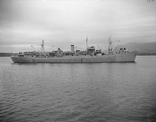
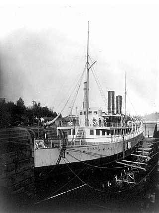
HMCS Cape Breton was a Royal Canadian Navy Cape-class maintenance ship. Originally built for the Royal Navy as HMS Flamborough Head in 1944, she was transferred in 1952. Upon her commissioning she was the second ship to bear the name Cape Breton. She served operationally from 1953–1964, when she was laid up. She was used as a floating machine shop until the late-1990s, before being sold for use as an artificial reef off the coast of British Columbia.
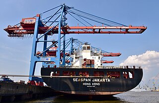
Seaspan ULC provides marine-related services to the Pacific Northwest. Within the Group are three (3) shipyards, an intermodal ferry and car float business, along with a tug and barge transportation company that serves both domestic and international markets. Seaspan, is part of the Washington Companies that are owned by Dennis Washington. Kyle Washington, is the Executive Chairman of Seaspan, who has become a Canadian citizen.
Háthayim Marine Provincial Park, formerly Von Donop Marine Provincial Park, is a provincial park in British Columbia, Canada, located on the north end of Cortes Island in the Discovery Islands.
Esquimalt Royal Naval Dockyard was a major British Royal Navy yard on Canada's Pacific coast from 1842 to 1905, subsequently operated by the Canadian government as HMC Dockyard Esquimalt, now part of CFB Esquimalt, to the present day.
Fairfield is a neighbourhood of Victoria, British Columbia. It is bounded by the James Bay, Downtown, Harris Green, Fernwood, Rockland, and Gonzales neighbourhoods, and meets the Strait of Juan de Fuca to the south.

Fort Rodd Hill National Historic Site is a 19th-century coastal artillery fort on the Colwood side of Esquimalt Harbour,. The site is adjacent to Fisgard Lighthouse National Historic Site, the first lighthouse on the west coast of Canada. Both the fort and lighthouse are managed and presented to the public by Parks Canada.

Fisgard Lighthouse National Historic Site, on Fisgard Island at the mouth of Esquimalt Harbour in Colwood, British Columbia, is the site of Fisgard Lighthouse, the first lighthouse on the west coast of Canada.

Burrard Dry Dock Ltd. was a Canadian shipbuilding company headquartered in North Vancouver, British Columbia. Together with neighbouring North Van Ship Repair and Yarrows Ltd. of Esquimalt, which were both later purchased by the company, Burrard built and refitted over 450 ships, including many warships for the Royal Navy and Royal Canadian Navy during the First and Second World Wars.

Victoria Harbour is a harbour, seaport, and seaplane airport in the Canadian city of Victoria, British Columbia. It serves as a cruise ship and ferry destination for tourists and visitors to the city and Vancouver Island. It is both a port of entry and an airport of entry for general aviation. Historically it was a shipbuilding and commercial fishing centre. While the Inner Harbour is fully within the City of Victoria, separating the city's downtown on its east side from the Victoria West neighbourhood, the Upper Harbour serves as the boundary between the City of Victoria and the district municipality of Esquimalt. The inner reaches are also bordered by the district of Saanich and the town of View Royal. Victoria is a federal "public harbour" as defined by Transport Canada. Several port facilities in the harbour are overseen and developed by the Greater Victoria Harbour Authority, however the harbour master's position is with Transport Canada.
Parker Island is a roughly 400-acre (160 ha) island in the Southern Gulf Islands of British Columbia, Canada. It forms the western side of Montague Harbour, sheltering it from the strong wind gusts of Trincomali Channel. The island may be reached by floatplane, private boat, helicopter or water taxi; there is no public ferry service.

HMS Alert was a 17-gun wooden screw sloop of the Cruizer class of the Royal Navy, launched in 1856 and broken up in 1894. She was the eleventh ship of the Royal Navy to bear the name, and was noted for her Arctic exploration work; in 1876 she reached a record latitude of 82° North. Alert briefly served with the US Navy, and ended her career with the Canadian Marine Service as a lighthouse tender and buoy ship.

Esquimalt Harbour is a natural harbour in Greater Victoria on the southern tip of Vancouver Island in British Columbia, Canada. The entrance to Esquimalt Harbour is from the south off the Strait of Juan de Fuca through a narrow channel known as Royal Roads. Esquimalt Harbour is situated west of Victoria Harbour, another major harbour in the region. Esquimalt Harbour is home to the Royal Canadian Navy's Maritime Forces Pacific, based at CFB Esquimalt.
Albert Head is a neighbourhood in Metchosin, British Columbia, Canada, part of the Western Communities area of Greater Victoria, British Columbia, Canada. It is located around and named after the headland of Albert Head, which is Department of National Defence property. Canadian Forces Base (CFB) Esquimalt operates CFB Albert Head which contains the British Columbia Canadian Ranger Company of the 4th Canadian Ranger Patrol Group, CFB Esquimalt Range Control, the Naval Tactical Operations Group (MTOG) and previously the Regional Cadet Support Unit (Pacific) which hosted Cadet summer training at the camp. Albert Head Lagoon derives its name from the headland that was named by the Royal Navy for Prince Albert.

HMCS Malahat is a Royal Canadian Navy Reserve Division (NRD) located in Victoria, British Columbia. Dubbed a stone frigate, HMCS Malahat is a land-based naval training establishment for part-time sailors as well as a local recruitment centre for the Canadian Naval Reserve. It is one of 24 naval reserve divisions in major cities across Canada.
Templar Channel is a channel in the Clayoquot Sound region of the west coast of Vancouver Island, British Columbia, Canada, lying between Lennard Island and Wickaninnish Island just northwest of the town of Tofino. An anchor was found in the channel that is possibly from the wreck of the Tonquin, an American trading ship that was destroyed in the area in 1811.
