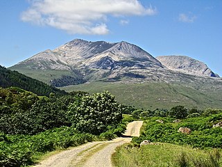
Beinn Eighe is a complex mountain massif in the Torridon area of Wester Ross in the Highlands of Scotland. Lying to the south of Loch Maree, it forms a long ridge with many spurs and summits, two of which are classified as Munros. The name Beinn Eighe comes from the Scottish Gaelic meaning file mountain. Unlike most other hills in the area it has a cap of Cambrian basal quartzite which gives the peaks of Beinn Eighe a distinctive light colour. Its complex topography has made it popular with both hillwalkers and climbers and the national nature reserve on its northern side makes it an accessible mountain for all visitors.
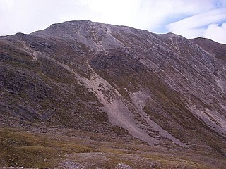
Beinn Liath Mhòr is a Scottish mountain situated in the mountainous area between Strath Carron and Glen Torridon in Wester Ross in the Highland region. Geologically Beinn Liath Mhòr is made up of Cambrian quartzite scree and Torridonian sandstones giving the mountain a distinctive colour contrast of light and dark. The mountain's other main characteristic is its two kilometre long undulating summit ridge which does not drop below 800 metres for its entire length. This culminates at the summit at its far western end at a height of 926 metres (3038 feet) making Beinn Liath Mhòr the 258th highest Munro.

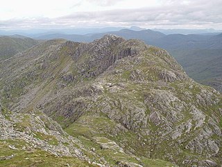
Sgorr Ruadh is a mountain situated in the mountainous area between Strath Carron and Glen Torridon in Wester Ross in the Highland Region of Scotland. It is located in Coire Lair near Achnashellach along with two other fine mountains, Beinn Liath Mhòr and Fuar Tholl, and is often climbed in conjunction with one or both of these other mountains.

Beinn Dorain, is a mountain in the Bridge of Orchy hills of Argyll and Bute, Scotland. It is the subject of Duncan Ban MacIntyre's best known Gaelic poem, Moladh Beinn Dòbhrainn ; MacIntyre had spent his youth and had worked as a gamekeeper in these parts.

Bynack More is a Scottish Mountain that is situated in the Cairngorms range, 16 kilometres east-south-east of the town of Aviemore in the Highland region.

Maol Cheann-dearg is a Scottish Mountain situated between Upper Loch Torridon and Loch Carron, in the Coulags deer forest in Wester Ross, Highland region. It is one of three Munros in this area and reaches a height of 933 metres (3,060 feet), it is slightly isolated from the other two being separated by a low col of 420 metres and therefore tends to be ascended separately. The mountain is typical of the region in that geologically it is made up of a mixture of sandstone and quartzite, it has a steep flanks and is rock-strewn. The dome shaped summit is littered with red sandstone boulders and lacking in vegetation making its translated name of “Bald Red Head” especially appropriate. The mountain is not to be confused with Maol Chinn-dearg, another Munro on the south Glen Shiel ridge.

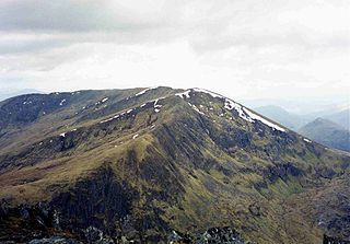
Binnein Beag is a Scottish mountain situated at the eastern end of the Mamores range seven kilometres north north-east of Kinlochleven. It is a relatively small, conical peak which is connected to its larger neighbour, Binnein Mòr, by a bealach at 750m. Despite being overshadowed by Binnein Mòr, it is listed as a Munro with a height of 943 m (3094 ft). It is commonly climbed from Kinlochleven in combination with Binnein Mòr. Its summit gives good views of Ben Alder to the east, the Grey Corries to the north, and the vast bulk of Binnein Mòr to the south-west.
An Riabhachan is a Scottish mountain in the Skye and Lochalsh district of the Highland council area. It is situated 35 kilometres east of Kyle of Lochalsh standing in an isolated position at the western end of Loch Mullardoch, ten kilometres from any public road.

Beinn Sgritheall is the highest mountain in the Glenelg area of the Highlands of Scotland. The main approach is via Arnisdale on the shores of Loch Hourn or via Gleann Beag to the north, with its well-known brochs. The view from the summit was described by Sir Hugh Munro, a founder member of the Scottish Mountaineering Club, as "perhaps the most beautiful I have seen in Scotland".
Sgòr Gaoith is a mountain in the western massif of the Cairngorms, and is separated from the Braeriach massif by the broad valley of Glen Einich. The second-highest summit of the mountain is Sgoran Dubh Mòr, which lies 1.3 km away due NNE along the summit ridge. The eastern side of Sgòr Gaoith is girded by steep cliffs which plunge down to Loch Einich; the western side is composed of heather slopes and a number of shallow corries.

An Ruadh-stac is a Scottish mountain situated in the Wester Ross region of the Highland council area. It is located 26 km north east of Kyle of Lochalsh.

A' Ghlas-bhienn is a mountain in the Northwest Highlands of Scotland. It lies in the Kintail area of Ross-shire, close to the settlement of Morvich.

An Stac is a mountain in the Northwest Highlands, Scotland, on the shore of Loch Ailort on the west coast of Lochaber.

Am Faochagach is a mountain in the Northwest Highlands of Scotland. It is located in Wester Ross, north of the main road to Ullapool.

Beinn Ruadh is a mountain of Argyll and Bute in Scotland. Part of the Grampian Mountains, it lies between Loch Eck and Loch Long in Argyll Forest Park.

Ruadh Stac Mor is a mountain in the Northwest Highlands of Scotland. It is located in the Dundonnell and Fisherfield Forest in Wester Ross.
Garbh Chioch Mhor is a mountain in the Northwest Highlands of Scotland. It lies in the Lochaber region, between Loch Nevis and Loch Quoich.

Sgurr a' Gharaidh is a mountain in the Northwest Highlands of Scotland. It lies in Wester Ross, north of Loch Carron.

Aonach Beag is a 1,116-metre (3,661 ft) mountain in the Highlands of Scotland in the remote area between Loch Ericht and Loch Laggan located about 4 kilometres (2.5 mi) northwest of Ben Alder. Its prominence is 99 metres (325 ft) with its parent peak, Geal-Charn, about 1 kilometre (0.62 mi) to the east. In Gaelic, Aonach Beag means "little ridge" despite it being a Munro. It should not be confused with the better-known Munro near Ben Nevis, also called Aonach Beag, about 30 kilometres (19 mi) to the west.

Tom a' Chòinich is a 1,112-metre (3,648 ft) mountain in Glen Affric in the Scottish Highlands. It is a Munro and less than 1 kilometre to the west is the 1,032-metre (3,386 ft) Munro Top Tom a' Chòinich Beag. In Gaelic, Tom a' Chòinich means "mossy hillock". Its prominence is 149 metres (489 ft) with its parent peak, Càrn Eige, about 4 kilometres (2.5 mi) to the west. This mountain should not be confused with the 955-metre (3,133 ft) Munro Top also called Tom a' Chòinnich near Ben Wyvis but which is usually spelled slightly differently.
