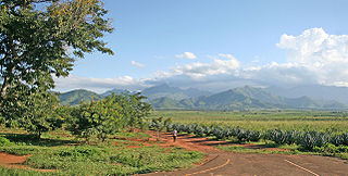
Morogoro Region is one of Tanzania's 31 administrative regions. The regional capital is the municipality of Morogoro. According to the 2012 national census, the region had a population of 2,218,492, which was higher than the pre-census projection of 2,209,072. For 2002-2012, the region's 2.4 percent average annual population growth rate was tied for the fourteenth highest in the country. It was also the 22nd most densely populated region with 31 people per square kilometer.

Biharamulo District is one of the eight districts of the Kagera Region of Tanzania. It is bordered to the north by Karagwe District and Muleba District, to the east and south by Geita Region, to the west by Ngara District, and to the southwest by the Kigoma Region. Its administrative seat is Biharamulo town. Biharamulo Game Reserve is located within the borders of the district.
Kilosa District is one of the six districts of the Morogoro Region of Tanzania. Its administrative seat is the town of Kilosa. Kilosa District covers 14,918 square kilometres (5,760 sq mi). It is bordered to the north by the Manyara Region, to the northeast by the Tanga Region, to the east by Mvomero District, to the southeast by Morogoro Rural District, to the south by Kilombero District, to the southwest by the Iringa Region and to the west by the Dodoma Region.

Mvomero is one of the six districts of the Morogoro Region of Tanzania. It is bordered to the north by the Tanga Region, to the northeast by the Pwani Region, to the east and southeast by Morogoro Rural District and Morogoro Urban District and to the west by Kilosa District.

Morogoro Rural District is one of the six districts of the Morogoro Region of Tanzania. Morogoro Rural District covers 19,056 square kilometres (7,358 sq mi). It is bordered to the north and east by the Pwani Region, to the south by Kilombero District, to the southwest by the Kilosa District and to the west by the Mvomero District and the Morogoro Urban District.

Kongwa District is one of the seven districts of the Dodoma Region of Tanzania. It is bordered to the north by Manyara Region, to the east by Morogoro Region, to the south by Mpwapwa District, and to the west by Chamwino District. Its district capital is the town of Kongwa.
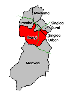
Ikungi District is one of the six districts of the Singida Region of Tanzania. It is one of the 20 new districts that were formed in Tanzania since 2010; it was split off from Singida Rural District. Ikungi District is bordered to the north by Iramba District, Singida Urban District and Singida Rural District, to the east by Manyara Region, to the south by Manyoni District and to the west by Tabora Region. Its administrative seat is the town of Ikungi.
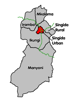
Singida Urban District is one of the six districts of the Singida Region of Tanzania. It is bordered to the south and west by the Ikungi District and to the north and east by the Singida Rural District. Its administrative seat is the town of Singida.

Manyoni District is one of the six districts in the Singida Region of Tanzania. The district capital is the town of Manyoni. The district is bordered to the north by the Ikungi District, to the east by the Dodoma Region, to the south by the Iringa Region, to the southwest by the Mbeya Region and to the west by the Tabora Region.
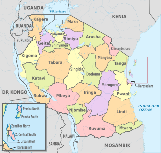
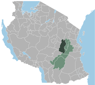
The administrative divisions of Tanzania are controlled by Part I, Article 2.2 of the Constitution of Tanzania. Tanzania is divided into thirty-one regions. Each region is subdivided into districts. The districts are sub-divided into divisions and further into local wards. Wards are further subdivided for management purposes: for urban wards into streets and for rural wards into villages. The villages may be further subdivided into hamlets.

Kilosa (Kilossa) is a city in the Morogoro Region of Tanzania, East Africa. It is the administrative seat for Kilosa District. As of 2002, the population of the town was 26,060.
Ulanga District is one of the six districts of the Morogoro Region of Tanzania. the administrative seat is in Mahenge. It covers 24,460 square kilometres (9,444 sq mi) of which 4,927 square kilometres (1,902 sq mi) is in forest reserves. Ulanga District is bordered to the north and west by the Kilombero District, to the east by the Lindi Region and to the south by the Ruvuma Region.
Mandege is an administrative ward in Gairo District in the Morogoro Region of Tanzania, East Africa. As of 2002, the population of the ward was 7,247. The Mandege Forest Station, headquarters for the Mamiwa Forest Reserve, is located there.
Chagongwe is a town and administrative ward in Gairo District in the Morogoro Region of Tanzania, East Africa. As of 2002, the population of the ward was 7,337. There is a government-run dispensary and a primary school there. The only access to the town is over a single lane, unimproved road.
Gairo District is one of the seven districts of the Morogoro Region of Tanzania, East Africa. It is located in the northwest corner of Morogoro Region. The administrative seat is in the town of Gairo.
Gairo is a large town and an administrative ward in Gairo District in the Morogoro Region of Tanzania, East Africa. The town is the administrative centre for Gairo District. It is located on the main Dodoma to Dar es Salaam road and is a transshipment point, as well as a shipping point for the agricultural products of the district. As of 2002, the town's population was 16,982,

Morogoro Urban District is one of the six districts of the Morogoro Region of Tanzania. It contains the city Morogoro, capital of the Morogoro Region, and no villages. Morogoro Urban District covers 260 square kilometres (100 sq mi). It is bordered to the east and south by the Morogoro Rural District and to the north and west by Mvomero District
Kimamba 'A' is an administrative ward in the Kilosa district in the Morogoro Region of Tanzania. The ward was created by 1988, and had a population of 5,663 in 2002.
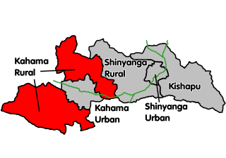
Kahama Rural District is one of the five districts of the Shinyanga Region of Tanzania. Its administrative centre is the town of Kahama. The district consists of two separate parts, divided by Kahama Urban District. The area to the northeast is Msalala Council, while the part to the southwest is Ushetu Council.
