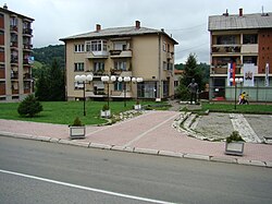
Rudnik (Gornji Milanovac)

Last updated
Rudnik
Рудник
Village
Varos Rudnik1.jpg
GrbVarosiceRudnik.jpg
Serbia adm location map.svg
Red pog.svg
Rudnik
Coordinates: 44°08′27″N20°29′56″E / 44.14083°N 20.49889°E / 44.14083; 20.49889
CountryFlag of Serbia.svg  Serbia
District Moravica District
Municipality Gornji Milanovac
Area
  Total23.38 km2 (9.03 sq mi)
Elevation
595 m (1,952 ft)
Population
 (2011)
  Total1,490
  Density64/km2 (170/sq mi)
Time zone UTC+1 (CET)
  Summer (DST) UTC+2 (CEST)

Rudnik is a village in the municipality of Gornji Milanovac, Serbia. According to the 2011 census, the town has a population of 1,490 people. [1]

History

In 1363 it was under the control of Nikola Altmanović. It probably fell under the control of his uncle Vojislav Vojinović some years earlier and had been granted to Nikola as a vassal. [2]

Mineral resources in this area attracted the attention of the Old Romans, who conquered this region later since they needed the ore to forge coins and arms. After a long period of battles with the Celts and the remaining Illyrians, the area was integrated into the Roman provinces. Right next to the mine shafts on the south-western side of Mt. Rudnik, a stone plate was found with the inscription: TERRA MATER TEA – “The Mother Earth Goddess”. This temple served to the miners who prayed there for rescue in case of emergency before entering the shaft. The temple was destroyed at one point in time, to be reconstructed by the Emperor Septimius Severus, who placed the above- mentioned stone plate at its entrance. One millennium later first documents mentioning Rudnik can be found. Since 1300 silver coins in medieval Serbia are made at Rudnik under the rule od king Dragutin. It was a prosperous time for Rudnik. This importance of Rudnik last for more than 150 years, until 1458. Coins had 2.4 grs and they were more valuable than other coins made in Serbia. Apart from Silver, Lead and Copper were also extracted. [3] [4]

Related Research Articles

<span class="mw-page-title-main">Gornji Milanovac</span> Town and municipality in Šumadija and Western Serbia, Serbia

Gornji Milanovac is a town and municipality located in the Moravica District of central Serbia. The population of the town is 24,216, while the population of the municipality is 44,406.

<span class="mw-page-title-main">Takovo</span> Place in Moravica District, Serbia

Takovo is a village in the municipality of Gornji Milanovac, Serbia. According to the 2011 census, the village has a population of 458 people.

<span class="mw-page-title-main">Rudnik (mountain)</span>

Rudnik is a mountain in central Serbia, near the town of Gornji Milanovac. Its highest peak Cvijićev vrh, named after geologist and biologist Jovan Cvijić, has an elevation of 1,132 meters above sea level. It has several other peaks over 1000 m: Srednji Šturac, Mali Šturac, Molitve, Paljevine and Marijanac. Rudnik literally means 'mine' in Serbian, apparently referring to the mountain's rich mineral resources. The name is probably a testament to the mining activity associated with the mountain throughout several millennia.

Donji Branetići is a village in the municipality of Gornji Milanovac, Serbia. According to the 2002 census, the village has a population of 134 people.

<span class="mw-page-title-main">Drenova (Gornji Milanovac)</span> Village in Moravica District, Serbia

Drenova is a village in the municipality of Gornji Milanovac, Serbia. According to the 2002 census, the village has a population of 264 people.

Gornji Banjani is a village in the municipality of Gornji Milanovac, Serbia. According to the 2002 census, the village has a population of 227 people.

Gornji Branetići is a village in the municipality of Gornji Milanovac, Serbia. According to the 2002 census, the village has a population of 578 people.

<span class="mw-page-title-main">Kamenica (Gornji Milanovac)</span> Village in Moravica District, Serbia

Kamenica is a village in the municipality of Gornji Milanovac, Serbia. According to the 2002 census, the village has a population of 37 people.

Leušići is a village in the municipality of Gornji Milanovac, Serbia. According to the 2002 census, the village has a population of 162 people.

Lunjevica is a village in the municipality of Gornji Milanovac, Serbia. According to the 2002 census, the village has a population of 512 people. Revolutionary Nikola Lunjevica was born in the village.

Majdan is a village in the municipality of Gornji Milanovac, Serbia. According to the 2002 census, the village has a population of 513 people.

Prnjavor is a village in the municipality of Gornji Milanovac, Serbia. According to the 2002 census, the village has a population of 107 people.

Nevade is a village in the municipality of Gornji Milanovac, Serbia. At the 2011 census, the village had a population of 627 people.

Ručići is a village in the municipality of Gornji Milanovac, Serbia. According to the 2002 census, the village has a population of 144 people.

Semedraž is a village in the municipality of Gornji Milanovac, Serbia. According to the 2002 census, the village has a population of 264 people.

Sinoševići is a village in the municipality of Gornji Milanovac, Serbia. According to the 2002 census, the village has a population of 200 people.

Teočin is a village in the municipality of Gornji Milanovac, Serbia. At the 2002 census, the village had a population of 690 people.

Ugrinovci is a village in the municipality of Gornji Milanovac, Serbia. According to the 2002 census, the village has a population of 480 people.

<span class="mw-page-title-main">Dobrica Erić</span> Serbian writer and poet (1936–2019)

Dobrica Erić was a Serbian writer and poet.

<span class="mw-page-title-main">Takovo Meeting</span>

The Takovo Meeting was the gathering of Serbian leaders held on 23 April [O.S. 11 April] 1815 at Takovo, a village near present-day Gornji Milanovac. Two years following the collapse of the First Serbian Uprising, the decision was made to start a new uprising against the Ottoman Empire under the leadership of Miloš Obrenović. The meeting was held on the day of the traditional people's gathering, to which people from many Serbian regions attended. Preparations were kept in strict secrecy, with agitation limited to territories of Rudnik, Kragujevac and Čačak nahias. The idea of a new uprising was met with broad support among the masses.

References

  1. Popis stanovništva, domaćinstava i Stanova 2002. Knjiga 1: Nacionalna ili etnička pripadnost po naseljima. Republika Srbija, Republički zavod za statistiku Beograd 2003. ISBN   86-84433-00-9
  2. R. Mihaljčić, Kraj Srpskog Carstva, SKZ, Beograd. 1975. pp. 36.
  3. RUDNIK I VENČAC  Sa okolinom u srednjem veku i ranoj moderni  Tematski zbornik radova sa naučnog skupa održanog 21. oktobra 2017. godine u Narodnom muzeju u Aranđelovcu  Urednici: Siniša Mišić, Dejan Radičević, Marko Šuica  (Narodni muzej Aranđelovac – Aranđelovac / Centar za istorijsku geografiju i istorijsku demografiju, Filozofski fakultet – Beograd, Aranđelovac, 2018, broš, 326)
  4. http://www.contangorudnik.co.rs [ bare URL ]

Coordinates: 44°08′27″N20°29′56″E / 44.14083°N 20.49889°E / 44.14083; 20.49889