
The Remarkables are a mountain range and skifield in Otago in the South Island of New Zealand. Located on the southeastern shore of Lake Wakatipu, the range lives up to its name by rising sharply to create a remarkable backdrop for the waters. The range is clearly visible from the nearby town of Queenstown.
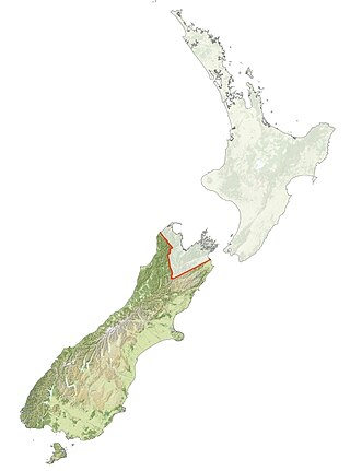
Ngāi Tahu, or Kāi Tahu, is the principal Māori iwi (tribe) of the South Island. Its takiwā is the largest in New Zealand, and extends from the White Bluffs / Te Parinui o Whiti, Mount Mahanga and Kahurangi Point in the north to Stewart Island / Rakiura in the south. The takiwā comprises 18 rūnanga corresponding to traditional settlements. According to the 2018 census an estimated 74,082 people affiliated with the Kāi Tahu iwi.

The Mataura River is in the Southland Region of the South Island of New Zealand. It is 240 kilometres (150 mi) long.

Runanga is a small town on the West Coast of the South Island of New Zealand. It is located eight kilometres to the northeast of Greymouth, to the north of the Grey River. Barrytown is 21 kilometres (13 mi) further north. State Highway 6 and the Rapahoe Branch railway run through the town. Runanga was formerly a railway junction, with the steep Rewanui Branch diverging from the Rapahoe line until closure in 1985.
The Cardrona River is in Otago in the South Island of New Zealand. It is one of the first tributaries of the Clutha River / Mata-Au, which it meets only 5 kilometres (3 mi) from the latter's origin at the outflow of Lake Wānaka.

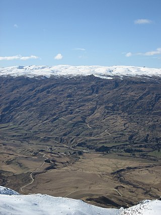
Lake Hayes is a small lake in the Wakatipu Basin in Central Otago, in New Zealand's South Island. It is located close to the towns of Arrowtown and Queenstown.

Ngāti Awa is a Māori iwi (tribe) centred in the eastern Bay of Plenty Region of New Zealand. It is made of 22 hapū (subtribes), with 15,258 people claiming affiliation to the iwi in 2006. The Ngāti Awa people are primarily located in towns on the Rangitaiki Plain, including Whakatāne, Kawerau, Edgecumbe, Te Teko and Matatā. Two urban hapū also exist in Auckland and Wellington.
David Closs McKenzie is a former long-distance runner from New Zealand. McKenzie won the Boston Marathon in 1967, setting a new course record of 2 hours 15 minutes 45 seconds. He was the first New Zealander to win the Boston Marathon.
Oingo Lake is one of several small lakes located northwest to the city of Hastings in the Hawke's Bay Region of the eastern North Island of New Zealand.

Lake Forsyth is a lake on the south-western side of Banks Peninsula in the Canterbury region of New Zealand, near the eastern end of the much larger Lake Ellesmere / Te Waihora. State Highway 75 to Akaroa and the Little River Rail Trail run along the north-western side of the lake.
Ngāti Tahu – Ngāti Whaoa is a Māori iwi of New Zealand whose traditional territory lies between the Rotorua lakes and Lake Taupō, and is centred on Orakei Korako, on the Waikato River.

Moses Ayrton was a New Zealand Methodist minister and socialist.
In Tikanga Māori, a rūnanga is a tribal council, assembly, board or boardroom. The term can also be a verb meaning "to discuss in an assembly". An iwi (tribe) can have one governing rūnanga and many sub rūnanga, in such cases it can be used to mean the subdivision of a tribe governed by that council. It is also used for non tribal affiliations as with the CTU Runanga a sub union for Māori workers.

Southland is New Zealand's southernmost region. It consists of the southwestern portion of the South Island and includes Stewart Island. Southland is bordered by the culturally similar Otago Region to the north and east, and the West Coast Region in the extreme northwest. The region covers over 3.1 million hectares and spans 3,613 km of coastline. As of June 2023, Southland has a population of 103,900, making it the eleventh-most-populous New Zealand region, and the second-most sparsely populated. Approximately half of the region's population lives in Invercargill, Southland's only city.
Te Taoū is a Māori iwi (tribe) of Northland and the Auckland Region in New Zealand. Together with Te Uri-o-Hau, Te Roroa and Ngāti Whātua-o-Ōrākei, it comprises the iwi (tribe) of Ngāti Whātua. The four iwi can act together or separately as independent tribes. Te Taoū has been considered to be a hapū (subtribe) of Ngāti Whātua in the past, but this is disputed. Te Taoū have attempted to separate from Ngāti Whātua in Treaty of Waitangi settlement negotiations, claiming that Ngāti Whātua do not represent them and being kept under Ngāti Whātua will cause a loss of sovereignty and mana.
Rākaihautū was the captain of the Uruaokapuarangi canoe and a Polynesian ancestor of various iwi, most famously of Waitaha and other southern groups, though he is also known in the traditions of Taitokerau, and in those of Rarotonga.

The Runanga Miners' Hall is a hall in the town of Runanga, on the West Coast of New Zealand's South Island. The current structure dates from 1937, and replaced an early miners' hall from 1908 that was destroyed by fire. The hall is notable for its place in the history of the organised labour movement in New Zealand, and was granted historic place category 1 status by Heritage New Zealand in 2013.

Browning Pass / Nōti Raureka is a mountain pass across the Southern Alps, on the South Island of New Zealand. The pass reaches an elevation of 1,411 metres (4,629 ft) above sea level, connecting the upper reaches of the Wilberforce River with the West Coast.

Coopers Lagoon / Muriwai is a small coastal waituna-type lagoon in the Canterbury region of New Zealand, located approximately halfway between the mouth of the Rakaia River and the outlet of the much larger Lake Ellesmere / Te Waihora. While the present-day lagoon is separated from the nearby Canterbury Bight by approximately 100 metres (330 ft), the water of the lagoon is considered brackish and early survey maps show that, until recently, the lagoon was connected to the ocean by a small channel. The lagoon, along with the surrounding wetlands, has historically been an important mahinga kai for local Māori.
