
According to the International Civil Aviation Organization (ICAO), a runway is a "defined rectangular area on a land aerodrome prepared for the landing and takeoff of aircraft". Runways may be a human-made surface or a natural surface. Runways, taxiways and ramps, are sometimes referred to as "tarmac", though very few runways are built using tarmac. Takeoff and landing areas defined on the surface of water for seaplanes are generally referred to as waterways. Runway lengths are now commonly given in meters worldwide, except in North America where feet are commonly used.

In aviation, the instrument landing system (ILS) is a precision radio navigation system that provides short-range guidance to aircraft to allow them to approach a runway at night or in bad weather. In its original form, it allows an aircraft to approach until it is 200 feet (61 m) over the ground, within a 1⁄2 mile (800 m) of the runway. At that point the runway should be visible to the pilot; if it is not, they perform a missed approach. Bringing the aircraft this close to the runway dramatically increases the range of weather conditions in which a safe landing can be made. Other versions of the system, or "categories", have further reduced the minimum altitudes, runway visual ranges (RVRs), and transmitter and monitoring configurations designed depending on the normal expected weather patterns and airport safety requirements.

A taxiway is a path for aircraft at an airport connecting runways with aprons, hangars, terminals and other facilities. They mostly have a hard surface such as asphalt or concrete, although smaller general aviation airports sometimes use gravel or grass.

Teterboro Airport is a general aviation relief airport situated in the boroughs of Teterboro, Moonachie, and Hasbrouck Heights in Bergen County, New Jersey. It is owned and managed by the Port Authority of New York and New Jersey, and operated by AFCO AvPORTS Management. The airport is in the New Jersey Meadowlands, 12 miles (19 km) north-northwest of Midtown Manhattan, making it popular for private and corporate aircraft. The airport has a weight limit of 100,000 pounds (45,000 kg) on aircraft, making it nonviable for any commercial service.

A navigation light, also known as a running or position light, is a source of illumination on a watercraft, aircraft or spacecraft, meant to give information on the craft's position, heading, or status. Some navigation lights are colour-coded red and green to aid traffic control by identifying the craft's orientation. Their placement is mandated by international conventions or civil authorities such as the International Maritime Organization (IMO).
The visual approach slope indicator (VASI) is a system of lights on the side of an airport runway threshold that provides visual descent guidance information during final approach. These lights may be visible from up to 8 kilometres (5.0 mi) during the day and up to 32 kilometres (20 mi) or more at night.

A precision approach path indicator (PAPI) is a system of lights on the side of an airport runway threshold that provides visual descent guidance information during final approach. It is generally located on the left-hand side of the runway approximately 300 metres (980 ft) beyond the landing threshold of the runway.
Pilot-controlled lighting (PCL), also known as aircraft radio control of aerodrome lighting (ARCAL) or pilot-activated lighting (PAL), is a system that allows aircraft pilots to control the lighting of an airport or airfield's approach lights, runway edge lights, and taxiways via radio.

Morristown Airport is in Morris County, New Jersey, United States, three miles east of downtown Morristown and 40 miles west of Manhattan, New York City. Operated by DM AIRPORTS, LTD, it is in the Whippany section of Hanover. The National Plan of Integrated Airport Systems for 2011–2015 called it a general aviation reliever airport.

In aviation, the runway visual range (RVR) is the distance over which a pilot of an aircraft on the centreline of the runway can see the runway surface markings delineating the runway or the lights delineating the runway or identifying its centre line. RVR is normally expressed in meters or feet. RVR is used to determine the landing and takeoff conditions for aircraft pilots, as well as the type of operational visual aids used at the airport.
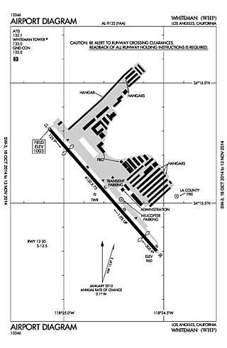
Whiteman Airport is a general aviation airport in the northeastern San Fernando Valley community of Pacoima, in the city of Los Angeles, California, United States.
Red Deer Regional Airport is located 6 nautical miles south southwest of Red Deer, Alberta, Canada. The airport serves Charter and General Aviation.
Tri-Cities Airport is a village-owned, public-use airport located three nautical miles (6 km) southwest of the central business district of Endicott, a village in Broome County, New York, United States. According to the FAA's National Plan of Integrated Airport Systems for 2009–2013, it is classified as a general aviation airport.
Safford Regional Airport is in Safford, Graham County, Arizona, United States, 3 miles east of downtown Safford; the airport is owned by the Safford municipal government. The FAA's National Plan of Integrated Airport Systems for 2009–2013 categorizes it as a general aviation facility. It is the only paved airport in Graham County.

An approach lighting system (ALS) is a lighting system installed on the approach end of an airport runway and consisting of a series of lightbars, strobe lights, or a combination of the two that extends outward from the runway end. ALS usually serves a runway that has an instrument approach procedure (IAP) associated with it and allows the pilot to visually identify the runway environment and align the aircraft with the runway upon arriving at a prescribed point on an approach.

Aviation obstruction lighting is used to enhance the visibility of structures or fixed obstacles which may conflict with the safe navigation of aircraft. Obstruction lighting is commonly installed on towers, buildings, and even fences located in areas where aircraft may be operating at low altitudes. In certain areas, some aviation regulators mandate the installation, operation, color, and/or status notification of obstruction lighting. For maximum visibility and collision-avoidance, these lighting systems commonly employ one or more high-intensity strobe or LED devices which can be seen by pilots from many miles away from the obstruction.

Paraburdoo Airport is an airport serving Paraburdoo, a town in the Pilbara region of Western Australia. The airport is located 5 nautical miles northeast of Paraburdoo. It also serves the town of Tom Price, with bus services completing the extra 71 km to Tom Price.

The Spartanburg Downtown Memorial Airport is a general aviation airport located in the city of Spartanburg, South Carolina. The airport is 3 miles (4.8 km) from downtown Spartanburg, which makes it popular for private and corporate aircraft.
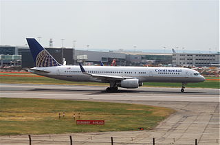
Continental Airlines Flight 1883 was a Boeing 757 that mistakenly landed on a taxiway at Newark Liberty International Airport on the evening of October 28, 2006. There were no reported injuries or damage, but the narrowly averted disaster was investigated by the National Transportation Safety Board, and caused the Federal Aviation Administration to reevaluate and modify air and ground safety procedures at and around Newark Airport.

Aztec Municipal Airport is a public-use airport located two nautical miles northwest of the central business district of Aztec, in San Juan County, New Mexico, United States. It is a general aviation airport with no tower, fixed base operator (FBO), or commercial services, but which is popular among smaller light sport and general aviation aircraft doing cross country flights, where the airport serves as a GA-friendly waypoint, refueling stop, and overnight layover stop.
