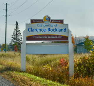
Clarence-Rockland is a city in Eastern Ontario, Canada, in the United Counties of Prescott and Russell on the Ottawa River. Clarence-Rockland is located immediately to the east of Ottawa and is considered part of the Prescott and Russell County. The city was formed on January 1, 1998, through the amalgamation of the Town of Rockland with Clarence Township. Despite its recent formation, a community has been established in the region since the early 1840s.

The United Counties of Prescott and Russell is a county located in the Canadian province of Ontario. Its county seat is L'Orignal. The county was created as a result of a merger between Russell County and Prescott County in 1820. It is located in Eastern Ontario, in the wedge-shaped area between the Ottawa River and St. Lawrence River, approximately 55 kilometres (34 mi) east of the City of Ottawa. Under Ontario law, the county is an Upper-tier Municipality.
The Canadian province of Ontario has several historic counties, which are past census divisions that no longer exist today. Most historic counties either merged with other counties, or became regional municipalities or single-tier municipalities. Although counties had existed prior to 1849, after 1849 they replaced the district systems in administering local government and courts in Ontario.
Russell Road is an arterial road in Eastern Ontario, Canada. It begins in Ottawa in the Riverview neighbourhood and runs eastward through the rural communities of Ramsayville, Carlsbad Springs and Bearbrook in Ottawa and through the Municipality of Clarence-Rockland, connecting the communities of Cheney and Bourget, ending at Boundary Road on the eastern border of Clarence Rockland. In Ottawa it is officially Ottawa Road #26, and in Clarence-Rockland as United Counties of Prescott and Russell County Road #2.

Orléans is a federal electoral district in Ottawa, Ontario, Canada, that has been represented in the House of Commons of Canada since 1988.

Carleton County is the name of a former county in Ontario, Canada. In 1969, it was superseded by the Regional Municipality of Ottawa–Carleton. In 2001, the Regional Municipality and its eleven local municipalities were replaced by the current city of Ottawa.

The Regional Municipality of Ottawa–Carleton was a Regional Municipality and Census Division in Ontario, Canada, that existed between January 1, 1969, and January 1, 2001, and was primarily centred on the City of Ottawa. It was created in 1969 by restructuring Carleton County and annexing Cumberland Township from the United Counties of Prescott and Russell into the newly created Region of Ottawa–Carleton.

Bourget is an unincorporated village in Eastern Ontario, Canada, near the Cobbs Lake Creek, in the city of Clarence-Rockland in the United Counties of Prescott and Russell.

Glengarry—Prescott—Russell is a federal electoral district in Ontario, Canada, that has been represented in the House of Commons of Canada since 1953.
March Township is a geographic township and former municipality originally part of Carleton County in eastern Ontario, Canada. It is currently part of the City of Ottawa. It is located in the western part of the county, bordered to the northwest by Torbolton Township, to the southwest by Huntley Township, to the east by Nepean, to the south by Goulbourn Township and to the north by the Ottawa River. According to the Canada 2001 Census, the Township had a population of approximately 26,650.

Metcalfe is a population centre located in Osgoode Ward, in the rural south-end of the city of Ottawa, Ontario, Canada. Prior to amalgamation in 2001, the community was in Osgoode Township. According to the Canada 2016 Census, it has a population of 1,776.

North Gower is a small village in eastern Ontario, originally part of North Gower Township, now part of the city of Ottawa. Surrounding communities include Richmond, Kemptville, Kars and Manotick. Public high school students in this area go to South Carleton High School in Richmond. Elementary school students go to Marlborough Public School in North Gower.

The Township of Russell is a municipal township, located south-east of Canada's capital of Ottawa in eastern Ontario, in the United Counties of Prescott and Russell, on the Castor River.
Kars is a village on the Rideau River within Rideau-Jock Ward in the city of Ottawa, Ontario. Prior to joining the city in 2000 it was part of Rideau Township.
Cambridge Township was a township in Ontario, Canada. Along with Clarence Township, Russell Township and Cumberland Township, Cambridge Township was one of the four townships of Russell County.

Ottawa Road 174, formerly Ottawa-Carleton Regional Road 174 and commonly referred to as Highway 174, is a city-maintained road in the City of Ottawa which serves the eastern suburbs of Orléans and Cumberland. The four-lane freeway segment between Highway 417/Aviation Parkway junction to Trim Road is also known as the Queensway, in addition the Queensway name continues to be applied to Highway 417 west of that intersection. Although the road continues through the towns of Rockland and Hawkesbury to the Quebec border, the portion east of the Ottawa city boundary is known as Prescott and Russell County Road 17.
Glengarry—Prescott—Russell is a provincial electoral district in eastern Ontario, Canada. It elects one member to the Legislative Assembly of Ontario.
Orléans is a provincial electoral district in eastern Ontario, Canada. It elects one member to the Legislative Assembly of Ontario. Before the 2018 election, it was known as Ottawa—Orléans.

The National Capital Junior Hockey League (NCJHL) is a Junior ice hockey league in Ontario, Canada, sanctioned by the Hockey Eastern Ontario and Hockey Canada. The league is meant to be an interprovincial league between Ontario and Quebec.

This is the outline of the geography of the city of Ottawa, the capital of Canada. Ottawa's current borders were formed in 2001, when the former city of Ottawa amalgamated with the ten other municipalities within the former Regional Municipality of Ottawa–Carleton. Ottawa is now a single-tiered census division, home to 1,017,449 people.