Chief Dawid Stuurman International Airport is an airport serving Port Elizabeth (Gqeberha), a city in the Eastern Cape province in South Africa. It was formerly known as H. F. Verwoerd Airport and Port Elizabeth International Airport. The airport is owned and operated by the Airports Company South Africa which also operates nine other airports around South Africa. The airport is located approximately two miles south of the city's central business district. In 2017, the airport served 1,620,705 passengers.

Pilanesberg International Airport is an airport serving Sun City in the North West province of South Africa. It is located adjacent to the Pilanesberg National Park.
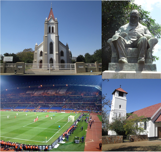
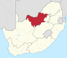
Rustenburg is a city at the foot of the Magaliesberg mountain range. Rustenburg is the most populous city in North West province, South Africa. In 2017, the city's Gross Domestic Product (GDP) reached ZAR 63.8 billion, accounting for 21.1% of the GDP of the North West Province, and 1.28% of the GDP of South Africa. Rustenburg was one of the official host cities of the 2010 FIFA World Cup, being in close proximity to Phokeng, the capital of the Royal Bafokeng Nation, where the Royal Bafokeng Stadium is located. The England national football team also used this as their base camp for the tournament.

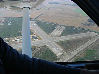
Faisalabad International Airport is an international airport and standby Pakistan Air Force military base situated on Jhang Road, 10 kilometres (6.2 mi) southwest of the city centre of Faisalabad, in the Punjab province of Pakistan. The airport is home to two flying schools who use the airfield for regular training for new cadets and aviation enthusiasts.
A flight information service (FIS) is a form of air traffic service which is available to any aircraft within a flight information region (FIR), as agreed internationally by ICAO.
Taupo Airport is a small airport 8 km (5.0 mi) to the south of Taupō township on the eastern shores of Lake Taupō, New Zealand.
Goulburn Airport is a general aviation airport located 7 km (4.3 mi) south of Goulburn, New South Wales. Throughout the 1990s, suggestions were put forward to have Goulburn airport as a secondary international airport to service Sydney.

Denham Aerodrome is an operational general aviation aerodrome located 1.5 NM east of Gerrards Cross, near Denham, Buckinghamshire, England. It lies beneath London's Class D airspace. VFR entry/exit points are at Maple Cross (CHT) and St Giles Church. Entry lanes and circuit height are at 1,000 ft (300 m) MSL. It has one paved runway, aligned 06/24, a grass runway also aligned 06/24 which is referred to as the northside grass and one grass runway aligned 12/30. It also has substantial hangarage.
Mahikeng Airport or Mmabatho Airport is an airport serving Mahikeng and Mmabatho, the current and former capital cities of the North West province in South Africa. The airport is widely known as Mafikeng Airport after Mahikeng's former name. The airport is managed by the North West Province Department of Transport and Roads. The airport is a former air force base of the Boputhatswana Defence Force and was previously classified as an international airport. As of 2014, discussions and construction was in progress in order for the airport to regain its status as an international airport.
Arua Airport is a civilian airport serving the city of Arua in the Northern Region of Uganda. As of November 2016, it is one of the 47 airports in the country.

The Parachute Association of South Africa (PASA) manages the sports of parachuting and skydiving in South Africa on behalf of the South African Civil Aviation Authority.

General aviation in the United Kingdom encompasses a variety of commercial and non-commercial aviation activities.
Kasese Airport is an airport in Uganda.
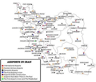
The Civil Aviation Authority of Islamic Republic of Iran (CAA.IRI), is Iran's civil aviation agency. It is the statutory corporation which oversees and regulates all aspects of civil aviation in Iran. The organization was established in July 1946 and its headquartered at Mehrabad International Airport in Tehran. It investigates aviation accidents and incidents in Iran.
The Western Province Sport Parachute Club (WPSPC) provides a facility for sports skydiving and student training and is operated and managed on a volunteer basis by a committee elected by its members. The club is a not-for-gain body corporate under common law.
Robertson Airfield, licensed according to South African Civil Aviation Authority standards, is an unmanned municipal airport situated 1 km to the east of the Western Cape town of Robertson in South Africa.
Cape Winelands Airport is an ex-South African Air Force airfield built circa 1943, and used to operate Lockheed Ventura bombers. It is located approximately 13 kilometres (8.1 mi) northeast of Durbanville It has been in private ownership since 1993.
Maitland Airport, also known as Russell Field is a general aviation airport located in the suburb of Rutherford, approximately 5 km (3.1 mi) from Maitland in the Australian state of New South Wales. There are currently no airline services, with the airfield catering mostly to general aviation and recreational category aircraft. The airport has been owned and operated by the Royal Newcastle Aero Club since 1963 and shares a large training area with the nearby Cessnock Airport. Throughout its history, the airport has played host to many airshows, races and flying competitions. The field is named for the fifth President of the Royal Newcastle Aero Club, Robert Russell, who suffered a fatal heart attack while on the premises in 1966.

Mother City SkyDiving - Cape Town is a sports skydiving drop zone licensed by the Parachute Association of South Africa (PASA) and the South African Civil Aviation Authority (CAA).