The Zanclean is the lowest stage or earliest age on the geologic time scale of the Pliocene. It spans the time between 5.332 ± 0.005 Ma and 3.6 ± 0.005 Ma. It is preceded by the Messinian age of the Miocene epoch, and followed by the Piacenzian age.
Hai Lake-Mount Herman Provincial Park is a provincial park in British Columbia, Canada. Protected by the park are regionally significant bog ecosystems and old-growth forests. The park caters to outdoor pursuits such as day hiking, camping, fishing, and hunting.

Blackfriars Priory School is a private Roman Catholic school for boys situated in Prospect, an inner-northern suburb of Adelaide, South Australia. It is conducted by the Dominican Friars of the Province of the Assumption.

Faridpur Sadar Upazila is an upazila (sub-district) of Faridpur District in the Division of Dhaka, Bangladesh. It contains Faridpur Town near the banks of the Padma River.
Kashubian Tricity is a name used for three towns in Poland jointly: Rumia, Reda and Wejherowo located in Wejherowo County, Pomeranian Voivodeship, north of Tricity. Population: 120 158 (2012), area: 88 km².
Feni Sadar is an Upazila of Feni District in the Division of Chittagong, Bangladesh. The district headquarters and all other administrative offices are located here. One of the main attractions of Feni Sadar is the shrine of the historically famous Pagla Miah, an 18th-century Muslim saint. Other historic sites include Rajajhee's Dighee and Bijoysingh Dighee, two large ponds of historical significance.
Dohar is an upazila of Dhaka District in the division of Dhaka, Bangladesh. The upazila is situated in the southernmost part of Dhaka District. The Padma River borders the southern part of the upazila.
Viengthong is a district (muang) of Bolikhamsai province in central Laos.

The Friedhof II der Sophiengemeinde Berlin is a Protestant cemetery of the Sophienkirche in Berlin-Mitte, Germany.
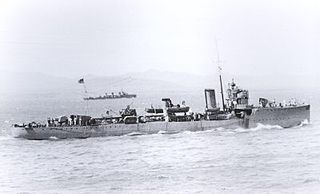
HMS Phoenix was an Acheron-class destroyer of the British Royal Navy. She is named for the mythical bird, and was the fifteenth ship of the Royal Navy to bear the name. She was the only British warship ever to be sunk by the Austro-Hungarian Navy.

Kiwajny is a village in the administrative district of Gmina Górowo Iławeckie, within Bartoszyce County, Warmian-Masurian Voivodeship, in northern Poland, close to the border with the Kaliningrad Oblast of Russia. It lies approximately 13 kilometres (8 mi) north-west of Górowo Iławeckie, 30 km (19 mi) north-west of Bartoszyce, and 66 km (41 mi) north of the regional capital Olsztyn.

Mikado Station is a railway station operated by JR East's Sotobō Line located in Isumi, Chiba Prefecture, Japan. It is 53.7 kilometers from the terminus of the Sotobō Line at Chiba Station.
Dunes-de-Berry Ecological Reserve is an ecological reserve of Quebec, Canada. It was established on December 24, 1996.
The Danish Energy Agency was established in 1975 as an agency of the Danish Ministry of Transport and was in 2007 transferred to the newly created Danish Ministry of Climate and Energy The agency is headquartered in 44 Amaliegade.
The Nho Quế River is a river of Vietnam and China. It flows through Hà Giang Province, Cao Bằng Province and China for 192 kilometres. The river has a basin area of 6052 square kilometres,

Cofton Common is a small area of Birmingham, England, located near Longbridge on the border with Worcestershire.
Dahr-al-Ain is a village in the Koura District of Lebanon, with a Maronite and Greek Orthodox population.
Centro Coyoacán, also known as Centro Comercial Coyoacán, is a shopping mall located on Av. Coyoacán and Av. Universidad in Mexico City, Mexico.

Triumfalnaya Square is a public square in the Tverskoy District of the Central Administrative Okrug of Moscow. It is located in the Garden Ring between the Big Garden street, 1st Brest street and 2nd Brest street, 1st Tverskaya Yamskaya street, Armory alley, Building Arc and Tverskaya Street.
Mill Creek Township is a township in Morgan County, in the U.S. state of Missouri.


