Mallorca, or Majorca, is the largest island in the Balearic Islands, which are part of Spain, and the seventh largest island in the Mediterranean Sea.

The Pityusic Islands, often referenced simply as the Pityuses, or commonly but informally as the Pine Islands, is the name given collectively to the Balearic Islands of Ibiza, Formentera, S'Espalmador and other small islets in the Mediterranean Sea.

A raised beach, coastal terrace, or perched coastline is a relatively flat, horizontal or gently inclined surface of marine origin, mostly an old abrasion platform which has been lifted out of the sphere of wave activity. Thus, it lies above or under the current sea level, depending on the time of its formation. It is bounded by a steeper ascending slope on the landward side and a steeper descending slope on the seaward side. Due to its generally flat shape, it is often used for anthropogenic structures such as settlements and infrastructure.

The Kaikōura Peninsula is located in the northeast of New Zealand's South Island. It protrudes 5 kilometres (3.1 mi) into the Pacific Ocean. The town of Kaikōura is located on the north shore of the peninsula. The peninsula has been settled by Maori for approximately 1000 years, and by Europeans since the 1800s, when whaling operations began off the Kaikōura Coast. Since the end of whaling in 1922 whales have been allowed to thrive and the region is now a popular whale watching destination.
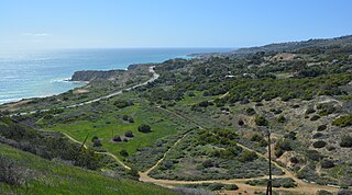
The Portuguese Bend region is the largest area of natural vegetation remaining on the Palos Verdes Peninsula, in Los Angeles County, California. Though once slated for development including the projected route of Crenshaw Boulevard, the area is geologically unstable and is unsuitable for building.
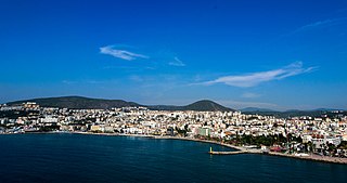
Kuşadası is a large resort town on Turkey's Aegean coast, and the center of the seaside district of the same name within Aydın Province. Kuşadası is 95 km (59 mi) south of İzmir, and about 60 km (37 mi) from Aydın. The municipality's primary industry is tourism. The mayor of the district is Ömer Günel.

Alcúdia (Catalan pronunciation: [əlˈkuðiə]) is a municipality and township of the Spanish autonomous community of the Balearic Islands. It is the main tourist centre in the North of Majorca on the eastern coast. It is a large resort popular with families. Most of the hotels are located in Port d'Alcúdia and Platja d'Alcúdia, along the 14 km (8.7 mi) long beach that stretches all the way to Ca'n Picafort. In Alcúdia, the old town is well preserved with houses dating back to the 13th century. The old town is surrounded by a medieval wall.

Nusa Dua is a resort area built in the 1970s in the southern part of Bali, Indonesia. Known as an enclave of large five-star resorts, it covers 350 hectares of land and encloses more than 20 resorts. It is located 22 kilometers from Denpasar, the provincial capital of Bali, and is administered under South Kuta District, Badung Regency. Nusa Dua means two islands, because there are two islands in the bay of Bali Tourism Development Corporation area. On the southern side lies Peninsula Island, and on the northern side lies Nusa Dharma Island, which is smaller but shadier, and which contains the Pura/Temple Nusa Dharma.
The Cape Metropole has a wide variety of beaches divided into three regions by the Cape Peninsula:

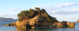
Cap de Formentor is the northernmost point of Majorca, on the Formentor peninsula.
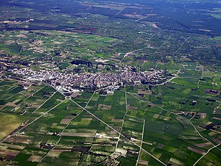
Santa Margalida is a municipality with a population of 10,204 located in the northeast of the Spanish Balearic Island Majorca.

Sant Llorenç des Cardassar is a small municipality on Mallorca, one of the Balearic Islands, Spain.

Playa Grande, also known as Salinas, is a beach community on the Pacific coast of Costa Rica just north of Tamarindo. It is located inside the canton of Santa Cruz in Guanacaste Province. Playa Grande has been part of the Parque Nacional Marino Las Baulas since 1990.

Lilford's wall lizard is a species of lizard in the family Lacertidae. The species is endemic to the Balearic Islands, Spain.
Rodney Bay is a town and bay located in the Gros Islet District on the island of Saint Lucia. Gros Islet is one of the ten districts in the island. It can be found on the northwestern coast of the island above the Castries District, where the capital of St. Lucia is, and the former Dauphin quarter. St. Lucia is a small island in North America located in the Caribbean Sea and it is the largest of the Caribbean's Windward Islands. The Windward islands include Martinique, Saint Vincent and the Grenadines, Barbados, Trinidad and Tobago and Grenada. It is in a chain of islands in the Lesser Antilles with Martinique to the north and Saint Vincent and the Grenadines to the south. These islands are southeast of the islands of Puerto Rico and Haiti. Out of the two airports in St.Lucia, Hewanorra and Charles airport, Rodney Bay is closer to the latter.

Kagoshima Bay also known as Kinkō Bay, Kinko Bay is a deep inlet of the East China Sea on the coast of Japan.

Benzú is a small settlement within the Spanish autonomous city of Ceuta. It has a population of 1,987 according to the 2011 census, divided into two units with Ceuta as its municipality.

The Motobu Peninsula is a peninsula in the Yanbaru region of Okinawa Island. It is surrounded by Nago Bay to the east, the Haneda Inland Sea to the north, and the East China Sea to the west. It is mostly mountainous, with a few plains. The peninsula's northeasternmost point is Cape Bise. Its highest point is Mount Yae, whose summit is 593 metres (1,946 ft). Due to a US military communications tower, the summit is off-limits. The peninsula was the center of power for the kingdom of Hokuzan in medieval times, and was the site of fierce fighting during the Battle of Okinawa in 1945.

The topographical relief of Spain is characterized by being quite high, with an average altitude of 660 meters above sea level, quite mountainous compared to other European countries and only surpassed by Switzerland, Austria, Greece and the microstates of Andorra and Liechtenstein. In peninsular Spain, the terrain is articulated around a large Meseta Central that occupies most of the center of the Iberian Peninsula. Outside the plateau, there is the depression of the Guadalquivir river, located in the southwest of the peninsula, and the Ebro river depression, located in the northeast.