Related Research Articles

Presque Isle County is a county in the Lower Peninsula of the U.S. state of Michigan. As of the 2020 census, the population was 12,982. The county seat is Rogers City. The county was authorized by state legislative action on April 1, 1840, but the county government was not established until 1871. The government was reorganized in 1875.

Alpena County is a county in the U.S. state of Michigan. As of the 2020 census, the population was 28,907. The county seat is Alpena. It is considered to be part of Northern Michigan.
Alpena is a city in the U.S. state of Michigan. It is the county seat of Alpena County, and is the only city within the county. The population was 10,197 at the 2020 census, making it the third most populated city in the Northern Michigan region, after Traverse City and Cadillac. The city is surrounded by Alpena Township, but the two are administered autonomously. It is the core city of the Alpena micropolitan statistical area, which encompasses all of Alpena County and had a total population of 28,907 at the 2020 census.

Ocqueoc Township is a civil township of Presque Isle County in the U.S. state of Michigan named after the Ocqueoc River. The population of Ocqueoc Township was 544 at the 2020 census, down from 655 at the 2010 census.
Onaway is a city in Presque Isle County, just east of the Cheboygan–Presque Isle county line in the U.S. state of Michigan. The population was 880 at the 2010 census. Onaway is the Sturgeon Capital of Michigan, and there is a lake sturgeon streamside rearing facility on the nearby Black River, where the fish migrate down to the Cheboygan River and then to Lake Huron.

Presque Isle Township is a civil township of Presque Isle County in the U.S. state of Michigan. The population was 1,698 at the 2020 census.

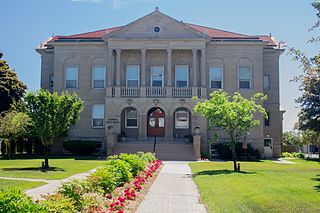
Rogers City is a city in the U.S. state of Michigan. It is the county seat of and largest city in Presque Isle County. The city had a population of 2,850 at the 2020 census, a slight increase from 2,827 at the 2010 census.
Thunder Bay National Marine Sanctuary and Underwater Preserve is a United States National Marine Sanctuary on Lake Huron's Thunder Bay, within the northeastern region of the U.S. state of Michigan. It protects an estimated 116 historically significant shipwrecks ranging from nineteenth-century wooden side-wheelers to twentieth-century steel-hulled steamers. There are a great many wrecks in the sanctuary, and their preservation and protection is a concern for national policymakers. The landward boundary of the sanctuary extends from the western boundary of Presque Isle County to the southern boundary of Alcona County. The sanctuary extends east from the lakeshore to the international border. Alpena is the largest city in the area.

Northern Michigan, also known as Northern Lower Michigan, is a region of the U.S. state of Michigan. A popular tourist destination, it is home to several small- to medium-sized cities, extensive state and national forests, lakes and rivers, and a large portion of Great Lakes shoreline. The region has a significant seasonal population much like other regions that depend on tourism as their main industry. Northern Lower Michigan is distinct from the more northerly Upper Peninsula and Isle Royale, which are also located in "northern" Michigan. In the northernmost 21 counties in the Lower Peninsula of Michigan, the total population of the region is 506,658 people.

P. H. Hoeft State Park is a public recreation area on the shores of Lake Huron, four miles (6.4 km) northwest of Rogers City on US 23 in Presque Isle County, Michigan. The park was added to the National Register of Historic Places in 2009.

Forty Mile Point Light is a lighthouse in Presque Isle County near Hammond Bay on the western shore of Lake Huron in Rogers Township, Michigan USA.
Presque Isle County Advance is a weekly community newspaper that was founded in 1878 by local pioneer Fredrick Denny Larke. It is the most widely read newspaper in Presque Isle County. It is published by Presque Isle Newspapers, which also publishes the Onaway Outlook. The papers are produced from its offices in Rogers City and Onaway, Michigan and serve Presque Isle County, Michigan in the USA. The Presque Isle County Advance covers local news, sports, business and community events.
Long Lake is 5,625-acre (22.76 km2) lake in the U.S. state of Michigan. The lake is within two counties Alpena County and Presque Isle County in Northern Michigan. The lake is the 20th largest inland lake in Michigan.
Grand Lake is a 5,660-acre (22.9 km2)spring fed lake in Presque Isle County in the U.S. state of Michigan. Grand Lake is a substantial lake of approximately 7 miles (11 km) in length and up to 1.5 miles (2.4 km) in width. The lake is on the boundary between Presque Isle Township to the east and Krakow Township to the west, approximately 15 miles (24 km) north of Alpena on U.S. Highway 23, which passes to the south and west of the lake.
Bell River is a short river in Presque Isle County in the U.S. state of Michigan.

Rockport State Recreation Area is a 4,237-acre (17.15 km2) state park located along the shore of Lake Huron in Alpena and Presque Isle counties in the state of Michigan. It is operated by the Michigan Department of Natural Resources and was established in 2012. The park contains limestone formations and an old limestone quarry. There is a deep water boat launch that can accommodate all sizes of watercraft. The park is located along the Lake Huron Flyway and is used to gauge the health of Lake Huron and its shoreline environment. Several ship wrecks can be found off-shore in the Thunder Bay National Marine Sanctuary including the Portland and the Portsmouth. The park was previously known as "The Rockport property" and is not far north of Alpena, Michigan.

Michigan's 36th Senate district is one of 38 districts in the Michigan Senate. The 36th district was created with the adoption of the 1963 Michigan Constitution, as the previous 1908 state constitution only permitted 34 senatorial districts. It has been represented by Republican Michele Hoitenga since 2023, succeeding fellow Republican Jim Stamas.
The Huron Sunrise Trail is a 11-mile (18 km) bicycle and hiking trail in Michigan that follows a section of the shoreline of Lake Huron north and west of Rogers City, Michigan. The trail is entirely contained within Presque Isle County, largely follows a section of the former roadbed of the Detroit and Mackinac Railway.
The Rogers City Branch was a railway line in Presque Isle County, Michigan. It ran north from a junction with the Detroit and Mackinac Railway main line near Posen, Michigan, to Rogers City, Michigan, on the shore of Lake Huron. The Detroit and Mackinac opened the line in 1911, and it was abandoned by the Lake State Railway in 2000. A major customer on the branch was the limestone quarry in Calcite, east of Rogers City.
References
- ↑ Larke, Frederick Denny. "Sections of Presque Isle County Claimed to Abound in Indian Lore". Calcite Screenings, August, 1929. Published by the Michigan Limestone and Chemical Company. Page 19. Accessed at: https://issuu.com/rewar1/docs/1929
- ↑ Discover Heritage Route 23 website http://www.us23heritageroute.org/presque_isle.asp?ait=av&aid=429
- ↑ Michigan Miles, P.H. Hoeft State Park website: http://www.michiganmiles.com/hoeft/
- ↑ Recreation Plan for Presque Isle County, Michigan 2017-2021. Page 19 of Chapter 3 (3-19). Prepared for the Presque Isle County Planning Commission. Viewed at: http://www.discovernortheastmichigan.org/media/assets/media/presque_isle_county_rec_plan_draft_dec_2016.pdf
- ↑ Northeast Michigan Regional Planning and Development Commission. Shoreland Management for Lake Huron and Northeast Michigan, page 67 & 108. Accessed via: https://www.gpo.gov/fdsys/pkg/CZIC-ht168-m5-s56-1976/html/CZIC-ht168-m5-s56-1976.htm
- ↑ Hinsdale, Wilbert B. Spirit Stones. Selections from Papers of the Michigan Academy of Science, Arts and Letters--Vol. 14 – Page 3-4. Viewed at http://www.michigan.gov/documents/deq/GIMDL-MASALV14_302474_7.pdf
- ↑ Powers, Perry F. A History of Northern Michigan and Its People. Page 481. Accessed via University of Michigan Michigan County Histories and Atlases website: http://quod.lib.umich.edu/m/micounty/BAC9250.0001.001?rgn=main;view=fulltext
- ↑ Haltiner, Robert E. Stories the Red People Have Told and More. Published by the author, 2002. ASIN: B01MT391IN. Referenced on Visit Alpena website, "Top 10 Haunted Places", http://www.visitalpena.com/top-10-haunted-places-urban-legends-alpena/