Myitkyina Airport is a public airport in Myitkyina, Myanmar.

The 493d Bombardment Group is a former United States Army Air Forces unit that was assigned to the 92d Bombardment Wing during World War II. It the last bombardment group to be assigned to Eighth Air Force. It flew combat missions in the strategic bombing campaign against Germany until shortly before V-E Day, then returned to the United States for inactivation. In 2002, the group was converted to provisional status as the 493d Air Expeditionary Group and assigned to Air Mobility Command to activate or inactivate as needed.

Lakeland Army Airfield, was a World War II United States Army Air Force located 5.3 miles southwest of Lakeland, Florida. From 1960 to 2017 it was Lakeland Linder Regional Airport. In 2017 it was renamed Lakeland Linder International Airport.
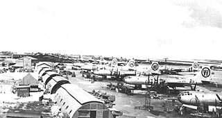
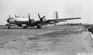
The 505th Bombardment Group is an inactive United States Air Force unit. Its last assignment was with Thirteenth Air Force, stationed at Clark Field, Philippines, where it was inactivated on 30 June 1946. After orgamnizing and training in the United states, the group served in the Pacific Ocean theater of World War II as part of Twentieth Air Force. The group's Boeing B-29 Superfortress engaged in the strategic bombing campaign against Japan from January through August 1945, earning two Distinguished Unit Citations.

Dinjan Airfield, also known as Dinjan Air Force Station, is an air base of Indian Air Force. Established as an air field in World War II, it is located in Dinjan, approximately seven miles northeast of Chabua, in the state of Assam, India.

Dudhkundi Airfield is an abandoned airfield in India, located 12 miles (19.2 km) SE of Jhargram, in the Jhargram district in the Indian state of West Bengal.
Piardoba Airfield is an abandoned airfield in India, located 6.6 miles (10.7 km) S of Bishnupur, West Bengal, Bankura District in the state of West Bengal, India.
Médiouna Airfield is an abandoned military airfield in Morocco, located in the Casablanca area.
Marcianise Airfield is an abandoned World War II military airfield in southeast Italy, which is located approximately 10 km north-northwest of Marcianise in the province of Caserta, Campania; about 32 km north-northwest of Naples. Built in 1943 by United States Army Engineers, the airfield was a large facility capable of handling heavy bombers built for Fifteenth Air Force, which stationed B-17s at the field after the war, prior to their return to the United States. However its primary use was by Air Technical Service Command and by Twelfth Air Force tactical fighter bomber units during the Italian Campaign. The field was used by the senior command of the Mediterranean Theater of Operations based at the Royal Palace of Caserta through 1947.
Athis Airfield was a World War II military airfield located approximately 1 km northeast of Athis, approximately 130 km east-northeast of Paris.
Nampong Air Force Base is a Myanmar Air Force base in Myitkyina, Myanmar (Burma).
Tingkawk Sakan Airfield is a former wartime United States Army Air Forces airfield in Burma used during the Burma Campaign 1944-1945. It is now abandoned.
Dohazari Airfield is a former wartime United States Army Air Forces airfield near Dohazari in Bangladesh used during the Burma Campaign 1944-1945 of World War II. It is now abandoned.
Hailakandi Airfield is a former wartime United States Army Air Forces airfield in India, used during the Burma Campaign 1944–1945. It is now abandoned. Hailakandi is a district of the Indian state of Assam.
Hathazari Airfield is a former wartime United States Army Air Forces airfield in Bangladesh that was used during the Burma Campaign in 1945. It is no longer in use.
Pandaveswar Airfield is a former wartime United States Army Air Forces airfield in India used during the Burma Campaign 1944-1945. It is now abandoned.
Nawadih Airfield is a former wartime United States Army Air Forces airfield in India used during the Burma Campaign 1944-1945. It is now abandoned.
Fenny Airfield or Feni Airfield is a former wartime United States Army Air Forces airfield located in Feni District, Bangladesh used during the Burma Campaign 1944-1945 of World War II. The airfield is now abandoned.
Guskhara Airfield is a former wartime United States Army Air Forces airfield in India used during the Burma Campaign 1944-1945. It is now abandoned.
Asansol Airfield is a former wartime Royal Air Force Station and later used by the United States Army Air Forces airfield in Asansol, India used during the Burma Campaign 1944-1945. It is located near Nigah village on NH 2/ Grand Trunk Road.