
The Blue Line is a 26.93-mile-long (43.34 km) Chicago "L" line which extends through The Loop from O'Hare International Airport at the far northwest end of the city, through downtown via the Milwaukee–Dearborn subway and across the West Side to its southwest end at Forest Park, with a total of 33 stations. It is the longest line on the "L" system and second busiest, with an average of 47,120 passengers boarding each weekday in 2021.
The John F. Kennedy Expressway is a nearly 18-mile-long (29 km) freeway in Chicago, Illinois, United States. Portions of the freeway carry I-190, I-90 and I-94. The freeway runs in a southeast–northwest direction between the central city neighborhood of the West Loop and O'Hare International Airport. The highway was named in commemoration of 35th US President John F. Kennedy. It conforms to the Chicago-area term of using the word expressway for an Interstate Highway without tolls. The Kennedy's official endpoints are the Jane Byrne Interchange with Interstate 290 and the Dan Ryan Expressway at the east end, and the O'Hare Airport terminals at the west end. I-190 runs from the western terminus at O'Hare Airport for 3.07 miles (4.94 km), where it meets I-90 and runs a further 6.29 miles (10.12 km), before joining with I-94 for the final 8.44 miles (13.58 km).
The Southwest Corridor or Southwest Expressway was a project designed to bring an eight-lane highway into the City of Boston from a direction southwesterly of downtown. It was supposed to connect with Interstate 95 (I-95) at Route 128. As originally designed, it would have followed the right of way of the former Penn Central/New Haven Railroad mainline running from Readville, north through Roslindale, Forest Hills and Jamaica Plain, where it would have met the also-cancelled I-695. The 50-foot-wide median for the uncompleted "Southwest Expressway" would have carried the southwest stretch of the MBTA Orange Line within it, replacing the Washington Street Elevated railway's 1901/1909-built elevated railbed. Another highway, the four-lane South End Bypass, was proposed to run along the railroad corridor between I-695 in Roxbury and I-90 near Back Bay.

Interstate 676 (I-676) is an Interstate Highway that serves as a major thoroughfare through Center City Philadelphia, where it is known as the Vine Street Expressway, and Camden, New Jersey, where it is known as the northern segment of the North–South Freeway, as well as the Martin Luther King Jr. Memorial Highway in honor of civil rights leader Martin Luther King Jr. Its western terminus is at I-76 in Philadelphia near the Philadelphia Museum of Art and Fairmount Park. From there, it heads east and is then routed on surface streets near Franklin Square and Independence National Historical Park, home of the Liberty Bell, before crossing the Delaware River on the Benjamin Franklin Bridge. On the New Jersey side of the bridge, the highway heads south to its southern terminus at I-76 in Gloucester City near the Walt Whitman Bridge. Between the western terminus and downtown Camden, I-676 is concurrent with U.S. Route 30 (US 30).

The Inner Belt in Boston was a planned six-lane, limited-access highway that would have run through parts of Boston, Brookline, Cambridge, and Somerville.
The Central Artery is a section of freeway in downtown Boston, Massachusetts; it is designated as Interstate 93, US 1 and Route 3.
The Quartier international de Montréal (QIM) or Montreal's International District is a district of the Ville-Marie borough in the city's downtown core of Montreal, Quebec, Canada. It is roughly bordered by René-Levesque Boulevard to the north, Notre-Dame Street to the south, De Bleury/Saint-Pierre Street to the east and Robert-Bourassa Boulevard to the west. The Palais des congrès building lying just east of the district is also usually comprised in it. Constructed dispersedly between 1965 and 1985 in place of older colonial housing blocks, the district underwent major urban renewal as a central business district in 2000–2003.

Vanak is a neighbourhood in the northern part of Tehran, capital of Iran and there is a square and a street named after it. The word Vanak means "Small (ash) Tree" in Persian.

Shahid Chamran Expressway, Also known as Parkway Expressway is an expressway in Tehran, Iran, leading from Tohid Square to Parkway Junction. Chamran is the oldest expressway in Tehran, and is unofficially called Parkway Expressway or just Parkway for short. The expressway is named after Mostafa Chamran.

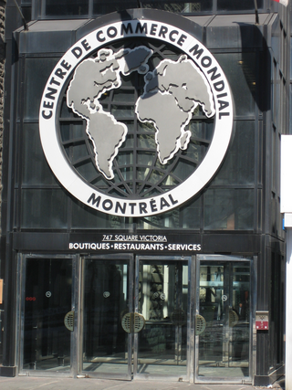
Saint Antoine Street, formerly known as Craig Street, is a street located in Montreal, Quebec, Canada. It runs to the south of Downtown Montreal and north of Old Montreal and Griffintown and Saint-Henri. It crosses the Quartier international de Montréal.
Shahid Haghani Expressway (Highway) is an expressway in Tehran. It starts from Resalat Expressway and ends in Vanak Square.
Kazemi Expressway starts from Zam-zam Square and goes south and ends in Jahad Square.

Cheraghi Expressway, formerly Javaneh Expressway is a road system that starts from Navvab Expressway and Qale Morghi Expressway. It runs from beside Qale Morghi Airport and ends in Zam-zam Square in Tehran, Iran.
East Bayfront, or the East Bayfront Precinct, is an emerging neighbourhood in Toronto, Ontario, Canada. It is currently undergoing a transformation from industrial use to mixed-use as part of Waterfront Toronto's plans to create a residential and commercial district urban core near the lake.
Tehran Metro Line 3 travels from northeast to southwest. Line 3 is one of the most important lines as it connects southwest Tehran to northeast, crosses busy parts of the capital city, and can help to alleviate traffic problems. About 7 kilometers (4.3 mi) of Line 3 became operational in December 2012, followed by 12 kilometers (7.5 mi) in April 2014, and finally, the last section of the line which is 18 kilometers (11 mi) opened on September 22, 2015, increasing the length of the line to a total of 33.7 kilometers (20.9 mi).

Line 4 is one of several lines of the Tehran Metro. The line is 23.0 km (14.3 mi) with 19 main stations, 3 stations along a domestic airport-serving branch line and a terminal (depôt).
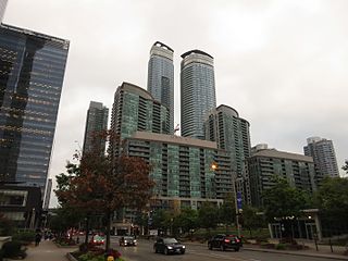
South Core is a neighbourhood located in downtown Toronto, Ontario, Canada. The South Core occupies the eastern portions of the Railway Lands. The remodeling and restoration of Union Station and the construction of a new wave of business and condominium towers is central to this area's forecast growth.
"Forecasters expect the downtown population to grow 80 per cent to 130,000 by 2031. With the financial district just to the north and the new high-rise South Core on the other side, Union is right at the centre."

Macri Triangle is a 0.57 acres park located at the intersection of Meeker Avenue, Union Avenue, and Metropolitan Avenue in Williamsburg, Brooklyn, New York City. The property was designated as a park in 1946 during the construction of the Brooklyn-Queens Expressway, which resulted in the demolition of buildings along its route and the extension of Meeker Avenue from Richardson Street south to Metropolitan Avenue, serving as the expressway's service road. As the highway ran through the street grid, triangular parcels that were too small to be developed were designated as public plazas, including this one.


