Saint-Alexis-des-Monts

Last updated

Saint-Alexis-des-Monts
Eglise Saint-Alexis 01.jpg
Saint-Alexis Church
Motto: 
Progrès et Harmonie
Saint-Alexis-des-Monts Quebec location diagram.png
Location within Maskinongé RCM.
Canada Central Quebec location map.png
Red pog.svg
Saint-Alexis-des-Monts
Location in central Quebec.
Coordinates: 46°28′N73°08′W / 46.467°N 73.133°W / 46.467; -73.133 [1]
CountryFlag of Canada (Pantone).svg  Canada
Province Flag of Quebec.svg  Quebec
Region Mauricie
RCM Maskinongé
Settled1865
ConstitutedApril 21, 1984
Government
[2]
  MayorMichel Bourassa
   Federal riding Berthier—Maskinongé
   Prov. riding Maskinongé
Area
  Total1,135.80 km2 (438.53 sq mi)
  Land1,035.74 km2 (399.90 sq mi)
Population
 (2021) [3]
  Total2,999
  Density2.9/km2 (8/sq mi)
  Pop 2016-2021
Increase2.svg 0.6%
  Dwellings
2,136
Time zone UTC−5 (EST)
  Summer (DST) UTC−4 (EDT)
Postal code(s)
Area code 819
HighwaysQc349.svg R-349
Website www.saint-
alexis-des-monts.ca

Saint-Alexis-des-Monts is a parish municipality in the Mauricie region of the province of Quebec in Canada.

Contents

It is located in the Laurentian Mountains, having a topography that is characterized by valleys and rounded hills, with an altitude varying between 150 metres (490 ft) to 560 metres (1,840 ft). There are more than 600 lakes, 400 named and another 200 unnamed minor lakes. [4] The majority (65%) of its territory is part of the Matawin Wildlife Reserve. The town depends on outdoor tourism that increases its seasonal population to between 8000 and 10,000 persons. [5]

History

The first settlers were originally from Saint-Paulin and established the community on the banks of the Du Loup River, north-west of Saint-Paulin, around 1865. On October 30 of that year, Alexis Lefebvre Boulanger (1812-1885), pioneer and farmer, donated the land on which the village's chapel was built in 1867, and the church in 1884. Saint-Alexis was named after him. [1]

Its post office, identified as Saint-Alexis-des-Monts, opened in 1876. In 1877, the Parish Municipality of Saint-Alexis-des-Monts was formed. [1]

In 1973, a portion of Saint-Alexis-des-Monts separated and formed the Municipality of Belleau, named in honour of Sir Narcisse-Fortunat Belleau (1808-1894), former lieutenant-governor of Quebec. On April 21, 1984, Belleau rejoined Saint-Alexis-des-Monts again, and the parish municipality had a surface area of more than 500 square kilometres (190 sq mi). On December 9, 1995, 763 square kilometres (295 sq mi) was added following the annexation of the Lac-Marcotte and Lac-au-Sorcier unorganized territories. [1]

Demographics

In the 2021 Census of Population conducted by Statistics Canada, Saint-Alexis-des-Monts had a population of 2,999 living in 1,593 of its 2,136 total private dwellings, a change of 0.6% from its 2016 population of 2,981. With a land area of 1,035.74 km2 (399.90 sq mi), it had a population density of 2.9/km2 (7.5/sq mi) in 2021. [6]

Canada census – Saint-Alexis-des-Monts community profile
2021 2016 2011
Population2,999 (+0.6% from 2016)2,981 (-2.1% from 2011)3,046 (-2.3% from 2006)
Land area1,035.74 km2 (399.90 sq mi)1,048.39 km2 (404.79 sq mi)1,048.28 km2 (404.74 sq mi)
Population density2.9/km2 (7.5/sq mi)2.8/km2 (7.3/sq mi)2.9/km2 (7.5/sq mi)
Median age59.2 (M: 60.0, F: 58.8)56.3 (M: 56.6, F: 55.9)52.5 (M: 52.3, F: 52.9)
Private dwellings2,136 (total) 2,149 (total) 2,036 (total) 
Median household income$50,000$41,216$36,984
References: 2021 [7] 2016 [8] 2011 [9] earlier [10] [11]

Population trend: [12]

Mother tongue:

Related Research Articles

<span class="mw-page-title-main">Maskinongé Regional County Municipality</span> Regional county municipality in Quebec, Canada

Maskinongé is a regional county municipality in the Mauricie region of Quebec, Canada. The seat is Louiseville. It is located adjacent on the west of Trois-Rivières on the Saint Lawrence River.

<span class="mw-page-title-main">Mont-Tremblant</span> City in Quebec, Canada

Mont-Tremblant is a city in the Laurentian Mountains of Quebec, Canada, approximately 130 kilometres (81 mi) northwest of Montreal and 140 kilometres (87 mi) northeast of Ottawa, Ontario. The current municipality with city status was formed in 2000. Mont-Tremblant is most famous for its ski resort, the Mont-Tremblant Ski Resort, which is seven kilometres from the village proper, at the foot of a mountain called Mont Tremblant.

<span class="mw-page-title-main">Notre-Dame-des-Anges, Quebec</span> Parish municipality in Quebec, Canada

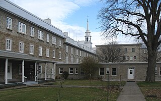
Notre-Dame-des-Anges is a parish municipality in Quebec, Canada, home of the General Hospital of Quebec.

<span class="mw-page-title-main">Saint-Léon-le-Grand, Mauricie</span> Parish municipality in Quebec, Canada

Saint-Léon-le-Grand is a parish municipality in the Maskinongé Regional County Municipality in the Mauricie region of the province of Quebec, Canada.

<span class="mw-page-title-main">Saint-Maurice, Quebec</span> Parish municipality in Quebec, Canada

Saint-Maurice is a parish municipality in the Mauricie region of the province of Quebec in Canada.

<span class="mw-page-title-main">Saint-Édouard-de-Fabre</span> Parish municipality in Quebec, Canada

Saint-Édouard-de-Fabre is a parish municipality in western Quebec, Canada, in the Témiscamingue Regional County Municipality.

<span class="mw-page-title-main">Senneterre, Quebec (parish)</span> Parish municipality in Quebec, Canada

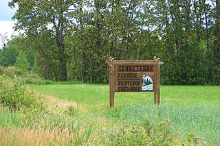
Senneterre is a parish municipality in northwestern Quebec, Canada, in the La Vallée-de-l'Or Regional County Municipality. The parish is mostly a rural municipality that almost completely surrounds the actual population centre of the neighbouring City of Senneterre.

<span class="mw-page-title-main">Saint-Adelme, Quebec</span> Parish municipality in Quebec, Canada

Saint-Adelme is a parish municipality in the Canadian province of Quebec, located in La Matanie Regional County Municipality in the Bas-Saint-Laurent region.

<span class="mw-page-title-main">Saint-Jean-de-Cherbourg</span> Parish municipality in Quebec, Canada

Saint-Jean-de-Cherbourg is a parish municipality in the Canadian province of Quebec, located in La Matanie Regional County Municipality.

<span class="mw-page-title-main">Saint-Damien, Quebec</span> Parish municipality in Quebec, Canada

Saint-Damien is a parish municipality of 2,393 inhabitants in Quebec, Canada. It is located in Matawinie Regional County Municipality in the Lanaudière region.

<span class="mw-page-title-main">Mont-Saint-Michel, Quebec</span> Municipality in Quebec, Canada

Mont-Saint-Michel is a municipality in the Laurentides region of Quebec, Canada, part of the Antoine-Labelle Regional County Municipality.

<span class="mw-page-title-main">Saint-Sulpice, Quebec</span> Parish municipality in Quebec, Canada

Saint-Sulpice is a municipality in the Lanaudière region of Quebec, Canada, part of the L'Assomption Regional County Municipality. It is located on the north shore of the Saint Lawrence River and includes most of Verchères Islands.

<span class="mw-page-title-main">Saint-Gabriel, Quebec</span> City in Quebec, Canada

Saint-Gabriel is a town in the Lanaudière region of Quebec, Canada, part of the D'Autray Regional County Municipality. It is located on the shores of Lake Maskinongé, in the shadows of the Laurentian Mountains.

<span class="mw-page-title-main">Saint-Siméon, Gaspésie–Îles-de-la-Madeleine, Quebec</span> Parish municipality in Quebec, Canada

Saint-Siméon is a parish municipality in Quebec, Canada. It is also sometimes called Saint-Siméon-de-Bonaventure to avoid confusion with Saint-Siméon in the Capitale-Nationale region.

<span class="mw-page-title-main">Saint-Tharcisius</span> Parish municipality in Quebec, Canada

Saint-Tharcisius is a parish municipality in Quebec, Canada.

<span class="mw-page-title-main">Saint-Joseph-de-Lepage</span> Parish municipality in Quebec, Canada

Saint-Joseph-de-Lepage is a parish municipality in La Mitis Regional County Municipality in the Bas-Saint-Laurent region of Quebec, Canada.

<span class="mw-page-title-main">Saint-Joachim, Quebec</span> Parish municipality in Quebec, Canada

Saint-Joachim is a parish municipality in Quebec, Canada. It is part of the La Côte-de-Beaupré Regional County Municipality in the Capitale-Nationale region. Located at the foot of Cape Tourmente, it is home to the Cap Tourmente National Wildlife Area and Canyon Sainte-Anne.

<span class="mw-page-title-main">La Doré, Quebec</span> Parish municipality in Quebec, Canada

La Doré is a parish municipality in Quebec, Canada, in the regional county municipality of Le Domaine-du-Roy and the administrative region of Saguenay–Lac-Saint-Jean.

<span class="mw-page-title-main">L'Ascension-de-Notre-Seigneur, Quebec</span> Parish municipality in Quebec, Canada

L'Ascension-de-Notre-Seigneur is a parish municipality in Quebec, Canada, located within the regional county municipality of Lac-Saint-Jean-Est in the Saguenay-Lac-Saint-Jean region. Its name is French for "the Ascension of Our Lord".

<span class="mw-page-title-main">Ragueneau, Quebec</span> Parish municipality in Quebec, Canada

Ragueneau is a parish municipality located on Outardes Bay, on the north shore of the maritime estuary of the St. Lawrence River, in Côte-Nord region, Manicouagan RCM, in Quebec, Canada.

References

  1. 1 2 3 4 "Saint-Alexis-des-Monts (Municipalité de paroisse)" (in French). Commission de toponymie du Québec. Retrieved 2010-02-08.
  2. 1 2 "Répertoire des municipalités: Geographic code 51065". www.mamh.gouv.qc.ca (in French). Ministère des Affaires municipales et de l'Habitation.
  3. 1 2 "Census Profile, 2021 Census - Saint-Alexis-des-Monts, Quebec". 15 November 2023.
  4. "Saint-Alexis-des-Monts en quelques chiffres" (in French). Municipalité de Saint-Alexis-des-Monts. Archived from the original on 2010-01-28. Retrieved 2010-02-08.
  5. "La Municipalité" (in French). Municipalité de Saint-Alexis-des-Monts. Archived from the original on 2010-01-28. Retrieved 2010-02-08.
  6. "Population and dwelling counts: Canada, provinces and territories, and census subdivisions (municipalities), Quebec". Statistics Canada. February 9, 2022. Retrieved August 29, 2022.
  7. "2021 Community Profiles". 2021 Canadian Census . Statistics Canada. February 4, 2022. Retrieved 2024-07-07.
  8. "2016 Community Profiles". 2016 Canadian Census . Statistics Canada. August 12, 2021. Retrieved 2022-07-29.
  9. "2011 Community Profiles". 2011 Canadian Census . Statistics Canada. March 21, 2019. Retrieved 2022-07-29.
  10. "2006 Community Profiles". 2006 Canadian Census . Statistics Canada. August 20, 2019.
  11. "2001 Community Profiles". 2001 Canadian Census . Statistics Canada. July 18, 2021.
  12. Statistics Canada: 1996, 2001, 2006, 2011, 2016, 2021 census