La Prairie is an off-island suburb of Montreal, in southwestern Quebec, Canada, at the confluence of the Saint-Jacques River and the Saint Lawrence River in the Regional County Municipality of Roussillon. The population as of the Canada 2011 Census was 23,357.

Melbourne is a township municipality located in Le Val-Saint-François Regional County Municipality in the Estrie region of Quebec, Canada.
Saint-François is the French form of Saint Francis, and is the name of many locations:
Beauceville is a city in, and the seat of, the Municipalité régionale de comté Robert-Cliche in Quebec, Canada. It is part of the Chaudière-Appalaches region and the population was 6,354 as of the Canada 2011 Census.
Saint-Odilon-de-Cranbourne is a parish municipality in Robert-Cliche Regional County Municipality the Chaudière-Appalaches region of Quebec, Canada. Its population is 1,459 as of the Canada 2011 Census. The parish's name honours Reverend Pierre-François-Xavier-Odilon-Marie-Alphonse Paradis, first priest of Saint-Odilon-de-Cranbourne, while "Cranbourne" comes from Cranborne, a village in East Dorset, England.

Route 291 is 55 km two-lane north/south highway in Quebec, Canada, which starts in Rivière-du-Loup at the junction of Route 132 just east of Autoroute 20 and ends in Saint-Honoré-de-Témiscouata at the junction of Route 185.

Bonsecours is a municipality in Le Val-Saint-François Regional County Municipality in the Estrie region of Quebec, Canada.

Weedon is a municipality of 2,683 people in Le Haut-Saint-François Regional County Municipality, in Quebec, Canada.

Saint-Isidore-de-Clifton is a municipality of 800 people in Le Haut-Saint-François Regional County Municipality, in Quebec, Canada on the Canada–United States border.
François-Pierre Bruneau was a lawyer, seigneur, businessman and political figure in Canada East.

Sainte-Geneviève-de-Batiscan is a parish municipality in the Mauricie region of the province of Quebec in Canada. This municipality is part of the Les Chenaux Regional County Municipality in Batiscanie and in the administrative region of Mauricie. It is located along the Batiscan River.

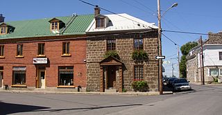
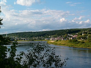
Batiscan is a municipality in the Mauricie region of the province of Quebec in Canada. It is located along the Saint Lawrence River at the mouth of the Batiscan River.
Valcourt is a township municipality in the Canadian province of Quebec, located within the Le Val-Saint-François Regional County Municipality. The township had a population of 1,047 in the Canada 2011 Census.

Wentworth-Nord is a municipality in the Laurentides region of Quebec, Canada, part of the Les Pays-d'en-Haut Regional County Municipality.

Saint-François-de-l'Île-d'Orléans is a municipality in the Capitale-Nationale region of Quebec, Canada, part of the L'Île-d'Orléans Regional County Municipality. The village is situated on the north-eastern tip of Orléans Island, and the municipality also includes the Madame and Ruau Islands, part of the Montmagny Archipelago.

Petite-Rivière-Saint-François is a municipality in Quebec, Canada, along the Saint Lawrence River. It is considered the gateway to the Charlevoix region.

Saint-François-de-la-Rivière-du-Sud is a municipality in Quebec.

Saint-François-Xavier-de-Brompton is a municipality in Le Val-Saint-François Regional County Municipality in the Estrie region of Quebec, Canada. Prior to November 16, 2013 it was a parish municipality.
Saint-François, Quebec may refer to:

Whitworth is an Indian reserve in the Bas-Saint-Laurent region of Quebec. It is geographically located within the territory of Rivière-du-Loup Regional County Municipality but is not legally part of it. Its population was 0 in the Canada 2006 Census and it appears to have been left out of the Canada 2011 Census.


