Saint-Gérard-Majella, Quebec

Last updated
Saint-Gérard-Majella
Parish municipality
Saint-Gerard-Majella Quebec location diagram.PNG
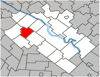
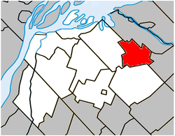
Location within Pierre-De Saurel RCM.
Canada Southern Quebec location map.png
Red pog.svg
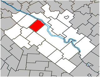
Saint-Gérard-Majella
Location in southern Quebec.
Coordinates: 46°00′N72°50′W / 46.000°N 72.833°W / 46.000; -72.833 Coordinates: 46°00′N72°50′W / 46.000°N 72.833°W / 46.000; -72.833 [1]
CountryFlag of Canada.svg  Canada
Province Flag of Quebec.svg  Quebec
Region Montérégie
RCM Pierre-De Saurel
Constituted February 18, 1907
Named for Gerard Majella [1]
Government [2] [3]
  Mayor Charles Lachapelle
   Federal riding Bas-Richelieu—Nicolet—Bécancour
   Prov. riding Richelieu
Area [2] [4]
  Total 38.20 km2 (14.75 sq mi)
  Land 38.21 km2 (14.75 sq mi)
 There is an apparent
contradiction between two
authoritative sources
Population (2011) [4]
  Total 246
  Density 6.4/km2 (17/sq mi)
  Pop 2006-2011Decrease2.svg 2.4%
  Dwellings 109
Time zone EST (UTC−5)
  Summer (DST) EDT (UTC−4)
Postal code(s) J0G 1X1
Area code(s) 450 and 579
HighwaysQc122.svg Route 122
Qc132.svg Route 132

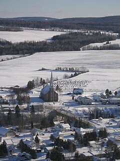
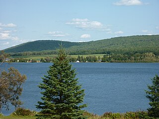
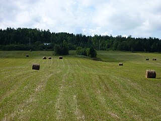
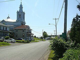
Saint-Gérard-Majella is a parish municipality located in the Pierre-De Saurel Regional County Municipality of Québec (Canada), in the administrative region of Montérégie. The population as of the Canada 2011 Census was 246.

Pierre-De Saurel Regional County Municipality Regional county municipality in Quebec, Canada

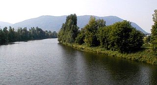
Pierre-De Saurel is a regional county municipality in the Montérégie region in southwestern Quebec, Canada. Originally named Le Bas-Richelieu Regional County Municipality, the name change to Pierre-De Saurel took effect on January 1, 2009. Its seat is in Sorel-Tracy. It is located on the Richelieu River, downstream from La Vallée-du-Richelieu Regional County Municipality at the confluence of the Richelieu and Saint Lawrence River.

Canada Country in North America

Canada is a country in the northern part of North America. Its ten provinces and three territories extend from the Atlantic to the Pacific and northward into the Arctic Ocean, covering 9.98 million square kilometres, making it the world's second-largest country by total area. Canada's southern border with the United States is the world's longest bi-national land border. Its capital is Ottawa, and its three largest metropolitan areas are Toronto, Montreal, and Vancouver. As a whole, Canada is sparsely populated, the majority of its land area being dominated by forest and tundra. Consequently, its population is highly urbanized, with over 80 percent of its inhabitants concentrated in large and medium-sized cities, many near the southern border. Canada's climate varies widely across its vast area, ranging from arctic weather in the north, to hot summers in the southern regions, with four distinct seasons.

Montérégie Administrative region in Quebec, Canada

Montérégie is an administrative region in the southwest part of Quebec. It includes the cities of Boucherville, Brossard, Granby, Longueuil, Salaberry-de-Valleyfield, Saint-Jean-sur-Richelieu, Saint-Hyacinthe, Sorel-Tracy, and Vaudreuil-Dorion.

Contents

Demographics

See also

Related Research Articles

LAssomption, Quebec City in Quebec, Canada

L'Assomption is an off-island suburb of Montreal, in southwestern Quebec, Canada on the L'Assomption River. It is the seat of the Regional County Municipality of L'Assomption. It is located on the outer fringes of the Montreal urban area.

Saint-Nazaire-dActon, Quebec Parish municipality in Quebec, Canada

Saint-Nazaire-d'Acton is a parish municipality in central Quebec, Canada in Acton Regional County Municipality. The population as of the Canada 2011 Census was 826.

Saint-Ours, Quebec City in Quebec, Canada

Saint-Ours is a city located in the Pierre-De Saurel Regional County Municipality of Québec (Canada), in the administrative region of Montérégie. The population as of the Canada 2011 Census was 1,721. Founded in 1650 and originally constituent of the Saint-Ours Parish Municipality, which merged alongside L'Immaculée-Conception-de-Saint-Ours municipality in 1991, Saint-Ours is one of the earliest settlements in Montérégie.

Saint-Pie, Quebec City in Quebec, Canada

Saint-Pie is a city in the Montérégie region of southwest Quebec. The population as of the Canada 2011 Census was 5,438.

Saint-Jean-de-Cherbourg Parish municipality in Quebec, Canada

Saint-Jean-de-Cherbourg is a parish municipality in the Canadian province of Quebec, located in La Matanie Regional County Municipality.

Causapscal City in Quebec, Canada

Causapscal is a city in the Canadian province of Quebec, located in La Matapédia Regional County Municipality. It is located at the confluence of the Matapédia and Causapscal Rivers, along Quebec Route 132, approximately halfway between Mont-Joli and Campbellton, New Brunswick. It is served by the Causapscal railway station and the Causapscal Airport.

Saint-Louis-de-Gonzague, Montérégie, Quebec Parish municipality in Quebec, Canada

Saint-Louis-de-Gonzague is a parish municipality in the Beauharnois-Salaberry Regional County Municipality in the Montérégie region of Quebec, Canada. The population as of the Canada 2011 Census was 1,389.

Saint-Isidore, Montérégie, Quebec Parish municipality in Quebec, Canada

Saint-Isidore is a parish municipality in Roussillon Regional County Municipality in the Montérégie administrative region of Quebec, Canada. The population as of the Canada 2011 Census was 2,581. It is the hometown of mixed martial arts champion Georges St-Pierre.

Saint-Edmond-de-Grantham Parish municipality in Quebec, Canada

Saint-Edmond-de-Grantham is a parish municipality in the Centre-du-Québec region of Quebec. The population as of the Canada 2011 Census was 673.

Saint-Majorique-de-Grantham Parish municipality in Quebec, Canada

Saint-Majorique-de-Grantham is a parish municipality in the Centre-du-Québec region of Quebec. The population as of the Canada 2011 Census was 1,251.

Saint-Pie-de-Guire, Quebec Parish municipality in Quebec, Canada

Saint-Pie-de-Guire is a parish municipality in the Centre-du-Québec region of southwestern Quebec. The population as of the Canada 2011 Census was 456.

Saint-Lucien, Quebec Municipality in Quebec, Canada

Saint-Lucien is a municipality in the Drummond Regional County Municipality in the Centre-du-Quebec region of Quebec. The population as of the Canada 2011 Census was 1,584.

Saint-Elphège, Quebec Parish municipality in Quebec, Canada

Saint-Elphège is a parish municipality located on the east bank of the Saint-François River in the Nicolet-Yamaska Regional County Municipality of Quebec, Canada. The population as of the Canada 2011 Census was 292.

Saint-Zéphirin-de-Courval, Quebec Parish municipality in Quebec, Canada

Saint-Zéphirin-de-Courval is a parish municipality located in the Nicolet-Yamaska Regional County Municipality of Quebec. The population as of the Canada 2011 Census was 737.

Saint-Siméon, Gaspésie–Îles-de-la-Madeleine, Quebec Parish municipality in Quebec, Canada

Saint-Siméon is a parish municipality in Quebec, Canada. It is also sometimes called Saint-Siméon-de-Bonaventure to avoid confusion with Saint-Siméon in the Capitale-Nationale region.

Saint-Léon-le-Grand, Bas-Saint-Laurent, Quebec Parish municipality in Quebec, Canada

Saint-Léon-le-Grand is a parish municipality in Quebec, Canada.

Saint-Zénon-du-Lac-Humqui, Quebec Parish municipality in Quebec, Canada

Saint-Zénon-du-Lac-Humqui is a parish municipality in Quebec, Canada.

Saint-Alexandre-des-Lacs, Quebec Parish municipality in Quebec, Canada

Saint-Alexandre-des-Lacs is a parish municipality in Quebec, Canada.

Saint-Moïse, Quebec Parish municipality in Quebec, Canada

Saint-Moïse is a parish municipality in Quebec, Canada. It is located at the intersection of routes 132 and 297.

Saint-Damase, Bas-Saint-Laurent, Quebec Parish municipality in Quebec, Canada

Saint-Damase is a parish municipality in Quebec, Canada.

References