Saint-Luc-de-Vincennes, Quebec

Last updated

Saint-Luc-de-Vincennes
Saint-Luc-de-Vincennes.jpg
Presbytery St-Laurent-de-la-Moraine Parish, [1] rue de l'Église
Saint-Luc-de-Vincennes Quebec location diagram.png
Location within Les Chenaux RCM.
Canada Central Quebec location map.png
Red pog.svg
Saint-Luc-de-Vincennes
Location in central Quebec.
Coordinates: 46°30′N72°25′W / 46.500°N 72.417°W / 46.500; -72.417
CountryFlag of Canada (Pantone).svg  Canada
Province Flag of Quebec.svg  Quebec
Region Mauricie
RCM Les Chenaux
ConstitutedJanuary 19, 1865
Government
[2]
  MayorDaniel Houle
   Federal riding Saint-Maurice—Champlain
   Prov. riding Champlain
Area
  Total54.20 km2 (20.93 sq mi)
  Land54.15 km2 (20.91 sq mi)
Population
 (2011)
  Total591
  Density10.9/km2 (28/sq mi)
  Pop 2006-2011
Increase2.svg 6.9%
  Dwellings
273
Time zone UTC−5 (EST)
  Summer (DST) UTC−4 (EDT)
Postal code(s)
Area code 819
Highways
Quebec Autoroute 40.svg A-40

Qc352.svg R-352
Qc359.svg R-359
Website www.stluc
devincennes.com

Saint-Luc-de-Vincennes is a municipality in the Mauricie region of the province of Quebec in Canada. It is the seat of the RCM of Les Chenaux. [4]

Contents

History

Detached from Saint-Narcisse and Champlain in 1865, the parish municipality of Saint-Luc changed its status to that of municipality of Saint-Luc-de-Vincennes in 1991. [4]

Saint-Luc-de-Vincennes, a nurturing community During the Covid-19 pandemic (more or less: 2019-2023), the community of Saint-Luc-de-Vincennes was active around several spontaneous projects: the construction of a bread oven, the inoculation of mushrooms on logs, the planting of fruit shrubs, the cultivation of a community garden, the installation of beehives. Source: A dream takes shape in Saint-Luc-de-Vincennes [5] .

Geography

The composition of the soil of Saint-Luc-de-Vincennes includes clay at depth, it favours landslides: those of 1823, 1878, 1895, 1981 and 1986 2016 are among the most remarkable. [6] [7]

On 9 November 2016, a landslide in sensitive glaciomarine sediments occurred on a terrace of the Champlain River near the municipality of Saint-Luc-de-Vincennes, Quebec. The particularity of this event is that there are evidences that the movement started as a flowslide and then finished as a spread. The landslide morphology comprises horsts and grabens typical of spreads and also a large quantity of remolded material that flowed out of a pear-shaped crater with a narrow bottleneck, typical of flowslides. The geotechnical investigation of this landslide was performed by the Ministère des Transports du Québec (MTQ) in collaboration with Université Laval, and consisted of light detection and ranging (LiDAR) surveys, drone photography, several boreholes, piezocone tests with pore pressure measurements (CPTUs), field vane tests, and piezometric monitoring. Source: Canadian science publishing [7]

Demographics

Population trend: [8]

Private dwellings occupied by usual residents: 261 (total dwellings: 273)

Mother tongue:

Photos

See also

St-Laurent-de-la-Moraine Parish / St-Luc-de-Vincennes Church [1]

Related Research Articles

<span class="mw-page-title-main">Saint-Tite</span> City in Quebec, Canada

Saint-Tite is a Canadian city located at the foothills of the Laurentians, between Grandes-Piles and Saint-Adelphe, in the Mauricie RCM of Mékinac. A large body of water, Lake Pierre-Paul, bathes the northeastern part of the territory.'

Francheville was a former regional county municipality in the Mauricie region of Quebec, Canada. Prior to its dissolution, it had an area of 1,124 square kilometres (434 sq mi).

<span class="mw-page-title-main">Les Chenaux Regional County Municipality</span> Regional county municipality in Quebec, Canada

Les Chenaux is a regional county municipality in central Quebec, Canada, in the Mauricie region. The seat is in Saint-Luc-de-Vincennes. It is located adjacent on the east of Trois-Rivières on the Saint Lawrence River. It has a land area of 872.04 square kilometres (336.70 sq mi) and a population of 17,865 inhabitants in the Canada 2011 Census. Its largest community is the parish of Notre-Dame-du-Mont-Carmel.

<span class="mw-page-title-main">Notre-Dame-du-Mont-Carmel, Quebec</span> Parish municipality in Quebec, Canada

Notre-Dame-du-Mont-Carmel in the Mauricie region of the province of Quebec in Canada.

<span class="mw-page-title-main">Sainte-Anne-de-la-Pérade</span> Municipality in Quebec, Canada

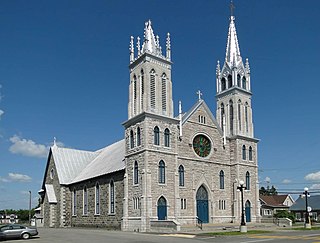
Sainte-Anne-de-la-Pérade is a municipality in the Les Chenaux Regional County Municipality, in the Mauricie region of the province of Quebec in Canada. The town is located near the mouth of the Sainte-Anne River along the Chemin du Roy, a historic segment of Quebec Route 138 that stretches from near Montreal to Quebec City.

<span class="mw-page-title-main">Saint-Adelphe</span> Place in Quebec, Canada

Saint-Adelphe is a Parish municipality of Quebec, Canada, located in the Mékinac Regional County Municipality, in the Batiscanie area and in the administrative region of Mauricie. The territory of the municipality was part of the lordship of Sainte-Anne which was owned by Mr. John Hale, and Mr. Price.

<span class="mw-page-title-main">Saint-Prosper-de-Champlain, Quebec</span> Municipality in Quebec, Canada

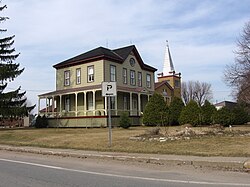
Saint-Prosper-de-Champlain is a municipality of 516 people in the Les Chenaux Regional County Municipality, in Quebec, Canada. It is the smallest municipality in terms of population in the regional county.

<span class="mw-page-title-main">Saint-Stanislas, Mauricie, Quebec</span> Municipality in Quebec, Canada

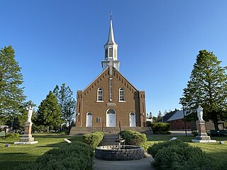
Saint-Stanislas old name Deux-Rivères (Village) is a municipality in Les Chenaux Regional County Municipality in the Mauricie region of the province of Quebec in Canada. It is located along the Batiscan River. The parish is named in honour of St. Stanislaus Kostka to recall the presence of the Jesuits, who were the owners of the lordship of Batiscan.

<span class="mw-page-title-main">Saint-Maurice, Quebec</span> Parish municipality in Quebec, Canada

Saint-Maurice is a parish municipality in the Mauricie region of the province of Quebec in Canada.

<span class="mw-page-title-main">Saint-Narcisse</span> Parish municipality in Quebec, Canada

Saint-Narcisse is a parish municipality located in the regional county municipality (MRC) Chenaux, in the administrative region of Mauricie, in the province of Quebec, in Canada. Located on the North Shore of the Saint Lawrence River, about 30 km (19 mi) from downtown Trois-Rivières, the parish of Saint-Narcisse is the heart of the Mauricie region.

<span class="mw-page-title-main">Sainte-Geneviève-de-Batiscan</span> Parish municipality in Quebec, Canada

Sainte-Geneviève-de-Batiscan is a parish municipality in the Mauricie region of the province of Quebec in Canada. This municipality is part of the Les Chenaux Regional County Municipality in Batiscanie and in the administrative region of Mauricie. It is located along the Batiscan River.

<span class="mw-page-title-main">Batiscan, Quebec</span> Municipality in Quebec, Canada

Batiscan is a municipality in the Mauricie region of the province of Quebec in Canada. It is located along the Saint Lawrence River at the mouth of the Batiscan River.

<span class="mw-page-title-main">Champlain, Quebec</span> Municipality in Quebec, Canada

Champlain is a municipality in the province of Quebec, Canada. It is located in Les Chenaux Regional County Municipality and the administrative region the Mauricie, on the north shore of St. Lawrence River. Champlain is also part of the metropolitan area of Trois-Rivières.

<span class="mw-page-title-main">Lordship of Batiscan</span>

The Lordship of Batiscan was located on, and included 1/2 lieue of frontage along, the north shore of the St. Lawrence River in the province of Quebec, Canada. It was 20 lieues deep. Granted in 1639 to the Jesuits, colonization of the manor began in 1666, after an initial allotments were added to the census in 1665.) The northern boundary of the Lordship was past the source of the Saint-Maurice River. It was the deepest in the seigneurial system of New France. The Lordship of Batiscan became the most populous governed area of the Three Rivers by the end of the 17th Century.

<span class="mw-page-title-main">Champlain River</span> River in Canada

The Champlain River flow on the north shore of St. Lawrence river, between Saint-Maurice River and the Batiscan River watershed, in Les Chenaux Regional County Municipality, in Mauricie administrative region, in the province of Quebec, Canada.

<span class="mw-page-title-main">Charest River</span> River in Quebec, Canada

The Charest River takes its source in Charest Lake, in the sector Montauban-les-Mines, in the extreme East of the municipality of Notre-Dame-de-Montauban, located in the Mekinac Regional County Municipality, in the administrative region of Mauricie in the province of Quebec, Canada. In the upper part, Charest River also drains the surrounding lakes: lake of the Mine, lake Perron, lake Perreault and lake End.

<span class="mw-page-title-main">Rivière-à-la-Lime</span> River

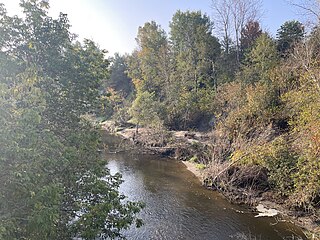
The Rivière à la lime flows in the municipality of Sainte-Geneviève-de-Batiscan, in the Les Chenaux Regional County Municipality, in the administrative region of Mauricie, in the province of Quebec, Canada. The "rivière à la lime" drains a watershed of 25.86 km2. This river has a length of 12.14 km and empties into the Batiscan River.

<span class="mw-page-title-main">Rivière à la Fourche (Champlain River tributary)</span> River in Quebec, Canada

The rivière à la Fourche is a tributary of the northwest bank of the Champlain River, flowing on the east side of the Saint-Maurice River and on the north side of the St. Lawrence River, in the Les Chenaux Regional County Municipality, in the administrative region of Mauricie, in province of Quebec, in Canada.

<span class="mw-page-title-main">Brûlée River (Champlain River tributary)</span> River in Quebec, Canada

The Brûlée River is flowing entirely in the municipality of Saint-Maurice, in the Les Chenaux Regional County Municipality, in the administrative region of Mauricie, in Quebec, Canada.

<span class="mw-page-title-main">Rivière au Lard</span> River in Quebec, Canada

The rivière au Lard flows on 21.2 kilometres (13.2 mi) in the municipality of Notre-Dame-du-Mont-Carmel, then those of Saint-Maurice, Saint-Narcisse and Saint-Luc-de-Vincennes, in the Les Chenaux Regional County Municipality, in the administrative region of Mauricie, in Quebec, in Canada.

References

  1. 1 2 Saint--Luc-de-Vincennes Municipality. "St-Laurent-de-la-Moraine Parish / St-Luc-de-Vincennes Church" (in French). Retrieved 2023-11-11.
  2. 1 2 "Geographic code 37225 in the official Répertoire des municipalités". www.mamh.gouv.qc.ca (in French). Ministère des Affaires municipales et de l'Habitation.
  3. "Saint-Luc-de-Vincennes, Quebec (Code 2437225) Census Profile". 2011 census . Government of Canada - Statistics Canada.
  4. 1 2 "Saint-Luc-de-Vincennes". Commission de toponymie Quebec (in French). Government of Quebec. 1992-04-24. Retrieved 2023-11-09.
  5. Jeremie Perron (2023-11-10). "A dream takes shape in Saint-Luc-de-Vincennes". Le bulletin des Chenaux on line (in French). Retrieved 2023-11-10.
  6. Marilyn Marceau (16 November 2016). "Landslide in Saint-Luc-de-Vincennes". Ici Mauricie—Centre-du-Québec (in French). Radio-Canada. Retrieved 2023-11-09.
  7. 1 2 Tremblay-Auger, Frédérique. "The 2016 landslide at Saint-Luc-de-Vincennes, Quebec: geotechnical and morphological analysis of a combined flowslide and spread". Canadian Geotechnical Journal (in English and French). Canadian science publishing. Retrieved 2023-11-10.
  8. Statistics Canada: 1996, 2001, 2006, 2011 census
  9. Ministère des Transports et de la Mobilité durable (2023-11-10). "Inventory and inspection of structures" (in French). Government of Quebec. Retrieved 2023-11-10.