
Saint-Maurice Castle is a castle in the municipality of Saint-Maurice of the Canton of Valais in Switzerland. It is a Swiss heritage site of national significance. [1]
Saint-Maurice Castle is a castle in the municipality of Saint-Maurice of the Canton of Valais in Switzerland. It is a Swiss heritage site of national significance. [1]
In 1476, Bern began construction of a castle in the narrow Rhone valley at Saint-Maurice. It was completed in 1646 with the expansion of the residential buildings. However, in 1693 a devastating fire in the town, destroyed the warehouse of the castle and much of the gunpowder that was stored there. [2]
Agaunum was an outpost in Roman Switzerland, predecessor of the modern city of Saint-Maurice in the canton of Valais, southwestern Switzerland. It was used by the Roman Empire for the collection of the Quadragesima Galliarum. In Christian tradition, Agaunum is known as the place of martyrdom of the Theban Legion.

Bagnes is a former municipality in the district of Entremont in the canton of Valais in Switzerland. On 1 January 2021 the former municipalities of Bagnes and Vollèges merged to form the new municipality of Val de Bagnes.

The Diocese of Sion is a Latin Catholic ecclesiastical territory in the canton of Valais, Switzerland. It is the oldest bishopric in the country and one of the oldest north of the Alps. The history of the Bishops of Sion, of the Abbey of St. Maurice of Valais as a whole are inextricably intertwined.

Saint-Maurice is a city in the Swiss canton of Valais and the capital of the district of Saint-Maurice. On 1 January 2013, the former municipality of Mex merged into the municipality of Saint-Maurice.
Saint-Gingolph is a small town situated on the south bank of Lake Geneva. It sits at the France–Switzerland border and is administratively divided into Saint-Gingolph, Valais (Switzerland) and Saint-Gingolph, Haute-Savoie (France). Its name is derived from the eighth-century saint Gangulphus, who is said to have lived as a hermit in this region. Its division at the Morge dates from 1569: as the municipal Web site explains, it is one town consisting of a single parish with two municipal administrations and two distinct legal systems.
The district of Saint-Maurice is a district in the canton of Valais in Switzerland. It has a population of 14,102.

Schadau Castle is a castle on the south side of the Aare near Lake Thun in the city of Thun, Canton Bern, Switzerland. It is a Swiss heritage site of national significance.

Landskron Castle is a medieval hill castle northeast of Villach in the state of Carinthia, Austria. Dating to the early 14th century, the castle ruins are located on a rock cone of the Ossiach Tauern range, at an elevation of 658 metres (2,159 ft) above sea level. Today Landskron Castle, its falconry centre conducting regular flying demonstrations, and the nearby macaque enclosure are major tourist destinations.

Fortress Saint-Maurice is one of the three main fortification complexes comprising the Swiss National Redoubt. The westernmost of the three, Fortress Saint-Maurice complements Fortress Saint Gotthard and Fortress Sargans to secure the central alpine region of Switzerland against an invading force. The National Redoubt was first conceived in the 1880s as an easily defensible area to secure the survival of the Swiss Confederation. In the late 1930s and 1940s when neutral Switzerland was threatened with invasion from Germany, the National Redoubt and its components were modernized and expanded on a massive scale. The fortification system was maintained and upgraded during the Cold War. With the collapse of the Soviet Union, the possibility of a Warsaw Pact invasion disappeared, and by 1995 many positions were abandoned by the military.

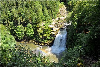
The Grotte aux Fées in the cliffs above Saint-Maurice, Switzerland is a natural limestone solution show cave, featuring a 77-metre (253 ft) high underground waterfall, claimed as the world's highest waterfall in a show cave. The cave was the first show cave in Switzerland. The cave was known until the mid 19th century as the Trou aux Fayes or "Sheep Hole," as it was used as a sheepfold. The cave was known from Roman times, but was first publicized in 1863 as a tourist attraction, with the present name being used from 1865.

The Fort de Dailly is the largest component of Fortress Saint-Maurice, which is in turn one of the three principal fortified regions of the National Redoubt of Switzerland. Almost entirely subterranean, the Fort de Dailly was built in the Massif de Dailly to the east of Saint-Maurice beginning in 1892. With the Fort de Savatan, it comprises a fortress complex encased in rock high above the strategic Saint-Maurice valley, capable of commanding the valley from Chillon to Martigny. It is the central component of Fortress Saint-Maurice in terms of both its position and its military power. Construction began in 1892 and the fort became operational in 1894. The fort was nearly constantly upgraded with new artillery in increasingly secure positions. Following an incident in which three ammunition magazines exploded in close succession in 1946, the fort was repaired and upgraded with two fully automatic 150 mm gun turrets with a range of 24 kilometres (15 mi). After reassessments by the Swiss Armed Forces of their requirements for fixed fortifications, Dailly was progressively closed down starting in 1995, with full closure at the end of 2003.
The Swiss National Redoubt is a defensive plan developed by the Swiss government beginning in the 1880s to respond to foreign invasion. In the opening years of the Second World War the plan was expanded and refined to deal with a potential German invasion. The term "National Redoubt" primarily refers to the fortifications begun in the 1880s that secured the mountainous central part of Switzerland, providing a defended refuge for a retreating Swiss Army.

The Château de Pregny, sometimes referred to as the Rothschild Castle, is a castle in the municipality of Pregny-Chambésy of the Canton of Geneva in Switzerland. It is a Swiss heritage site of national significance.

Belp Castle is a castle in the municipality of Belp in the canton of Bern in Switzerland.

Hünegg Castle is a castle in the municipality of Hilterfingen of the Canton of Bern in Switzerland. It is a Swiss heritage site of national significance.

Laupen Castle is a castle in the municipality of Laupen of the Canton of Bern in Switzerland. It is a Swiss heritage site of national significance.

Gümligen Castle is a castle in the municipality of Muri bei Bern of the Canton of Bern in Switzerland. It is a Swiss heritage site of national significance.

Schwarzenburg Castle is a castle in the municipality of Schwarzenburg of the Canton of Bern in Switzerland. It is a Swiss heritage site of national significance.

The Gümmenenkrieg was a war between the emergent city-states of Bern and Fribourg in 1331-33 in what is now Switzerland. The war pitted Bern and the new Swiss Confederation against the Habsburg-supported city of Fribourg and local nobles. It was also the first in a series of battles that brought the Habsburgs and Fribourg into prominence in the County of Burgundy. The war ended without resolving anything and led to other wars between Bern and Fribourg.
The France–Switzerland border is 572 km (355 mi) long. Its current path is mostly the product of the Congress of Vienna of 1815, with the accession of Geneva, Neuchâtel and Valais to the Swiss Confederation, but it has since been modified in detail, the last time being in 2002. Although most of the border, marked with border stones, is unguarded, several checkpoints remain staffed, most notably on busy roads.
46°13′24″N7°00′11″E / 46.223261°N 7.003109°E
| | This article about a castle in Switzerland is a stub. You can help Wikipedia by expanding it. |