
U.S. Route 340 is a spur route of US 40, and runs from Greenville, Virginia to Frederick, Maryland. In Virginia, it runs north–south, parallel and east of US 11, from US 11 north of Greenville via Waynesboro, Grottoes, Elkton, Luray, Front Royal, and Berryville to the West Virginia state line. A short separate piece crosses northern Loudoun County on its way from West Virginia to Maryland.

Great Eastern Highway is a 590-kilometre-long (370 mi) road that links the Western Australian capital of Perth with the city of Kalgoorlie. A key route for road vehicles accessing the eastern Wheatbelt and the Goldfields, it is the western portion of the main road link between Perth and the eastern states of Australia. The highway forms the majority of National Highway 94, although the alignment through the Perth suburbs of Guildford and Midland, and the eastern section between Coolgardie and Kalgoorlie are not included. Various segments form parts of other road routes, including National Route 1, Alternative National Route 94, and State Route 51.
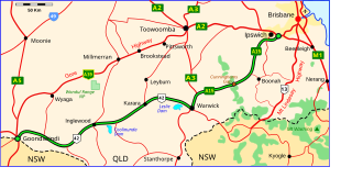
The Cunningham Highway is a 327-kilometre (203 mi) national highway located in south-eastern Queensland, Australia. The highway links the Darling Downs region with the urbanised outskirts of Ipswich via Cunninghams Gap.

Taunggyi is the capital and largest city of Shan State, Myanmar (Burma) and lies on the Thazi-Kyaingtong road at an elevation of 4,712 feet (1,436 m), just north of Shwenyaung and Inle Lake within the Myelat region. Taunggyi is the fifth largest city of Myanmar, and has an estimated population of 380,665 as of 2014. The city is famous for its hot air balloon festival held annually on the full moon day of Tazaungmon.
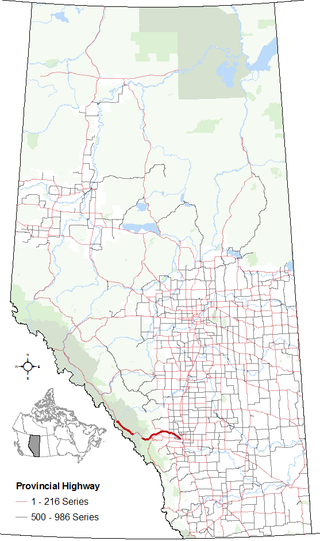
Alberta Provincial Highway No. 1A is the designation of two alternate routes off the Alberta portion of Trans-Canada Highway 1. However, it is not the only name used for spurs off Highway 1 - Highway 1X is another such designation. Despite these highways being suffixed routes of Highway 1, they are not part of the Trans-Canada Highway network, and are signed with Alberta's provincial primary highway shields instead of the Trans-Canada shields used for Highway 1.
Taungtha or Thaungtha is a town in the Mandalay Division of central Myanmar. It located south-west of the volcanic cone Mount Taungtha (1788 ft) and above the right (east) bank of the Sindewa (Sintewa) River.There are six quarters in Taungtha township. Taungtha is the administrative seat for Taungtha Township, and is on both the Taunggyi–Myingyan railway and the Meiktila–Myingyan highway. It is also on the Western Trunk Road from Kyaukpadaung to Natogyi.
Taunggyi Township is a township of Taunggyi District in the Shan State of Myanmar. The principal town is Taunggyi.
Tachileik is a border town in Shan State of eastern Myanmar. It is the administrative seat of Tachileik Township and Tachileik District and most populated city in eastern Shan State with 51,553 residents per 2014 census count, ahead of Kyaing Tong, but only 4th statewide. It faces Mae Sai in Thailand, and is home to one of Myanmar's seven official border trade posts with Thailand.
Hsi Hseng or Hsi-hseng is a town in the Shan State of eastern Burma. It is located in Hsi Hseng Township in Taunggyi District and lies along National Highway 5. It is connected to Loisawn in the north and Tongkaw in the south. The area is a known producer of opium and methamphetamine; poppy fields and a methamphetamine factory have been reported in Hsi Hseng. Gee Dong was killed near Hsi Hseng in 1974.

Nawnghkio, variously spelt Naunghkio, Naungcho or Nawngcho, is a town in Kyaukme District, in northern Shan State, Burma. It is the principal town and administrative seat of Nawnghkio Township. It is connected to Mandalay, Pyin U Lwin, Kyaukme, Hsipaw and Lashio by road and rail and by road to Taunggyi via National Road 43. Asia World Company won the contract to rebuild part of the road in 2002. Originally on the Mandalay-Lashio Road, after Pyin U Lwin and before Kyaukme, Nawnghkio is on what is now the Mandalay-Muse Road, part of the Asian Highway Route 14 (AH14).
Kunlon is a small town in Taunggyi Township, Taunggyi District, Shan State, eastern Burma. It contains a lake and Kunlon Dam. It lies along National Road 43, north of Taunggyi and south of Yedwingyi.
National Highway 5 (NR5) is a highway of southern-central Burma. It connects Taungoo to Hopong, east of Taunggyi.

Sike Khaung or Sai Khao is a village in Hsi Hseng Township, Taunggyi District, Pa'O Self-Administered Zone, in the Shan State of eastern Myanmar. It is located north of the township capital of Hsi Hseng by National Highway 5. Nawnge and Lothkan are located to the west, Loimut to the southeast, and Hsohsa to the northeast.
Nawnge is a village in Hsi Hseng Township, Taunggyi District, in the Shan State of eastern Burma. It is located just west of the town of Loisawn. A road connects it to Lothkan and Nampan on the south shore of Inle Lake in the west.
Lothkan is a village in Taunggyi Township, Taunggyi District, in the Shan State of eastern Burma. It is located west of the town of Loisawn. A road connects it to Nawnge in the east and Nampan on the south shore of Inle Lake in the west.
Tönghsöngkalo is a village in Hsi Hseng Township, Taunggyi District, in the Shan State of eastern Burma. It is located just to the north of the township capital of Hsi Hseng along National Highway 5. It is primarily an agricultural village, with extensive fields located across the road west of the village.
Loisati is a village in Hsi Hseng Township, Taunggyi District, in the Shan State of eastern Burma. It is located just to the north of Tongkaw off the National Highway 5.
Veng-lek is a village in Hsi Hseng Township, Taunggyi District, in the Shan State of eastern Burma. It is located to the south of Tongkaw along the National Highway 5. A river runs to the west of the village from north to south.
Kyawngtet is a village in Hsi Hseng Township, Taunggyi District, in the Shan State of eastern Burma. It is located just to the south of Banyin and to the north of Loisawn along the National Highway 5.
National Road 43 or State Highway 43 is a highway of eastern Burma, passing through Shan State. It connects the National Highway 3 at Nawnghkio at 22°19′41″N96°48′10″E with National Highway 4 at Sakangyi at 20°45′41″N96°56′42″E in the south, several miles west of the city of Taunggyi.
