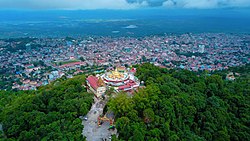
Taunggyi Township

Last updated
Taunggyi Township
Shwe Bone Pwint Pagoda, Taunggyi,Shan.jpg
Myanmar location map.svg
Red pog.svg
Taunggyi Township
Coordinates: 20°47′N97°02′E / 20.783°N 97.033°E / 20.783; 97.033 Coordinates: 20°47′N97°02′E / 20.783°N 97.033°E / 20.783; 97.033
CountryFlag of Myanmar.svg  Burma
State Shan State
District Taunggyi District
Capital Taunggyi
Area
  Total420.9 sq mi (1,090.0 km2)
Population
 (2014)
381,639
Time zone UTC+6:30 (MST)

Taunggyi Township is a township of Taunggyi District in the Shan State of Myanmar. The principal town is Taunggyi.

Contents

Borders

Taunggyi Township is bordered [1] by the following townships:

Formerly, the northern half of Hopong Township was part of Mong Kung Township (Mongkaung Township).

Demographics

2014

Historical Population
YearPop.±%
1973     
1983     
2014 381,639    
Source: Ministry of Labor, Immigration, and Population data

The 2014 Myanmar Census reported that Taunggyi Township had a population of 381,639. [2] The population density was 350.1 people per km². [2] The census reported that the median age was 26.2 years, and 95 males per 100 females. [2] There were 82,604 households; the mean household size was 4.3. [2]

Towns

Communities

In addition to the town of Taunggyi itself, there are two large towns in Taunggyi Township: Ayetharyar and Kyauktalonegyi. Among the many villages and wards (village census tracts) in Taunggyi Township are:

Notes

  1. "Myanmar States/Divisions & Townships Overview Map" Myanmar Information Management Unit (MIMU)
  2. 1 2 3 4 "Taunggyi Township Report" (PDF). 2014 Myanmar Population and Housing Census. October 2017.
  3. "Hang Si Map — Satellite Images of Hang Si" Maplandia
  4. "Htedaung Map — Satellite Images of Htedaung" Maplandia
  5. "Kanpaw Tang-tok Map — Satellite Images of Kanpaw Tang-tok" Maplandia
  6. "Kon-kawng Map — Satellite Images of Kon-kawng" Maplandia
  7. "Lothkan Map — Satellite Images of Lothkan" Maplandia
  8. "Mai Tang Hsong Map — Satellite Images of Mai Tang Hsong" Maplandia
  9. "Man Kong Map — Satellite Images of Man Kong" Maplandia
  10. "Nyawngkon Map — Satellite Images of Nyawngkon" Maplandia
  11. "Sakangyi Map — Satellite Images of Sakangyi" Maplandia
  12. "Shwenyaung Map — Satellite Images of Shwenyaung" Maplandia
  13. "Wan Mansaw Map — Satellite Images of Wan Mansaw" Maplandia


Related Research Articles

Shan State State of Myanmar

Shan State is a state of Myanmar. Shan State borders China (Yunnan) to the north, Laos to the east, and Thailand to the south, and five administrative divisions of Burma in the west. The largest of the 14 administrative divisions by land area, Shan State covers 155,800 km2, almost a quarter of the total area of Burma. The state gets its name from Burmese name for the Tai people: "Shan people". The Shan constitute the majority among several ethnic groups that inhabit the area. Shan is largely rural, with only three cities of significant size: Lashio, Kengtung, and the capital, Taunggyi. Taunggyi is 150.7 km northeast of the nation's capital Naypyitaw.

Heho Town in Shan State, Burma

Heho is a small town in Kalaw Township, Taunggyi District, Shan State of Myanmar. It is the primary air gateway to tourist areas such as Inle Lake.

Lumbang (Lumbana) is a village in Falam Township, Falam District Chin State, Myanmar, 9.4 kilometres (5.8 mi) north of the town of Falam on the Tedim Road. Lumbang observes Myanmar Time with a UTC offset of 6.5 hours.

Yamethin Township Township in Mandalay Region, Burma

Yamethin Township is a township of Yamethin District in the Mandalay Region of Burma (Myanmar). The administrative seat and principal city is Yamethin, which is also the major rail stop in the township.

Pathein Township Township in Ayeyawady Division, Burma

Pathein Township is a township of Pathein District in the Ayeyawady Division of Burma (Myanmar). The administrative seat is the town of Pathein.

Mindat Township Township in Chin State, Myanmar

Mindat Township is a township located in Mindat District in the Chin State of Myanmar. The township is located between latitude 21.19 and 21.47, longitude 93.23 and 94.29. The third highest peak in Myanmar, Nat Ma Taung at 3,053 metres (10,016 ft), is visible from here, though it is within Kanpetlet township boundary. Mindat was a part of Pakokku Hill Tracts District.

Kyain Seikgyi Township Township in Kayin State, Burma

Kyainseikgyi Township is a township of Kawkareik District in the Kayin State of Myanmar. It is the fourth-biggest township in Kayin State. The two main sub-towns are Kyeikdon and Payathonsu. It is drained by the Zami, Winyaw and the Haungtharaw rivers.

Myebon Township Township in Rakhine State, Burma

Myebon Township is a township of Mrauk-U District in the Rakhine State of Burma (Myanmar). The principal town is Myebon. In October 2010, much of the township was devastated by Cyclone Giri. Some villages were completely destroyed by the storm and thousands of people were left homeless.

Nyaungshwe Township Township in Shan State, Myanmar

Nyaungshwe Township is a township of Taunggyi District in Shan State, Myanmar. It is located south of Sakangyi and south-west of Taunggyi. The principal town is Nyaungshwe.

Hsi Hseng Township Township in Shan State, Burma

Hsi Hseng Township is a township of Taunggyi District in the Shan State of Myanmar. The principal town is Hsi Hseng.

Kyaukme Township Township in Shan State, Burma

Kyaukme Township is a township of Kyaukme District in the Shan State of eastern Burma (Myanmar). The principal town and administrative center is Kyaukme. The only other town is Mongngaw (Mongngawt) located in the northeast corner of the township.

Mong Khet Township Township in Shan State, Burma

Mong Khet Township is a township of Kengtong District in the Shan State of Burma. The principal town and administrative center is Mong Khet. It has been calculated to be the center of the Valeriepieris circle.

Mong Kung Township Township in Shan State, Burma

Mong Kung Township or Mongkaung Township is a township of Loilen District in the Shan State of Burma. The principal town is Mong Kung.

Hopong Town in Shan State, Myanmar

Hopong is a town in the Shan State of eastern Burma. It is located in Hopong Township in Taunggyi District. Hopong has many famous places, like Htam Sam Cave and Mway Taw Pagoda. Many visitors from different parts of the country enjoy going to Htam Sam Cave, which is not only a beauty spot for nature lovers, but also a place with numerous Buddha images which attract many Buddhist pilgrimages. Near the cave, moreover, free delicious vegetarian meal is served which is well worth enjoying. Mway Taw Pagoda is an impressive pagoda in the centre of the town which is the most significant religious site in Hopong.

Kalewa Township Township in Sagaing Region, Burma

Kalewa Township is a township of Kale District in Sagaing Division of Burma (Myanmar). The principal town and administrative seat is Kalewa. The Paluzawa coal mines are located in Kalewa township.

Thayet Township Township in Magway, Burma

Thayet Township is a township of Thayet District in the Magway Region of Burma (Myanmar). It lies on the west side of the Irrawaddy. The major town and administrative center is Thayet. Notable peaks are Mount Myinba (1688 ft.) and Mount Myinmagyi (1032 ft.).

Bago Township or Pegu Township is a township in Bago District in the Bago Region of Burma. The principal town is Bago.

Nawnge Village in Shan State, Burma

Nawnge is a village in Hsi Hseng Township, Taunggyi District, in the Shan State of eastern Burma. It is located just west of the town of Loisawn. A road connects it to Lothkan and Nampan on the south shore of Inle Lake in the west.

Lothkan Village in Shan State, Burma

Lothkan is a village in Taunggyi Township, Taunggyi District, in the Shan State of eastern Burma. It is located west of the town of Loisawn. A road connects it to Nawnge in the east and Nampan on the south shore of Inle Lake in the west.

Sakangyi, Taunggyi Town in Shan State, Burma

Sakangyi is a town in Taunggyi Township in Taunggyi District in the Shan State of eastern Burma. It is located west along National Highway 4 from Aye Thar Yar and Taunggyi. The National Road 43 begins in the eastern part of the town and connects National Highway 4 to National Highway 3 in the north at Nawnghkio. It is connected via National Highway 4 to Heho in the west.