This article needs additional citations for verification .(May 2021) |
Mong Hsat မိုင်းဆတ်မြို့နယ် | |
---|---|
Coordinates: 20°32′00″N99°15′00″E / 20.53333°N 99.25000°E | |
Country | Myanmar |
State | Shan |
District | Mong Hsat District |
Elevation | 598 m (1,962 ft) |
Time zone | UTC+6.30 (MST) |
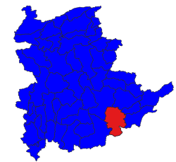
Mong Hsat Township is a township of Mong Hsat District in the Shan State of Myanmar. The capital town is Mong Hsat.
Shan State is a state of Myanmar. Shan State borders China (Yunnan) to the north, Laos to the east, and Thailand to the south, and five administrative divisions of Burma (Myanmar) in the west. The largest of the 14 administrative divisions by land area, Shan State covers 155,800 km2, almost a quarter of the total area of Myanmar. The state gets its name from Burmese name for the Tai peoples: "Shan people". The Tai (Shan) constitute the majority among several ethnic groups that inhabit the area. Shanland is largely rural, with only three cities of significant size: Lashio, Kengtung, and the capital, Taunggyi. Taunggyi is 150.7 km northeast of the nation's capital Naypyitaw.
Mong Pan or ဝဵင်းမိူင်းပၼ်ႇ is a town and seat of Mong Pan Township in the southern Shan State of Burma. To the south it borders Mae Hong Son Province in Thailand and lies west of the Salween River. It lies along National Road 45.
Mong Ton also known historically as Möngtung and Maington, is a town and seat of Mong Ton Township in Mong Hsat District, Shan State in eastern Myanmar near the border with Thailand. Mong is equivalent to [Township or land]."Ton"is equivalent to [Royal City]. It is located in the Daen Lao Range, in the eastern part of the Shan State, east of the Salween River. Mong Ton lies on the National Highway 22 and connected to NarkgMuu and Ponparkyin, is also connected to Mong Hsat by National Highway 49 which begins to the north-east of the town.
Mong Hsat is a town in the Shan State of Myanmar, the capital of Mong Hsat Township. It is served by Monghsat Airport.
Monghsat Airport is an airport in Monghsat, Myanmar. On average, it has 1 departure flight each day.
The Shan State Army – South, also known simply as the Shan State Army, is the armed wing of the Restoration Council of Shan State (RCSS) and one of the largest insurgent groups in Myanmar (Burma). The SSA-S was led by Lieutenant General Yawd Serk until his resignation on 3 February 2014. Yawd Serk was reelected chairman of the RCSS shortly after his resignation and has remained chairman since.
Mong Pan Township is a township of Langkho District in the Shan State of Myanmar. The capital town is Mong Pan or Möngpan, formerly the residence of the Sawbwa.
Mong Ton Township is a Township in the Eastern Shan State of Myanmar. The capital town is Mong Ton. It borders are Mong Pying Township to the north, Mong Hsat Township to the east, Mong Nai Township and Mong Pan Township to the west and Thailand to the south. Loi Hkilek mountain is located in the area. It has two towns. They are Ponparkyin and Mong Hta. At Mong Ton township, live in Shan, Lahu, Lisu, Wa, Burma, and Chinese.
Mong Ping Township is a township of Kengtung District in the Shan State of Myanmar. The capital town is Mong Ping.
Kengtung Township is a township of Kengtung District in the Shan State of Myanmar. The principal town is Kengtung. It lies almost entirely east of the Salween River and its area is over 12,000 square miles (31,000 km2). It is bounded on the north by the states of Mang Lon, Mong Lem and Keng Hung ; east by the Mekong River, south by the Siamese Shan States, and west in a general way by the Salween River, though it overlaps it in some places. The state is known to the Chinese as Mhng Khng, and was frequently called by the Burmese the 32 cities of the Gn (HkOn). The classical name of the state is Khemarata or Khemarata Tungkapuri.
Kengtung District is a district of the Shan State in Myanmar. It consists of three towns and 1449 villages.
Mong Hsat District is a district of Shan State in Myanmar. It consists of 2 townships 5 towns and 1095 villages.
Loilem District is a district of the Shan State in Myanmar. It consists of 9 towns in 2010. Its capital is Loilem.
Wan Hsa-la is a village in Mong Ton Township in Mong Hsat District, Shan State. It lies near the Salween River and is surrounded by forests, connected by road across the hills to Mong Ton and Thailand in the east. The village was the site of a battle in 1948 between the Burmese army together with the Chinese Communist troops dressed in Burmese army uniforms against the KMT, commanded by General Li. The village is connected by National Highway Rd 22 (Myanmar) to Mong Ton in the east and after a bridge across the Salween south of the village the road eventually joins National Highway 22(Myanmar) at Nansang.
The Burmese–Siamese War of 1849–1855 or Siamese Invasions of Kengtung or Kengtung Wars were military expeditions of the Siamese Rattanakosin Kingdom against the Tai Khün State of Kengtung, which had been under Burmese suzerainty under the Konbaung dynasty. The dynastic struggles in Tai Lue State of Chiang Hung or Sipsongpanna prompted Siam, in cooperation with the Kingdom of Lanna, to invade Kengtung in order to gain access to Chiang Hung. In the First Invasion in 1850, the Siamese court had ordered the Lanna Lord of Chiang Mai to organize the offensives against Kengtung. Lanna troops failed to conquer Kengtung. Two other expeditions occurred in 1852 and 1853 as Bangkok commanded its troops to directly participate in the invasions. Both expeditions also failed because of internal issues and geographical unfamiliarity. The State of Kengtung under the leadership of Saopha Maha Hkanan, with limited assistance from Burma who had been embroiling in the Second Anglo-Burmese War, managed to resist Siamese-Lanna invasions three times.
The Kuomintang in Burma or Kuomintang in the Golden Triangle were Kuomintang troops that fled from China to Burma in 1950 after their defeat by the Chinese communists in the Chinese Civil War. They were commanded by General Li Mi. It attempted several incursions into Yunnan in the early 1950s, only to be pushed back into Burma each time by the Chinese Communist Party's People's Liberation Army.
Möng Kyawt, also known as Mongkyawt is a village in Hway Aww Village Tract, Ponparkyin and Mong Ton Township of Mong Hsat District, Shan State, eastern Myanmar.
Monghsat or Mönghsat was small state of the Shan States in what is today Burma.
Kawila, also known as Phra Boromrachathibodi, was the Northern Thai ruler of the Chiangmai Kingdom and the founder of the Chetton dynasty. Originating from Lampang, Kawila arose to become the ruler of Chiangmai appointed by King Rama I as a tributary ruler. Kawila had a great role in the transfer of Lanna from Burmese rule to Siamese domination and the rebuilding of Chiangmai as the center of Lanna.
Burmese-Siamese War (1802–1805) was the military conflict between the Kingdom of Burma under the Konbaung dynasty and Kingdom of Siam under the Chakri dynasty over the Lan Na city-states. It is composed of two parts: the Burmese Invasion of Chiang Mai in 1802 and the Siamese Invasion of Chiang Saen in 1804. The Burmese King Bodawpaya attempted to reclaim the lost dominions in Lan Na, east of Salween River. Lan Na, under leadership of Prince Kawila of Chiang Mai with Siamese support, successfully repelled the Burmese invasion. The Siamese under King Rama I then dispatched troops, in retaliation, to attack Burmese Chiang Saen in 1805. The town of Chiang Saen surrendered and came under Siamese rule. The wars resulted in the permanent eradication of Burmese influence from Lan Na.