
Myanmar is the northwesternmost country of mainland Southeast Asia. It lies along the Indian and Eurasian Plates, to the southeast of the Himalayas. To its west is the Bay of Bengal and to its south is the Andaman Sea. It is strategically located near major Indian Ocean shipping lanes. The neighboring countries are China, India, Bangladesh, Thailand and Laos.

The Salween is a Southeast Asian river, about 3,289 kilometres (2,044 mi) long, flowing from the Tibetan Plateau south into the Andaman Sea. The Salween flows primarily within southwest China and eastern Burma (Myanmar), with a short section forming the border of Burma and Thailand. Throughout most of its course, it runs swiftly through rugged mountain canyons. Despite the river's great length, only the last 90 km (56 mi) are navigable, where it forms a modest estuary and delta at Mawlamyine. The river is known by various names along its course, including Thanlwin in Burma and Nu River in China. The commonly used spelling "Salween" is an anglicisation of the Burmese name dating from 19th-century British maps.

Mae Hong Son Province, also spelled Maehongson, Mae Hong Sorn or Maehongsorn, is one of Thailand's seventy-six provinces (changwat) lies in upper northern Thailand and is the westernmost province. Neighboring provinces are Shan State of Myanmar, Chiang Mai and Tak. To the west, the province borders Kayin State and Kayah State of Myanmar. Mae Hong Son's nickname is "the city of three mists". It is hemmed in by the high mountain ranges of the Shan Hills and is the most mountainous province in Thailand, occupying 12,681 square kilometres (4,896 sq mi). The province is often covered with mist. Mae Hong Son town was originally established in the early 19th century as an elephant training camp as ordered by the then King of Chiang Mai. As of 2012 Mae Hong Son was the poorest province in Thailand.

Northern Thailand is geographically characterised by several mountain ranges, which continue from the Shan Hills in bordering Myanmar to Laos, and the river valleys which cut through them. Though like most of Thailand, it has a tropical savanna climate, its relatively high elevation and latitude contribute to more pronounced seasonal temperature variation, with cooler winters than the other regions. Historically it is related to the Lanna Kingdom and its culture.

Theinni or Hsenwi is a town in northern Shan State of Burma, situated near the north bank of the Nam Tu River and now the centre of Hsenwi Township in Lashio District. It is 28 miles (45 km) north of Lashio. It is 2,100 feet (640 m) above sea level.

Mang Lon, Manglon, Manglun, Manglön, or Mang Lön a state in the northern Shan states of Myanmar, was formerly the chief state of the Wa people. It is a mountainous territory, including the valleys of the Salween and its tributary the Nam Hka. It had an approximate area of 7770 km² and its estimated population in 1911 was 40,000.

Kunlong is the capital town of Kunlong Township in Shan State. its coordination is 23 25' 00" N and 98 39' 00" E.
Laihka State was a state in the central division of the Southern Shan States of Burma, with an area of 3711 km².
Mong Pan Township is a township of Loilen District in the Shan State of Myanmar. The capital town is Mong Pan or Möngpan, formerly the residence of the Sawbwa.
Kengtung Township is a township of Kengtung District in the Shan State of Myanmar. The principal town is Kengtung. It lies almost entirely east of the Salween River and its area is over 12,000 square miles (31,000 km2). It is bounded on the north by the states of Mang Lon, Mong Lem and Keng Hung ; east by the Mekong River, south by the Siamese Shan States, and west in a general way by the Salween River, though it overlaps it in some places. The state is known to the Chinese as Mhng Khng, and was frequently called by the Burmese the 32 cities of the Gn (HkOn). The classical name of the state is Khemarata or Khemarata Tungkapuri.

The Shan Hills, also known as Shan Highland, is a vast mountainous zone that extends through Yunnan to Myanmar and Thailand. The whole region is made up of numerous mountain ranges separated mostly by narrow valleys as well as a few broader intermontane basins. The ranges in the area are aligned in such a way that they link to the foothills of the Himalayas further to the northwest.
Teng River or Nam Teng is a river of Shan State, eastern Burma. It is a tributary of the Salween River.

Kantarawadi, also known as Gantarawadi, was one of the Karenni States in what is today Kayah State in Burma. It was also known as "Eastern Karenni" owing to the location of part of its territory east of the Salween River.

Hopang is the capital of Hopang Township, Shan State, Myanmar (Burma). It is also the government designated capital of the Wa Self-Administered Division.
The Nam Pang River, also known as Pang River, is a major river of Shan State, eastern Burma. It is the largest tributary of the Salween River.

The Daen Lao Range is a mountain range of the Shan Hills in eastern Burma and northern Thailand. Most of the range is in Shan State, with its northern limit close to the border with China, and runs southwards across the Thai border, at the northern end of Thailand.
Nā-hki-lek or Na-hkilek is a river village on the Salween River in Shan State of eastern Burma. It lies on the confluence of the Salween and the Nam Pang River. A few miles north beyond the junction is said to be "a strange whirlpool, at the place the river is in a gorge between limestone cliffs, which fall smooth and precipitous to the water's edge."

The Federated Shan States was an administrative division of the British Empire made up by the much larger Shan States and the Karenni States during British rule in Burma.
Hka River or Nam Hka is a river of Shan State, Burma. It is a left hand tributary of the Salween.
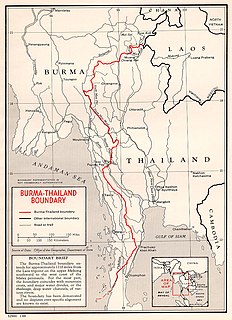
The Myanmar–Thailand border is the international border between the territory of Myanmar and Thailand. The border is 2,416 km in length and runs from the tripoint with Laos in the north to Andaman Sea coast in the south.


