This is a list of aviation-related events from 1989.
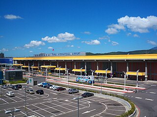
Taipei Songshan Airport is a city airport and military airbase located in Songshan District, Taipei, Taiwan. The airport covers an area of 182 hectares.

Shan State is a state of Myanmar. Shan State borders China (Yunnan) to the north, Laos to the east, and Thailand to the south, and five administrative divisions of Myanmar in the west. The largest of the 14 administrative divisions by land area, Shan State covers 155,800 km2, almost a quarter of the total area of Myanmar. The state gets its name from the Burmese name for the Tai peoples: "Shan people". The Tai (Shan) constitute the majority among several ethnic groups that inhabit the area. Shanland is largely rural, with only three cities of significant size: Lashio, Kengtung, and the capital, Taunggyi. Taunggyi is 150.7 km northeast of the nation's capital Naypyitaw.

Khun Sa was an ethnic Han drug lord and warlord. He was born in Hpa Hpeung village, in the Loi Maw ward of Mongyai, Northern Shan State, Burma. Before he assumed the Shan name "Khun Sa" in 1976, he was known primarily by his Chinese name, Zhang Qifu (張奇夫).

Taunggyi is the capital and largest city of Shan State, Myanmar (Burma) and lies on the Thazi-Kyaingtong road at an elevation of 4,712 feet (1,436 m), just north of Shwenyaung and Inle Lake within the Myelat region. Taunggyi is the fifth largest city of Myanmar, although Taunggyi is the capital of Shan State,45% of population are Pa'O people, and has an estimated population of 380,665 as of 2014. The city is famous for its hot air balloon festival held annually on the full moon day of Tazaungmon.

Air Bagan Limited was an airline headquartered in Bahan Township, Yangon, Myanmar. It operated domestic scheduled services within Myanmar, as well as to Thailand. Its main bases were Yangon International Airport and Mandalay International Airport.

Petrozavodsk Airport is a joint civil-military airport in Russia located 12 kilometres (7.5 mi) northwest of Petrozavodsk in Besovets, Shuya Rural Settlement (municipality). It services small airliners. It is a minor airfield with 12 parking stands and a small amount of tarmac space.

The Myanmar Air Force is the aerial branch of the Tatmadaw, the armed forces of Myanmar. The primary mission of the Myanmar Air Force (MAF) since its inception has been to provide transport, logistical, and close air support to the Myanmar Army in counter-insurgency operations. It is mainly used in internal conflicts in Myanmar, and, on a smaller scale, in relief missions, especially after the deadly Cyclone Nargis of May 2008.
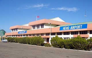
Heho Airport is an airport serving Heho, a town in Kalaw Township, Taunggyi District, Shan State, Myanmar. It is the main airport serving Inle Lake and Taunggyi the former of the top tourist destinations of Myanmar.
Myanmar National Airlines, formerly Union of Burma Airways, Burma Airways, and Myanma Airways, is a state-owned airline and the flag carrier of Myanmar, based in Yangon. Founded in 1948, the airline operates scheduled services to all major domestic destinations and to regional destinations in Asia. Its main base is Yangon International Airport.
Aungban is a major trading town in the southern Shan State of Myanmar that supplies agricultural yield to the rest of the country. It is located in Kalaw Township which is part of Taunggyi District. It lies on the Thazi-Kyaingtong road at an elevation of 4,219 feet (1,286 m) above sea level.
Nansang or Namsang is a town in Namsang District of Shan State in eastern Myanmar. It is the seat of Nansang Township. It is the biggest settlement of the eastern central area of the Shan State in Myanmar with 26,060 people in 2019. Most residents live in Ward 4, the northwest part of the town. It is 72 miles away from Taunggyi. A pagoda lies in the southern part of the town. It is also known as Taung Paw Pagoda.
Taunggyi Township is a township of Taunggyi District in the Shan State of Myanmar. The principal town is Taunggyi.

Nyaungshwe Township is a township of Taunggyi District in Shan State, Myanmar. It is located south of Sakangyi and south-west of Taunggyi. The principal town is Nyaungshwe.
Tachileik is a border town in Shan State of eastern Myanmar. It is the administrative seat of Tachileik Township and Tachileik District and most populated city in eastern Shan State with 51,553 residents per 2014 census count, ahead of Kyaing Tong, but only 4th statewide. It faces Mae Sai in Thailand, and is home to one of Myanmar's seven official border trade posts with Thailand.
Hsi Hseng or Hsi-hseng is a town in the Shan State of eastern Burma. It is located in Hsi Hseng Township in Taunggyi District and lies along National Highway 5. It is connected to Loikaw in the South and Taunggyi in the south. The area is a known producer of opium and methamphetamine; poppy fields and a methamphetamine factory have been reported in Hsi Hseng. Gee Dong was killed near Hsi Hseng in 1974. People there are mostly Pa-Oh and some are Shan but Burmese are increasing now on 2023.
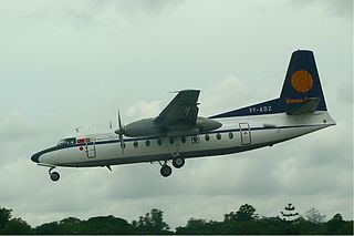
Myanma Airways Flight 635 was a scheduled domestic passenger flight from Yangon to Tachileik in eastern Myanmar that was operated by a Fokker F-27 Friendship owned by Myanmar's flag carrier Myanma Airways. On 24 August 1998, during its descent to Tachileik the flight went missing over a hill approximately two miles (3.2 km) from the airport. Search and rescue team later found the wreckage of the aircraft. The accident killed all 36 passengers and crew.
Sakangyi is a town in Taunggyi Township in Taunggyi District in the Shan State of eastern Burma. It is located west along National Highway 4 from Aye Thar Yar and Taunggyi. The National Road 43 begins in the eastern part of the town and connects National Highway 4 to National Highway 3 in the north at Nawnghkio. It is connected via National Highway 4 to Heho in the west.

Air Bagan Flight 011 was a scheduled domestic passenger flight of a Fokker 100 twinjet from Yangon to Heho, Myanmar. On 25 December 2012, the aircraft crash-landed short of the runway at Heho Airport in fog, coming to a stop in a paddy field and bursting into flames. One of the 71 people on board and a motorcyclist on the ground were killed and more than 10 people were injured.
On 11 October 1987, a Fokker F27 operated by Burma Airways crashed while en route to Pagan from Rangoon, Burma. The regularly scheduled domestic flight was carrying 49 passengers and crew. The aircraft struck a hillside south of Nyaung U Airport, killing everyone on board. It was the second fatal crash involving Burma Airways in four months.

