Just like in the bordering quarters, streets and squares of Salario are mostly named after Italian cities (south of Villa Albani) and rivers (in the northern area). Odonyms of the quartiere can be categorized as follows:
"The gardens of the Villa Albani" by Edward Lear, 1840.
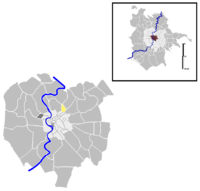
Salario is among the first 15 quartieri born in 1911 and officially established in 1921. In 1926 it was reduced following the establishment of the Quarter Q. XVII Savoia (currently Trieste).
The territory immediately outside Porta Pia remained a rural area until the end of the 19th century, like all the areas outside the Aurelian walls then known as "suburbia".
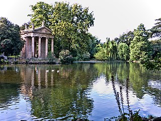
The area, crossed by Via Nomentana and Via Salaria, which originate from there, hosted hunting lodges and country residences since the 18th century, such as Villa Albani – still existing today and whose park occupies a good quarter of the territory – and Villa Patrizi (in the quarter Nomentano). The latter stood immediately outside Porta Pia and was sacrificed to the needs of urban expansion of Rome after the unification of Italy. The site is now occupied by the Ministry of Transport.
The first building activities on the new allotments outside the Aurelian walls began outside Porta Pia and Porta Salaria as early as the last two decades of the 19th century. However, it was only in 1911 that the city administration sanctioned the birth of the new quarters, making them official in 1921. The area of the quarter Salario was included within the territory defined by Porta Pia and Porta Salaria up to the bridge over the Aniene and the left bank of the same river.
This territorial delimitation was then revised in 1926 with the establishment of the quarter Savoia (the current quarter Trieste), which included all the areas beyond the current Viale Regina Margherita, thus reducing in a relevant way the area of the quarter Salario.
Giorgio Carpaneto; others (1997). I quartieri di Roma. Rome: Newton Compton Editori.
Giorgio Carpaneto (1991). "QUARTIERE IV. SALARIO". I Rioni e i Quartieri di Roma. 6. Rome: Newton Compton Editori.
Carlo Pietrangeli (1953). "Insegne e stemmi dei rioni di Roma"(PDF). Capitolium. Rassegna di attività municipali. Rome: Tumminelli – Istituto Romano di Arti Grafiche. year XXVIII (6).
Claudio Rendina; Donatella Paradisi (2004). Le strade di Roma. 1. Rome: Newton Compton Editori.
Claudio Rendina (2006). I quartieri di Roma. 1. Rome: Newton Compton Editori.
Trastevere is the 13th rione of Rome: it is identified by the initials R. XIII and it is located within the Municipio I. Its name comes from the Latin trans Tiberim, meaning literally "beyond the Tiber".
The Aurelian Walls are a line of city walls built between 271 AD and 275 AD in Rome, Italy, during the reign of the Roman Emperors Aurelian and Probus. They superseded the earlier Servian Wall built during the 4th century BC.
The city of Rome, Italy is divided into first-level administrative subdivisions.
Esquilino is the 15th rione of Rome, identified by the initials R. XV, and is Located within the Municipio I. It is named after the Esquiline Hill, one of the Seven Hills of Rome.
Ludovisi is the 16th rione of Rome (Italy), identified by the initials R. XVI and located within the Municipio I.
Sallustiano is the 17th rione of Rome, identified by the initials R. XVII. It is located within the Municipio I and the name refers to the ancient Gardens of Sallust, which were located here.
Castro Pretorio is the 18th rione of Rome (Italy), identified by the initials R. XVIII, and it is located within the Municipio I. The rione takes its name by the ruins of the Castrum Praetorium, the barracks of the Praetorian Guard, included in the Aurelian Walls.
Campo Marzio is the 4th rione of Rome, identified by the initials R. IV. It belongs to the Municipio I and covers a smaller section of the area of the ancient Campus Martius. The logo of this rione is a silver crescent on a blue background.
Parioli is the 2nd quartiere of Rome, identified by the initials Q. II.
Monte Sacro is the 16th quartiere of the city of Rome in Italy. As a quarter, or second level administrative division, it is one of two that comprise the first level division of Municipio III.
Castro Pretorio is a station on Line B of the Rome Metro. It was opened on 8 December 1990 and is located on Viale Castro Pretorio, at its junction with Via San Martino della Battaglia, in the Castro Pretorio rione. Its exit overlooks the Castra Praetoria, now the site of the Biblioteca Nazionale Centrale.
The Porta Nomentana was one of the gates in the Aurelian Walls of Rome, Italy. It is located along viale del Policlinico, around 70 m east of Porta Pia. It is now blocked and merely a boundary wall for the British Embassy.
Ostiense is the 10th quartiere of Rome, identified by the initials Q. X.
Val Melaina is the 1st zona of Rome, identified by the initials Z. I, lying north of the city centre and covering an area of 6.2447 km ².
Portuense is the 11th quartiere of Rome (Italy), identified by the initials Q.XI.
Municipio Roma III is the third administrative subdivision of Rome (Italy).
Flaminio is the 1st quartiere of the Italian capital Rome. Identified by the initials Q. I, it belongs to the Municipio II and has 13,018 inhabitants and an area of 1.1877 km². The name is derived from the Via Flaminia.
Pinciano is the 3rd quartiere of Rome (Italy), identified by the initials Q. III. The name derives from the Pincian Hill. It belongs to the Municipio II.
Trieste is the 17th quarter of Rome (Italy), identified by the initials Q. XVII.
Castel Giubileo is the second Zone of Rome in the Ager Romanus, identified as Z. II.
This page is based on this Wikipedia article Text is available under the CC BY-SA 4.0 license; additional terms may apply. Images, videos and audio are available under their respective licenses.