
Eliseyna Cove is a 3 km wide cove indenting for 1.4 km in the northwest coast of Varna Peninsula between Slab Point to the north and Kotis Point to the south. The cove is named after the Iskar Gorge settlement of Eliseyna in western Bulgaria.

Pastra Glacier is a 4.8 km long and 2 km wide glacier in the central part of Trinity Island in the Palmer Archipelago, Antarctica. Draining northwards to flow into Milburn Bay.
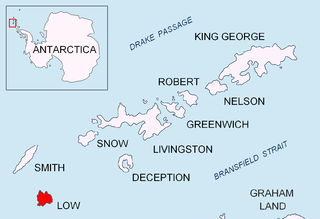
Kazichene Cove is a 2.2 km wide cove on the southeast side of Osmar Strait indenting for 1.3 km the northwest coast of Low Island in the South Shetland Islands, Antarctica. Entered between Fernandez Point and Solnik Point.
Belimel Bay is a 5.9 km wide bay indenting for 3.9 km the southwest coast of Trinity Island in the Palmer Archipelago, Antarctica. Entered between Asencio Point and Spert Island.
Krivina Bay is a 5 km wide bay indenting for 3 km the west coast of Trinity Island in the Palmer Archipelago, Antarctica. Entered north of Romero Point. The three rocky islands of Imelin, Dink and Rogulyat lye in the north part of the bay.
Bebresh Point is a point projecting 1.3 km from the northwest coast of Liège Island in the Palmer Archipelago, Antarctica forming the north side of the entrance to Palakariya Cove and the west side of the entrance to Boisguehenneuc Bay. Situated 7.7 km southwest of Moureaux Point and 11.3 km north-northeast of Chauveau Point.

Galata Cove is the 1.93 km wide cove indenting for 2.18 km the northeast coast of Anvers Island in the Palmer Archipelago, Antarctica. It is entered south of Frolosh Point and north of Deliradev Point.

Yatrus Promontory is the predominantly ice-free promontory projecting 8 km in east direction from Trinity Peninsula, Graham Land into Prince Gustav Channel south of Eyrie Bay, and ending in Jade Point to the east and Bald Head to the southeast.

Klimash Passage is the 1.9 km wide passage in the South Shetland Islands between Table Island and Bowler Rocks on the northwest and Morris Rock and Chaos Reef, Aitcho Islands to the SE. The area was visited by early 19th century sealers.
Preker Point is the sharp rocky point forming the north side of the entrance to Saldobisa Cove on the west coast of Trinity Island in the Palmer Archipelago, Antarctica.
Burya Point is the rocky south entrance point of Saldobisa Cove and north entrance point of Olusha Cove, formed by an offshoot of Ketripor Hill on the northwest coast of Trinity Island in the Palmer Archipelago, Antarctica.
Beripara Cove is the 2.45 km wide cove indenting for 1.8 km the southeast coast of Liège Island in the Palmer Archipelago, Antarctica. It is entered north of Balija Point and south of Leshko Point.

Karasura Glacier is the 4 nautical miles long and 1.4 nautical miles wide glacier on the northeast side of Bastien Range in Ellsworth Mountains, Antarctica. It drains the north slopes of Bergison Peak and the east slopes of Patmos Peak, flows northwards, leaves the range and enters the southeast flowing Nimitz Glacier.

Trepetlika Glacier (Bulgarian: ледник Трепетлика, ‘Lednik Trepetlika’ \'led-nik tre-pe-'tli-ka\ is the 8 km long and 3.5 km wide glacier on the south side of Sonketa Ridge in the west foothills of Detroit Plateau on Danco Coast in Graham Land, Antarctica. It drains the northwest slopes of Razhana Buttress, flows westwards and enters Brialmont Cove north of the terminus of Mouillard Glacier.

Vinitsa Cove is the 3.75 km wide cove indenting for 1.9 km Davis Coast in Graham Land, Antarctica east of Cape Page and west of Havilland Point. The cove is named after the settlement of Vinitsa in Southern Bulgaria.
Tizoin Point is the rocky point on the southwest coast of Trinity Island in the Palmer Archipelago, Antarctica projecting 1 km southwestwards into Belimel Bay. It is “named after Tizoin Cave in Western Bulgaria.”
Olusha Cove is the 2.7 km wide cove indenting for 1 km the northwest coast of Trinity Island in the Palmer Archipelago, Antarctica. It is entered north of Consecuencia Point and south of Burya Point, and is surmounted by Ketripor Hill and Tower Hill on the east.
Albatros Point is the mostly ice-covered rocky east entrance point of Lorna Cove on the north coast of Trinity Island in the Palmer Archipelago, Antarctica projecting 600 m north-northeastwards. It is “named after the ocean fishing trawler Albatros of the Bulgarian company Ocean Fisheries – Burgas whose ships operated in the waters of South Georgia, Kerguelen, the South Orkney Islands, South Shetland Islands and Antarctic Peninsula from 1970 to the early 1990s. The Bulgarian fishermen, along with those of the Soviet Union, Poland and East Germany are the pioneers of modern Antarctic fishing industry.”
Lorna Cove is the 1.12 km wide cove indenting for 760 m the north coast of Trinity Island in the Palmer Archipelago, Antarctica. It is entered west of Albatros Point, and surmounted by Tower Hill on the southwest.

Kaprela Island is the mostly ice-covered rocky island 500 m long in southeast-northwest direction and 150 m wide, lying off the northeast coast of Trinity Island in the Palmer Archipelago, Antarctica. It is “named after the ocean fishing trawler Kaprela of the Bulgarian company Ocean Fisheries – Burgas whose ships operated in the waters of South Georgia, Kerguelen, the South Orkney Islands, South Shetland Islands and Antarctic Peninsula from 1970 to the early 1990s. The Bulgarian fishermen, along with those of the Soviet Union, Poland and East Germany are the pioneers of modern Antarctic fishing industry.”


