
Aarau is a town, a municipality, and the capital of the northern Swiss canton of Aargau. The town is also the capital of the district of Aarau. It is German-speaking and predominantly Protestant. Aarau is situated on the Swiss plateau, in the valley of the Aare, on the river's right bank, and at the southern foot of the Jura Mountains, and is west of Zürich, 58 kilometres (36 mi) south of Basel and 65 kilometres (40 mi) northeast of Bern. The municipality borders directly on the canton of Solothurn to the west. It is the largest town in Aargau. At the beginning of 2010 Rohr became a district of Aarau.

Aargau, more formally the Canton of Aargau, is one of the 26 cantons forming the Swiss Confederation. It is composed of eleven districts and its capital is Aarau.

The following is an alphabetical list of articles related to Switzerland.

The canton of Bern or Berne is one of the 26 cantons forming the Swiss Confederation. Its capital city, Bern, is also the de facto capital of Switzerland. The bear is the heraldic symbol of the canton, displayed on a red-yellow background.

The Battle of Sempach was fought on 9 July 1386, between Leopold III, Duke of Austria and the Old Swiss Confederacy. The battle was a decisive Swiss victory in which Duke Leopold and numerous Austrian nobles died. The victory helped turn the loosely allied Swiss Confederation into a more unified nation and is seen as a turning point in the growth of Switzerland.
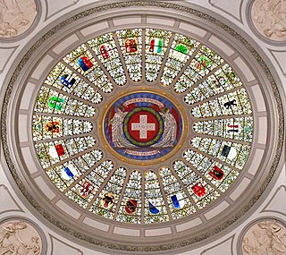
Each of the 26 modern cantons of Switzerland has an official flag and a coat of arms. The history of development of these designs spans the 13th to the 20th centuries.

The Old Swiss Confederacy began as a late medieval alliance between the communities of the valleys in the Central Alps, at the time part of the Holy Roman Empire, to facilitate the management of common interests such as free trade and to ensure the peace along the important trade routes through the mountains. The Hohenstaufen emperors had granted these valleys reichsfrei status in the early 13th century. As reichsfrei regions, the cantons of Uri, Schwyz, and Unterwalden were under the direct authority of the emperor without any intermediate liege lords and thus were largely autonomous.
During the French Revolutionary Wars, the revolutionary armies marched eastward, enveloping Switzerland in their battles against Austria. In 1798, Switzerland was completely overrun by the French and was renamed the Helvetic Republic. The Helvetic Republic encountered severe economic and political problems. In 1798 the country became a battlefield of the Revolutionary Wars, culminating in the Battles of Zürich in 1799.

Erlinsbach is a municipality in the district of Aarau of the canton of Aargau in Switzerland.

The Fricktal is a region on Northwestern Switzerland, comprising the Laufenburg and Rheinfelden districts of the Swiss canton of Aargau. The region was known as Frickgau in the medieval period, ultimately from a Late Latin [regio] ferraricia, in reference to the iron mine located here in the Roman era, also transferred to the village of Frick as the main settlement.
Safenwil is a municipality in the district of Zofingen in the canton of Aargau in Switzerland.
The Swiss Confederation comprises the 26 cantons of Switzerland.
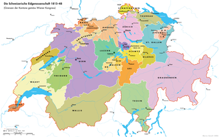
The periods of Restoration and Regeneration in Swiss history lasted from 1814 to 1847. "Restoration" is the period of 1814 to 1830, the restoration of the Ancien Régime (federalism), reverting the changes imposed by Napoleon Bonaparte on the centralist Helvetic Republic from 1798 and the partial reversion to the old system with the Act of Mediation of 1803. "Regeneration" is the period of 1830 to 1848, when in the wake of the July Revolution the "restored" Ancien Régime was countered by the liberal movement. In the Protestant cantons, the rural population enforced liberal cantonal constitutions, partly in armed marches on the cities. This resulted in a conservative backlash in the Catholic cantons in the 1830s, raising the conflict to the point of civil war by 1847.

Kienberg is a municipality in the district of Gösgen in the canton of Solothurn in Switzerland.
The Oberaargau is the region that encompasses the upper watershed of the Aar River in the canton of Bern in Switzerland. On the north, lie the Jura Mountains, and on the south the hills leading to the Emmental.

The Swiss Central Railway was one of the five major private railway companies of Switzerland. The SCB with a track length of 332 kilometres was integrated into the Swiss Federal Railways (SBB) in 1902.
The Kyburg family was a noble family of grafen (counts) in the Duchy of Swabia, a cadet line of the counts of Dillingen, who in the late 12th and early 13th centuries ruled the County of Kyburg, corresponding to much of what is now Northeastern Switzerland.
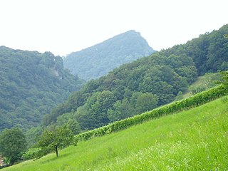
The Wasserflue is a mountain of the Jura, located north of Erlinsbach in the canton of Aargau. It lies on the range east of the Salhöhe Pass.
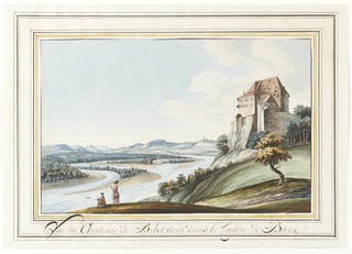
Biberstein Castle is a castle in the municipality of Biberstein in the Swiss canton of Aargau.
This page is based on this
Wikipedia article Text is available under the
CC BY-SA 4.0 license; additional terms may apply.
Images, videos and audio are available under their respective licenses.

 Border stone with the Austrian coat of arms representing Further Austria
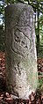 Reverse side with coat of arms of Bern