
The Potomac River is a major river in the Mid-Atlantic region of the United States that flows from the Potomac Highlands in West Virginia to the Chesapeake Bay in Maryland. It is 405 miles (652 km) long, with a drainage area of 14,700 square miles (38,000 km2), and is the fourth-largest river along the East Coast of the United States and the 21st-largest in the United States. More than 5 million people live within its watershed.

The Chesapeake Bay is the largest estuary in the United States. The Bay is located in the Mid-Atlantic region and is primarily separated from the Atlantic Ocean by the Delmarva Peninsula, including parts of the Eastern Shore of Maryland, the Eastern Shore of Virginia, and the state of Delaware. The mouth of the Bay at its southern point is located between Cape Henry and Cape Charles. With its northern portion in Maryland and the southern part in Virginia, the Chesapeake Bay is a very important feature for the ecology and economy of those two states, as well as others surrounding within its watershed. More than 150 major rivers and streams flow into the Bay's 64,299-square-mile (166,534 km2) drainage basin, which covers parts of six states, New York, Pennsylvania, Delaware, Maryland, Virginia, and West Virginia, and all of Washington, D.C.

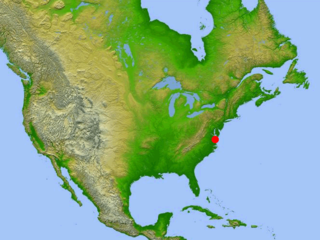
The Delmarva Peninsula, or simply Delmarva, is a large peninsula and proposed state on the East Coast of the United States, occupied by the vast majority of the state of Delaware and parts of the Eastern Shore of Maryland and Eastern Shore of Virginia.

The Chesapeake & Delaware Canal is a 14-mile (22.5 km)-long, 450-foot (137.2 m)-wide and 35-foot (10.7 m)-deep ship canal that connects the Delaware River with the Chesapeake Bay in the states of Delaware and Maryland in the United States.

"Tidewater" is a term for the north Atlantic Plain region of the United States.
The Chesapeake Bay impact crater is a buried impact crater, located beneath the mouth of Chesapeake Bay, United States. It was formed by a bolide that struck the eastern shore of North America about 35.5 ± 0.3 million years ago, in the late Eocene epoch. It is one of the best-preserved "wet-target" impact craters in the world.

The Pocomoke River stretches approximately 66 miles (106 km) from southern Delaware through southeastern Maryland in the United States. At its mouth, the river is essentially an arm of Chesapeake Bay, whereas the upper river flows through a series of relatively inaccessible wetlands called the Great Cypress Swamp, largely populated by Loblolly Pine, Red Maple and Bald Cypress. The river is the easternmost river that flows into Chesapeake Bay. "Pocomoke", though traditionally interpreted as "dark water" by local residents, is now agreed by scholars of the Algonquian languages to be derived from the words for "broken ground."
The Wicomico River is a 24.4-mile-long (39.3 km) tributary of the Chesapeake Bay on the eastern shore of Maryland. It drains an area of low marshlands and farming country in the middle Delmarva Peninsula.

U.S. Route 13 or U.S. Highway 13 (US 13) is a north–south United States Numbered Highway established in 1926 that runs for 518 miles (834 km) from Interstate 95 (I-95) just north of Fayetteville, North Carolina, to US 1 in the northeastern suburbs of Philadelphia, Pennsylvania, near Morrisville. In all, it traverses five states in the Atlantic coastal plain region. It follows the Atlantic coast more closely than does the main north–south U.S. Highway of the region, US 1. Due to this, its number is out of place on the general U.S. Highway numbering grid, as it should be running west of US 11 but does not. Its routing is largely rural, the notable exceptions being the Hampton Roads area in Virginia and the northern end of the highway in Delaware and Pennsylvania. It is also notable for being the main thoroughfare for the Delmarva Peninsula and carrying the Chesapeake Bay Bridge–Tunnel to it in Virginia.

The Chesapeake Bay Bridge–Tunnel is a 17.6-mile (28.3 km) bridge–tunnel that crosses the mouth of the Chesapeake Bay between Delmarva and Hampton Roads in the U.S. state of Virginia. It opened in 1964, replacing ferries that had operated since the 1930s. A major project to dualize its bridges was completed in 1999, and in 2017 a similar project was started to dualize one of its tunnels.

The Eastern Shore of Virginia is the easternmost region of the Commonwealth of Virginia in the United States. It consists of two counties on the Atlantic coast. It is detached from the mainland of Virginia by the Chesapeake Bay. The 70-mile-long (110 km) region is part of the Delmarva Peninsula. Its population was 45,695 as of 2020.

The Eastern Shore of Maryland is a part of the U.S. state of Maryland that lies mostly on the east side of the Chesapeake Bay. Nine counties are normally included in the region. The Eastern Shore is part of the larger Delmarva Peninsula that Maryland shares with Delaware and Virginia.
The Nanticoke River is a tributary of the Chesapeake Bay on the Delmarva Peninsula. It rises in southern Kent County, Delaware, flows through Sussex County, Delaware, and forms the boundary between Dorchester County, Maryland and Wicomico County, Maryland. The tidal river course proceeds southwest into the Tangier Sound, Chesapeake Bay. The river is 64.3 miles (103.5 km) long. A 26-mile ecotourism water trail running along the River was set aside in July 2011 by Delaware state and federal officials, contiguous with a 37-mile water-trail extending through Maryland to the Chesapeake Bay.

The Elk River is a tidal tributary of the Chesapeake Bay on the Eastern Shore of Maryland and on the northern edge of the Delmarva Peninsula. It is about 15 miles (24 km) long. As the most northeastern extension of the Chesapeake Bay estuary, it has served as one entrance to the Chesapeake & Delaware Canal since the 19th century. The canal and river now serve as one boundary of the Elk Neck Peninsula. The river flows through Cecil County, Maryland, with its watershed extending into New Castle County, Delaware and Chester County, Pennsylvania. Elkton, the county seat of Cecil County, is located at its head. Its total watershed area is 143 square miles (370 km2), with 21 square miles (54 km2) of open water, so its watershed is 15% open water. It is south and east of the North East River, and north of the Sassafras River.
The Coon Creek Formation is a geologic formation located in western Tennessee and extreme northeast Mississippi. It is a sedimentary sandy marl deposit, Late Cretaceous (Maastrichtian) in age, about 70 million years old. The formation is known for producing mosasaurs and plesiosaurs, particularly at Coon Creek in McNairy County, Tennessee, which the formation is named for. Additionally, the formation produces many other marine invertebrates such as Turritella and the state fossil of Tennessee, the bivalve Pterotrigonia thoracica, as well as other fossils such as crabs.

The Atlantic Plain is one of eight distinct physiographic divisions of the contiguous United States. Using the USGS physiographic classification system, the Atlantic Plain division comprises two provinces and six sections. The Coastal Plain province is differentiated from the Continental Shelf province simply based on the portion of the land mass above and below sea level.
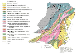
The geology of Delaware consists of two physiographic provinces located in the U.S. state of Delaware. They are the Atlantic Coastal Plain and the Piedmont.
The Atlantic Seaboard Fall Line, or Fall Zone, is a 900-mile (1,400 km) escarpment where the Piedmont and Atlantic coastal plain meet in the eastern United States. Much of the Atlantic Seaboard fall line passes through areas where no evidence of faulting is present.
The Nanjemoy Formation is a geologic formation pertaining to both the Wilcox Group and the Pamunkey Group of the eastern United States, stretching across the states of Virginia, Maryland, and District of Columbia. The formation crops out east of the Appalachians and dates back to the Paleogene period. Specifically to the Ypresian stage of the Eocene epoch, about 55 to 50 Ma or Wasatchian in the NALMA classification, defined by the contemporaneous Wasatch Formation of the Pacific US coast.

The geology of Virginia began to form 1.8 billion years ago and potentially even earlier. The oldest rocks in the state were metamorphosed during the Grenville orogeny, a mountain building event beginning 1.2 billion years ago in the Proterozoic, which obscured older rocks. Throughout the Proterozoic and Paleozoic, Virginia experienced igneous intrusions, carbonate and sandstone deposition, and a series of other mountain building events which defined the terrain of the inland parts of the state. The closing of the Iapetus Ocean, to form the supercontinent Pangaea added additional small landmasses, some of which are now hidden beneath thick Atlantic Coastal Plain sediments. The region subsequently experienced the rifting open of the Atlantic Ocean in the Mesozoic, the development of the Coastal Plain, isolated volcanism and a series of marine transgressions that flooded much of the area. Virginia has extensive coal, deposits of oil and natural gas, as well as deposits of other minerals and metals, including vermiculite, kyanite and uranium.
