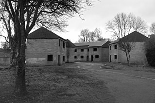
Imber is an uninhabited village and former civil parish within the British Army's training area, now in the parish of Heytesbury, on Salisbury Plain, Wiltshire, England. It lies in an isolated area of the Plain, about 2+1⁄2 miles (4 km) west of the A360 road between Tilshead and West Lavington. A linear village, its main street follows the course of a stream.

The Royal School of Artillery (RSA) is the principal training establishment for artillery warfare in the British Army. Established in 1915, it is based at Larkhill, Wiltshire, on the south edge of the Salisbury Plain Training Area. The school is the primary training facility for Royal Artillery recruits, and is also home to the Gunnery Training Team.
Larkhill is a garrison town in the civil parish of Durrington, Wiltshire, England. It lies about 1+3⁄4 miles (2.8 km) west of the centre of Durrington village and 1+1⁄2 mi (2.4 km) north of the prehistoric monument of Stonehenge. It is about 10 mi (16 km) north of Salisbury.

Allington is a village and civil parish in Wiltshire, England, about 3 miles (5 km) southeast of Amesbury and 7 miles (11 km) northeast of Salisbury. The parish includes the village of Boscombe; both villages are on the River Bourne and the A338 road. Most of the west boundary of the parish is also the county boundary with Hampshire.

Bulford is a village and civil parish in Wiltshire, England, near Salisbury Plain. The village is close to Durrington and about 1.5 miles (2.4 km) north of the town of Amesbury. The Bulford Camp army base is separate from the village but within the parish.

Chitterne is a village and civil parish in the county of Wiltshire, in the south west of England. The village lies in the middle of Salisbury Plain, about 7 miles (11 km) east of the town of Warminster.

Old Sarum Airfield is a grass strip airfield 2 nautical miles north-north-east of Salisbury, in Laverstock parish, Wiltshire, England.

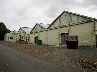
Royal Air Force Keevil or more simply RAF Keevil is a former Royal Air Force station lying between the villages of Keevil and Steeple Ashton, about 4 miles (6.4 km) east of the town of Trowbridge, in Wiltshire, England.
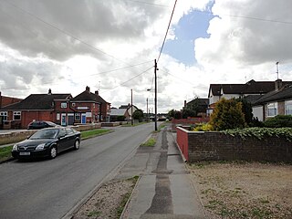
Durrington is a village and civil parish in Wiltshire, England. The village lies about 2 miles (3.2 km) north of the town of Amesbury, 10 miles (16 km) north-northeast of the city of Salisbury, and 2+1⁄2 miles (4 km) northeast of the Stonehenge monument. It is on the eastern part of Salisbury Plain, the largest remaining area of chalk grassland in northwest Europe. The parish includes the hamlet of Hackthorn, on the northern outskirts of Durrington, and the military settlement of Larkhill, 1.5 miles (2.4 km) to the west.

The Bulford Kiwi is a large depiction of a kiwi, carved in the chalk on Beacon Hill above the military town of Bulford on Salisbury Plain in Wiltshire, England. It was created in 1919 by soldiers of the New Zealand Expeditionary Force who were awaiting repatriation following the end of the First World War.

Netheravon is a village and civil parish on the River Avon and A345 road, about 4 miles (6.4 km) north of the town of Amesbury in Wiltshire, South West England. It is within Salisbury Plain.

Bulford Camp is a military camp on Salisbury Plain in Wiltshire, England. Established in 1897, the site continues in use as a large British Army base. The camp is close to the village of Bulford and is about 2+1⁄4 miles (3.6 km) north-east of the town of Amesbury. The camp forms part of the Tidworth, Netheravon and Bulford (TidNBul) Garrison.

Figheldean is a village and civil parish on the River Avon, 3+1⁄2 miles (6 km) north of Amesbury in Wiltshire, England.

Netheravon Airfield is a Ministry of Defence grass strip airfield on Salisbury Plain, in Wiltshire, England. Established in 1913 by the Royal Flying Corps, it became RAF Netheravon from 1918 until 1963, then AAC Netheravon until 2012. Buildings from 1913 and 1914 survive on part of the site. The site forms part of the Tidworth, Netheravon and Bulford (TidNBul) Garrison.
The Amesbury and Military Camp Light Railway was a branch line in Wiltshire, England, constructed under a light railway order dated 24 September 1898. It was opened for military traffic from Amesbury to the east-facing Newton Tony Junction on 1 October 1901. A west-facing junction, Amesbury Junction, where the branch burrowed under the main line, opened on 2 June 1902. The line closed in 1963.

Rollestone is a small village and former civil parish, now in the parish of Shrewton, on Salisbury Plain, in Wiltshire, England. It is near the River Till. Its nearest town is Amesbury, about 5 miles (8.0 km) away to the east.

Waterloo Lines is a British Army barracks on Imber Road in Warminster, Wiltshire, England. It is currently home to a number of Army specialist training schools and a sizeable portion of the Headquarters Field Army.
South West District was a district command of the British Army between 1967 and 1995.
Policing in the English county of Wiltshire (including the borough of Swindon) is the responsibility of several civilian and military authorities.
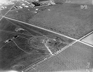
Stonehenge Aerodrome or Stonehenge Airfield was a short-lived military airfield of the Royal Flying Corps on Salisbury Plain in Wiltshire, England, in use from 1917 to 1921. It was built around 300 metres (980 ft) south-west of Stonehenge on the site of existing cottages, and spanned both sides of the New Direct Road turnpike. The base was opened in November 1917, construction having started earlier in that year, as part of the scaling up of military flying capability for World War I. The aerodrome was not complete when the war ended, but construction continued past the end of the war.


