Amesbury and Military Camp Light Railway

Last updated

Contents

Amesbury & 
Military Camp
Light Railway
BSicon exKBSTa.svg
Sling Camp
BSicon exBST.svg
Bulford Camp
BSicon exHST.svg
Bulford
BSicon exHST.svg
Amesbury
BSicon exHST.svg
Newton Tony
BSicon lv-HST.svg
BSicon CONTg@Gq.svg
BSicon eABZqlr.svg
BSicon CONTfq.svg
Grateley

West of England Main Line

The Amesbury and Military Camp Light Railway (also known as the Bulford Camp Railway) was a branch line in Wiltshire, England, constructed under a light railway order dated 24 September 1898. It was opened for military traffic from Amesbury to the east-facing Newton Tony Junction (on the London and South Western Railway main line from Andover to Salisbury, part of the West of England line) on 1 October 1901. A west-facing junction, Amesbury Junction, where the branch burrowed under the main line, opened on 2 June 1902. The line closed in 1963.

Previous proposals

Although the line did not open until the early 1900s, various other proposals had been put forward, but none had succeeded in being built. Before the Bulford Camp branch opened, all nearby railway routes had skirted Salisbury Plain, but none led through it. [1]

Bristol and London & South Western Junction Railway

This was a proposal by the London and South Western Railway which was designed, essentially, to poach traffic from the Great Western Railway. A Bill was deposited in Parliament in November 1882, for a line to branch away from the LSWR between Salisbury and Basingstoke at a point around two miles west of Grateley railway station. It would cross the plain via Amesbury and Shrewton to Westbury and then on to Bristol via either the Somerset and Dorset Joint Railway or the North Somerset Railway. The Great Western Railway was bitterly opposed to this plan and succeeded in defeating it in 1883. [1]

Pewsey and Salisbury Railway

Having defeated the scheme of the LSWR, the Great Western Railway then put forward a scheme of its own. This proposed a route from Pewsey railway station on their main line, leading south over the Plain and then onward to Southampton. However, Southampton was considered to be within LSWR territory, and the encroachment was opposed in much the same way as the B&L&SWJR had been. Although a section between Pewsey and Salisbury was authorised on 16 January 1883, this was never built. [1]

Light railways

No more schemes were proposed until the passing of the Light Railways Act in 1896. The Great Western Railway swiftly saw the advantages of this approach and proposed a route which was very similar to their failed scheme of 1883. This light railway was to run up the Avon valley from Bemerton (near Salisbury) to Amesbury via Stratford, Woodford, Durnford and Wilsford. From Amesbury, the line was to continue to follow the Avon upstream to Pewsey via Durrington, Netheravon, Upavon and Manningford. The line was authorised on 6 August 1898. [1]

In the meantime, the War Office had been purchasing large areas of Salisbury Plain, and had already commenced negotiations with the LSWR for a light railway, very like the 1882 scheme. This would run from Grateley station and over the Plain, via Newton Tony and Amesbury, to a terminus just east of Shrewton, making the line 10 miles and 62 chains long. It was intended to serve both the new military camps and the agricultural community. This line was authorised as the Amesbury & Military Camp Light Railway. Of the two proposals, this scheme won out because the Great Western Railway's proposal involved crossing over four miles of land owned by the War Office, which was supporting the LSWR. [1]

Construction

The LSWR awarded the contract for the railway to Joseph Firbank, who was already involved with other work in the area, principally the Basingstoke and Alton Light Railway. He is also believed to have been the contractor who worked on the Charnwood Forest Railway. Although the line was officially a light railway, it was built to far more substantial standards, with heavy engineering works required. The way was laid with steel bullhead rails weighing 87lbs (heavier than some ordinary railways) and land had been obtained for double tracks, which was unusual for a light railway. In the event, the track was doubled. [1]

Opening

The line opened to goods on 26 April 1902 and passenger traffic commenced on 2 June 1902. [1] From the outset, the line was worked by the L&SWR. When passenger services commenced, the first train to arrive at Amesbury brought the newspapers announcing the end of the South African War.

Operation

Traffic consisted of six passenger trains and one goods train per day. The line was extended to Bulford on 1 June 1906 and, at some stage, to Bulford Camp.

World War I extensions

Further extensions were constructed during World War I, consisting of lines from Amesbury to Larkhill Military Camp, [2] and then westward to Rollestone Camp where there was a balloon school. A further extension was added south-east from Rollestone to Fargo, where there was a military hospital; this line then dividing with one branch going south to Druid's Lodge and one to Stonehenge. Aircraft hangars existed at both these locations. These extensions were operated by the R.O.D. (Railway Operating Division) of the Royal Engineers and they remained in use until about 1923.

Closure

The stations closed in 1952 along with Amesbury junction. The branch as a whole (including Newton Tony junction) ceased goods traffic in 1963. Part of its route became the Winterbourne Downs nature reserve, owned by the Royal Society for the Protection of Birds. [3] Although there has been significant development in the region since the closure, it is still possible to trace the original route that the railway took from aerial photographs. In many places, the railway trackbed now forms footpaths and bridlepaths, and elsewhere it is possible to identify the route in agricultural fields. The platform at Sling Camp remains in undergrowth behind a building housing the Sling borehole on Tidworth Road. An old railway signal can be found in Bulford, at the junction between Double Hedges and Newmans Way.

Related Research Articles

<span class="mw-page-title-main">London and South Western Railway</span> British pre-grouping railway company

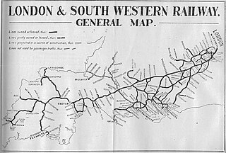
The London and South Western Railway was a railway company in England from 1838 to 1922. Originating as the London and Southampton Railway, its network extended to Dorchester and Weymouth, to Salisbury, Exeter and Plymouth, and to Padstow, Ilfracombe and Bude. It developed a network of routes in Hampshire, Surrey and Berkshire, including Portsmouth and Reading.
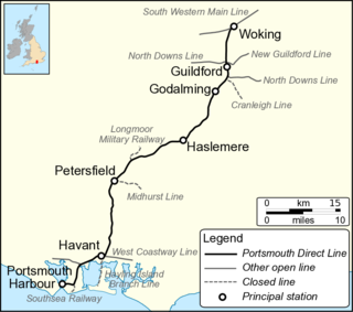
<span class="mw-page-title-main">Plymouth, Devonport and South Western Junction Railway</span> Former English railway company

The Plymouth, Devonport and South Western Junction Railway (PD&SWJR) was an English railway company. It constructed a main line railway between Lydford and Devonport, in Devon, England, enabling the London and South Western Railway (LSWR) to reach Plymouth more conveniently than before.

<span class="mw-page-title-main">Larkhill</span> Army Garrison near Salisbury in Wiltshire, England

Larkhill is a garrison town in the civil parish of Durrington, Wiltshire, England. It lies about 1+34 miles (2.8 km) west of the centre of Durrington village and 1+12 mi (2.4 km) north of the prehistoric monument of Stonehenge. It is about 10 mi (16 km) north of Salisbury.

<span class="mw-page-title-main">Bulford</span> Village and civil parish in Wiltshire, England, close to Salisbury Plain

Bulford is a village and civil parish in Wiltshire, England, close to Salisbury Plain. The village is close to Durrington and about 1.5 miles (2.4 km) north of the town of Amesbury. The Bulford Camp army base is separate from the village but within the parish.

<span class="mw-page-title-main">Durrington, Wiltshire</span> Village and civil parish in Wiltshire, England

Durrington is a village and civil parish in Wiltshire, England. The village lies about 2 miles (3.2 km) north of the town of Amesbury, 10 miles (16 km) north-northeast of the city of Salisbury, and 2+12 miles (4 km) northeast of the Stonehenge monument. It is on the eastern part of Salisbury Plain, the largest remaining area of chalk grassland in northwest Europe. The parish includes the hamlet of Hackthorn, on the northern outskirts of Durrington, and the military settlement of Larkhill, 1.5 miles (2.4 km) to the west.

The Wilts, Somerset and Weymouth Railway (WS&WR) was an early railway company in south-western England. It obtained Parliamentary powers in 1845 to build a railway from near Chippenham in Wiltshire, southward to Salisbury and Weymouth in Dorset. It opened the first part of the network but found it impossible to raise further money and sold its line to the Great Western Railway (GWR) in 1850.

The Sprat and Winkle Line was the common name of the Andover to Redbridge railway line which ran between Andover and Redbridge in Hampshire, England. In the Romsey area it joined, and then left, the Salisbury to Southampton line. It was built by the Andover and Redbridge Railway, which was incorporated in 1858. In 1863 the uncompleted railway was taken over by the London and South Western Railway (LSWR), which opened the line in 1865. The line had been conceived as part of a trunk route from Manchester to Southampton, but when the Midland and South Western Junction Railway opened, the anticipated long-distance traffic was disappointing.

The Salisbury and Dorset Junction Railway was a railway company, that built a line from a junction near Salisbury to another near West Moors on the Ringwood to Wimborne line. It ran through the counties of Wiltshire, Hampshire and Dorset in England. It opened the line in 1866, and was worked by the London and South Western Railway (LSWR).

<span class="mw-page-title-main">Southampton and Dorchester Railway</span>

The Southampton and Dorchester Railway was an English railway company formed to join Southampton in Hampshire with Dorchester in Dorset, with hopes of forming part of a route from London to Exeter. It received Parliamentary authority in 1845 and opened in 1847.

This article describes the history and operation of the railway routes west of Salisbury built by the London and South Western Railway (LSWR) and allied companies, which ultimately became part of the Southern Railway in the United Kingdom. Salisbury forms a natural boundary between the Southern Railway core routes in the counties surrounding London, and the long route connecting with the Devon and Cornwall lines.

<span class="mw-page-title-main">Amesbury railway station</span> Disused railway station in Amesbury, Wiltshire

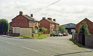
Amesbury railway station was a station in the county of Wiltshire in southern England. It was located on the Bulford Camp branch line, which diverged from what is now known as the West of England Main Line at a triangular junction between Grateley and Idmiston Halt. When it was open, Amesbury was the nearest station to Stonehenge and carried a lot of traffic to the military areas in and around Salisbury Plain, particularly during the Second World War in the preparations for D-Day.

The Salisbury branch line of the Great Western Railway from Westbury to Salisbury in Wiltshire, England, was completed in 1856. Most of the smaller stations were closed in 1955 but the line remains in use as part of the Wessex Main Line.

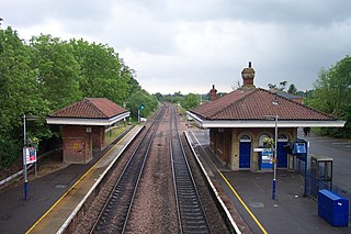
The Salisbury and Yeovil Railway linked Salisbury (Wiltshire), Gillingham (Dorset) and Yeovil (Somerset) in England. Opened in stages in 1859 and 1860, it formed a bridge route between the main London and South Western Railway (LSWR) network and its lines in Devon and Cornwall. Its trains were operated by the LSWR and it was sold to that company in 1878. Apart from a short section in Yeovil it remains open and carries the London Waterloo to Exeter service of South Western Railway.

<span class="mw-page-title-main">Rollestone</span> Human settlement in England

Rollestone is a small village and former civil parish on Salisbury Plain in Wiltshire, England. It is near the River Till. Its nearest town is Amesbury, about 5 miles (8.0 km) away to the east.

<span class="mw-page-title-main">Newton Tony</span> Village in Wiltshire, England

Newton Tony is a rural English village and civil parish in the county of Wiltshire, close to the border with Hampshire. Situated in the Bourne Valley, Newton Tony is about 9 miles (14 km) north-east of its post town, Salisbury. Wilbury House, a Grade I listed 17th-century mansion, stands in parkland in the north of the parish.

<span class="mw-page-title-main">Bulford railway station</span> Served the village of Bulford in Wiltshire, England, between 1906 and 1963

Bulford railway station served the village of Bulford in Wiltshire, England, between 1906 and 1963.

The Aldershot and Alton lines of the LSWR were railways developed from 1849 onwards in the region in Surrey and Hampshire, England, between the Southampton main line and Guildford. First was a line from Guildford to Farnham, soon extended to Alton in 1852. The Reading, Guildford and Reigate Railway, an affiliate of the South Eastern Railway (SER), used part of that line by running powers. When the Aldershot Garrison and associated camps opened, suddenly Aldershot had a large population, both civilian and military, and the LSWR built a line from Pirbright Junction, on the Southampton main line. As well as serving Aldershot, this line gave a more direct route from London. It opened in 1870.

References

  1. 1 2 3 4 5 6 7 Harding, Peter. The Bulford Branch Line. Binfield Printers, 1991, pp.4-5
  2. Baggs, A.P.; Freeman, Jane; Stevenson, Janet H (1987). Crowley, D.A. (ed.). "Victoria County History – Wiltshire – Vol 15 pp93-105 – Parishes: Durrington". British History Online. University of London. Retrieved 30 July 2016.
  3. "Winterbourne Downs". RSPB. Retrieved 16 April 2016.