Related Research Articles

White Rock is an unincorporated community and census-designated place (CDP) in Los Alamos County, New Mexico. It is one of two major population centers in the county; the other is Los Alamos. The population was 5,725 at the 2010 census. It is largely a bedroom community for employees of Los Alamos National Laboratory and their families. Access to White Rock from the town of Los Alamos and other cities and towns in New Mexico is via New Mexico State Road 4, which forms the northwestern boundary of the community. Administratively, White Rock is a neighborhood of Los Alamos; locals refer to Los Alamos as "the Townsite," or "the Hill".

The Sierra Nacimiento, or Nacimiento Mountains, are a mountain range in the northwestern part of the U.S. state of New Mexico. They are just west of the more prominent Jemez Mountains near the town of Cuba, and are separated from them by the Río Guadalupe and the Río de Las Vacas. This article will consider them as a unit together with the San Pedro Mountains, which are a smaller range contiguous with the Sierra Nacimiento on the north, and which are also part of the Nacimiento Uplift and lie at the edge of the greater San Juan Basin, which sits atop the Colorado Plateau. The combined range runs almost due north-south with a length of about 40 mi (65 km). The highest point in the combined range is the high point of the San Pedro Peaks, known unofficially as San Pedro Peak, 10,605 ft.

The Cumbres and Toltec Scenic Railroad, often abbreviated as the C&TSRR, is a 3 ft narrow-gauge heritage railroad that operates on 64 miles (103 km) of track between Antonito, Colorado, and Chama, New Mexico, in the United States. The railroad is named for two geographical features along the route: the 10,015-foot (3,053 m)-high Cumbres Pass and the Toltec Gorge. Originally part of the Denver and Rio Grande Western Railroad's narrow-gauge network, the line has been jointly owned by the states of Colorado and New Mexico since 1970. Today, the C&TSRR is one of only two remaining parts of the former D&RGW narrow-gauge network, the other being the Durango and Silverton Narrow Gauge Railroad (D&SNG), which runs between the communities of Durango and Silverton, Colorado. The railroad has a total of ten narrow-gauge steam locomotives and two narrow-gauge diesel locomotives on its current roster. The railroad also operates two smaller former D&RGW steam locomotives, Nos. 315 and 168, for special events.

The Rio Chama, a major tributary river of the Rio Grande, is located in the U.S. states of Colorado and New Mexico. The river is about 130 miles (210 km) long altogether. From its source to El Vado Dam its length is about 50 miles (80 km), from El Vado Dam to Abiquiu Dam is about 51 miles (82 km), and from Abiquiu Dam to its confluence with the Rio Grande is about 34 miles (55 km).

The Rio Puerco is a tributary of the Rio Grande in the U.S. state of New Mexico. From its source on the west side of the Nacimiento Mountains, it flows about 230 miles (370 km), generally south to join the Rio Grande about 20 miles (32 km) south of Belen and about 50 miles (80 km) south of Albuquerque. Its drainage basin is about 7,350 square miles (19,000 km2) large, of which probably about 1,130 square miles (2,900 km2) are noncontributing.

The New Mexico meridian, is longitude 106° 53′ 40″ west from Greenwich. It extends throughout New Mexico and into Colorado, and together with the baseline, at latitude 34° 15′ 25″ north, governs township and range surveys in New Mexico, except those in the northwest corner of the state which refer to the Navajo meridian and baseline. The New Mexico meridian and Baseline also provide the basis for township and range surveys in the upper valley of the Rio Grande del Norte in Colorado.

The Rio Puerco Bridge is a Parker through truss bridge located on historic U.S. Route 66 (US 66) in western Bernalillo County, New Mexico, United States, that is listed on the National Register of Historic Places (NRHP).

The Puerco River or Rio Puerco is a tributary of the Little Colorado River in northwestern New Mexico and northeastern Arizona. It flows through arid terrain, including the Painted Desert.

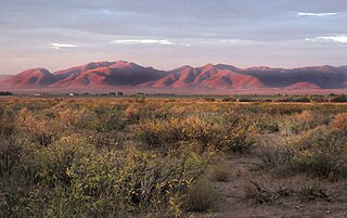
Cabezon Peak is a large volcanic plug that is a prominent feature in northwestern New Mexico. It rises to 7,785 feet in elevation, and nearly 2,000 feet above the floor of the Rio Puerco Valley. Cabezon Peak is two miles south of the old ghost town of Cabezon and the Rio Puerco. This volcanic neck is formed of basalt and is part of the Mount Taylor volcanic field. A volcanic neck or plug is formed when magma from an existing volcano solidifies in the pipe or neck and the surrounding sediment is eroded away. Marine Cretaceous rocks of the Mancos Shale and Point Lookout Sandstone are exposed around the base of Cabezon Peak.
Sublette is a railroad town in northern Rio Arriba County, New Mexico, United States, built as a section station in 1880. It is located north-east of Chama, just south of the Colorado state line and at milepost 306.1 of the former Denver and Rio Grande Western Railroad. When the Denver and Rio Grande abandoned its narrow gauge lines in the late 1960s, two parts of the system were preserved independently: the Cumbres & Toltec Scenic Railroad from Antonito to Chama, including Sublette itself, and the Durango and Silverton Narrow Gauge Railroad. Sublette sits at an elevation of 9,281 feet in the southeastern San Juan Mountains.
El Rito,, is an unincorporated community in Rio Arriba County, New Mexico, United States. Its elevation is 6,875 feet (2,096 m).
Black Creek of Arizona is a 55-mi (89 km) long north tributary of the Puerco River, in northeast Arizona and northwest New Mexico.
The San Pedro Parks Wilderness is located in southern Rio Arriba County in northern New Mexico and part of the Santa Fe National Forest. It is 41,132 acres (16,646 ha) in size. Elevations range from 8,300 feet (2,500 m) in the southwestern corner to 10,592 feet (3,228 m) at San Pedro Peaks near the center of the Wilderness. The Wilderness's average elevation is over 10,000 ft. Conifer forests, interspaced with grassy meadows, called "parks," characterize the wilderness. San Pedro Parks Wilderness is primarily visited for hiking, camping, hunting, and fishing. The Continental Divide Trail passes through the Wilderness.
The Salitral Formation is a Triassic geologic formation of the northwestern Jemez Mountains in New Mexico. It preserves fossils characteristic of the late Triassic.

Laguña Creek also formerly also known as Tyende Creek, is a stream in the Navajo and Apache Counties of Arizona. Laguña Creek has its source at 36°41′15″N110°30′36″W, at the confluence of Long Canyon and Dowozhiebito Canyon at an elevation of 6325 feet / 1928 meters at the head of Tsegi Canyon. Its mouth is in the Chinle Valley at its confluence with Chinle Wash which together forms Chinle Creek, at an elevation of 4774 feet / 1455 meters. Chinle Creek is a tributary of San Juan River which is in turn a tributary of the Colorado River.
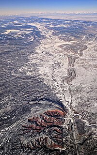
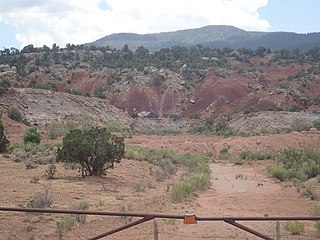
Arroyo Del Agua, is a populated place in Rio Arriba County, New Mexico, United States. It lies at an elevation of 6,834 feet / 2,083 meters along the north bank of the Rio Puerco, above its confluence with its tributary Salitral Creek.
Whitewater Draw, originally Rio de Agua Prieta, [Spanish: river of dark water], is a tributary stream of the Rio de Agua Prieta in Cochise County, Arizona. It was called Blackwater Creek by Philip St. George Cooke when his command, the Mormon Battalion, camped at a spring on its course on December 5, 1846.
Capulin Peak is a summit in Rio Arriba County, New Mexico. It reaches an elevation of 9199 feet / 2804 meters. Its former name in the Tewa language of the nearby Puebloan peoples was Abepin. Its Spanish name was Cerro Capulin, Capulin meaning Choke Cherry. The Armijo Route of the Old Spanish Trail ran westward at the foot of the peak at its south. This route is now closely followed or paralleled by New Mexico, New Mexico State Road 96.
Arroyo Aguaje de la Petaca is a stream or arroyo in Taos County, and Rio Arriba County, New Mexico. Its mouth is at an elevation of 6,050 feet / 1,844 meters, at its confluence with the Rio Grande in Cañon del Rio Grande in Taos County. Its source is at an elevation of 9,135 feet / 3,017 meters, at 36°46′17″N106°07′26″W at Cisneros Park in the Carson National Forest in Rio Arriba County, New Mexico.
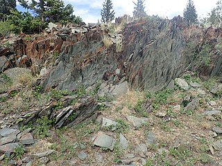
The Moppin Complex is a Precambrian geologic complex found in the Tusas Mountains of northern New Mexico. It has not been directly dated, but is thought to be Statherian based on a minimum age of 1.755 Gya from radiometric dating of magmatic intrusions.
References
- ↑ U.S. Geological Survey Geographic Names Information System: Salitral Creek
- ↑ saltral, definition from Diccionario Enciclopédico Vox 1. © 2009 Larousse Editorial, S.L., from The Free Dictionary, es.thefreedictionary.com accessed February 8, 2016.
Coordinates: 36°09′48″N106°39′28″W / 36.16333°N 106.65778°W